 |
|
Chippewa County International Airport |
| Chippewa County International Airport |
 |
| IATA: CIU – ICAO: KCIU – FAA LID: CIU |
| Summary |
| Airport type |
Public |
| Owner |
Chippewa County EDC |
| Serves |
Sault Ste. Marie, Michigan |
| Elevation AMSL |
800 ft / 244 m |
| Coordinates |
46°15′03″N 084°28′21″W / 46.25083°N 84.4725°W / 46.25083; -84.4725 |
| Website |
www.airciu.com |
| Runways |
| Direction |
Length |
Surface |
| ft |
m |
| 16/34 |
7,200 |
2,195 |
Concrete |
| 9/27 |
4,999 |
1,524 |
Asphalt |
| Statistics (2007) |
| Aircraft operations |
2,403 |
| Based aircraft |
20 |
| Source: Federal Aviation Administration |
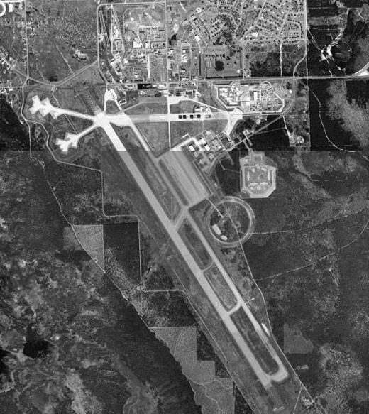
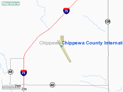
Chippewa County International Airport (IATA: CIU, ICAO: KCIU, FAA LID: CIU) is a public use airport in Chippewa County, Michigan, United States. It is located 15 nautical miles (28 km) south of the central business district of Sault Ste. Marie, Michigan. The airport is owned by the Chippewa County Economic Development Corporation. It was formerly the Kincheloe Air Force Base. Facilities and aircraft
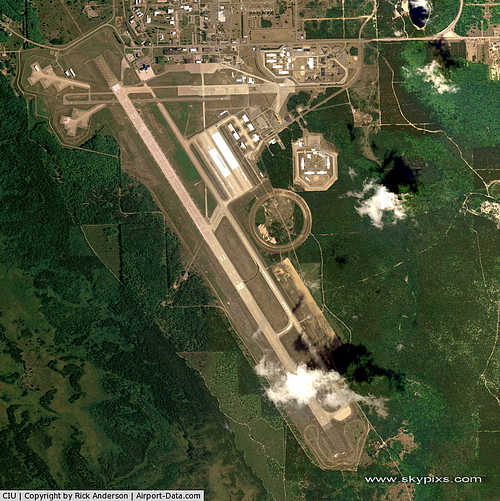
Chippewa County International Airport covers an area of 1,850 acres (749 ha) at an elevation of 800 feet (244 m) above mean sea level. It has two runways: 16/34 is 7,200 by 200 feet (2,195 x 61 m) with a concrete surface; 9/27 is 4,999 by 75 feet (1,524 x 23 m) with an asphalt surface.
The airport opened a new passenger terminal in September 2002. The airport is used mostly for general aviation but is served by one commercial airline. UNICOM is utilized as a common traffic advisory frequency (CTAF) on 123.00mhz, since the original USAF air traffic control tower is unmanned and non-operational. Runway 16/34 has a displaced threshold and was originally 12,000 feet (3,700 m) in length in order to accommodate B-52 and KC-135 aircraft when the airport was an operational Strategic Air Command base. However, 4,800 feet (1,500 m) of the runway has not been maintained and is no longer suitable for takeoffs or landings.
For the 12-month period ending December 31, 2007, the airport had 2,403 aircraft operations, an average of 200 per month: 61% scheduled commercial, 29% general aviation, 8% air taxi and 2% military. At that time there were 20 aircraft based at this airport: 70% single-engine and 30% multi-engine.
Airlines and destinations
| Airlines |
Destinations |
| Delta Connection operated by Mesaba Airlines |
Detroit |
The above content comes from Wikipedia and is published under free licenses – click here to read more.
|
 |
(Click on the photo to enlarge) |
Location & QuickFacts
| FAA Information Effective: | 2008-09-25 |
| Airport Identifier: | CIU |
| Airport Status: | Operational |
| Longitude/Latitude: | 084-28-20.6000W/46-15-02.7000N
-84.472389/46.250750 (Estimated) |
| Elevation: | 800 ft / 243.84 m (Surveyed) |
| Land: | 1850 acres |
| From nearest city: | 15 nautical miles S of Sault Ste Marie, MI |
| Location: | Chippewa County, MI |
| Magnetic Variation: | 06W (1985) |
Owner & Manager
| Ownership: | Publicly owned |
| Owner: | Chippewa County Edc
EDC - ECONOMIC DEVELOPMENT CORP. |
| Address: | 5019 W Airport Dr
Kincheloe, MI 49788 |
| Phone number: | 906-495-5631 |
| Manager: | Kathy L Noel |
| Address: | 5019 W Airport Dr
Kincheloe, MI 49788 |
| Phone number: | 906-495-5631 |
Airport Operations and Facilities
| Airport Use: | Open to public |
| Wind indicator: | Yes |
| Segmented Circle: | Yes |
| Control Tower: | No |
| Lighting Schedule: | DUSK-DAWN
ACTVT HIRL RY 16/34 MIRL RY 09/27; PAPI RYS 16, 09 & 27; REIL RYS 09, 27 & MALSR RY 16, & PAPI & REIL RY 34 APR-NOV - CTAF. RY 34 PAPI & REIL OPERATE CONTINUOSLY DEC - MAR. |
| Beacon Color: | Clear-Green (lighted land airport) |
| Landing fee charge: | No |
| Sectional chart: | Lake Huron |
| Region: | AGL - Great Lakes |
| Traffic Pattern Alt: | 800 ft |
| Boundary ARTCC: | ZMP - Minneapolis |
| Responsible ARTCC: | ZYZ - Toronto |
| Tie-in FSS: | GRB - Green Bay |
| FSS on Airport: | No |
| FSS Toll Free: | 1-800-WX-BRIEF |
| NOTAMs Facility: | CIU (NOTAM-d service avaliable) |
| Certification type/date: | I A S 04/1977
24 HR PPR FOR UNSKED ACR OPNS WITH MORE THAN 9 PSGR SEATS; CALL AMGR 906-495-5631. |
| Federal Agreements: | NGPY |
Airport Communications
| CTAF: | 123.000 |
| Unicom: | 123.000 |
Airport Services
| Fuel available: | 100LLA |
| Bottled Oxygen: | NONE |
| Bulk Oxygen: | NONE |
Runway Information
Runway 09/27
| Dimension: | 4999 x 75 ft / 1523.7 x 22.9 m |
| Surface: | ASPH, Good Condition |
| Surface Treatment: | Saw-cut or plastic Grooved |
| Weight Limit: | Single wheel: 30000 lbs.
Dual wheel: 30000 lbs. |
| Edge Lights: | Medium |
| |
Runway 09 |
Runway 27 |
| Longitude: | 084-29-03.4639W | 084-27-52.3200W |
| Latitude: | 46-15-17.9845N | 46-15-18.0163N |
| Elevation: | 792.00 ft | 789.00 ft |
| Alignment: | 90 | 127 |
| Traffic Pattern: | Left | Left |
| Markings: | Non-precision instrument, Fair Condition | Non-precision instrument, |
| Crossing Height: | 40.00 ft | 40.00 ft |
| VASI: | 4-light PAPI on left side | 4-light PAPI on left side |
| Visual Glide Angle: | 3.00° | 3.00° |
| Runway End Identifier: | Yes | Yes |
| Obstruction: | 57 ft trees, 1900.0 ft from runway, 50 ft left of centerline, 29:1 slope to clear | 51 ft trees, 1800.0 ft from runway, 200 ft left of centerline, 31:1 slope to clear |
|
Runway 16/34
| Dimension: | 7200 x 200 ft / 2194.6 x 61.0 m |
| Surface: | CONC, Fair Condition |
| Surface Treatment: | Saw-cut or plastic Grooved |
| Weight Limit: | Single wheel: 155000 lbs.
Dual wheel: 330000 lbs.
Dual tandem wheel: 600000 lbs. |
| Edge Lights: | High |
| |
Runway 16 |
Runway 34 |
| Longitude: | 084-28-41.1458W | 084-27-49.9084W |
| Latitude: | 46-15-22.8702N | 46-14-21.3176N |
| Elevation: | 799.00 ft | 794.00 ft |
| Alignment: | 127 | 127 |
| ILS Type: | ILS
| |
| Traffic Pattern: | Right | Left |
| Markings: | Precision instrument, Fair Condition | Precision instrument, Fair Condition |
| Crossing Height: | 58.00 ft | 40.00 ft |
| VASI: | 4-light PAPI on left side | 4-light PAPI on left side |
| Visual Glide Angle: | 3.00° | 3.00° |
| Approach lights: | MALSR | |
| Runway End Identifier: | No | Yes |
| Centerline Lights: | No | No |
| Touchdown Lights: | No | No |
|
Radio Navigation Aids
| ID |
Type |
Name |
Ch |
Freq |
Var |
Dist |
| CI | NDB | Koloe | | 400.00 | 06W | 5.7 nm |
| A | NDB | Gros Cap | | 286.00 | 06W | 16.8 nm |
| DRM | NDB | Drummond Island | | 218.00 | 07W | 33.8 nm |
| SSM | VOR/DME | Sault Ste Marie | 059X | 112.20 | 04W | 11.7 nm |
| ERY | VOR/DME | Newberry | 019X | 108.20 | 06W | 41.4 nm |
| PLN | VORTAC | Pellston | 055X | 111.80 | 06W | 38.1 nm |
Remarks
- BIRDS ON & INVOF ARPT.
- EXPC SNOW RMVL ACTIVITY DLY DEC-MAR
- ALL TWYS CLSD EXCEPT TWYS 'A', 'C' & 'D' FM DEC TO APR. CHECK NOTAMS FOR SPECIFIC SCHEDULE OR CTC AMGR 906-495-5631.
- VEHICLE TESTING IN PROGRESS DURING WINTER MONTHS ON SECTIONS FO CLSD/ABNDD PARALLEL TWY, SE OF APCH END RY 34. AREA MAY BE PLOWED TO BARE SFC BUT IS NOT AVBL FOR ACFT ARRS OR DEPS.
- AIRFIELD SFC COND UNMONITORED 1600-0800.
Images and information placed above are from
http://www.airport-data.com/airport/CIU/
We thank them for the data!
| General Info
|
| Country |
United States
|
| State |
MICHIGAN
|
| FAA ID |
CIU
|
| Latitude |
46-15-02.707N
|
| Longitude |
084-28-20.587W
|
| Elevation |
800 feet
|
| Near City |
SAULT STE MARIE
|
We don't guarantee the information is fresh and accurate. The data may
be wrong or outdated.
For more up-to-date information please refer to other sources.
|
|


