 |
|
| Cheboygan County Airport |
| IATA: none – ICAO: KSLH – FAA LID: SLH |
| Summary |
| Airport type |
Public |
| Owner |
Cheboygan Airport Authority |
| Serves |
Cheboygan, Michigan |
| Elevation AMSL |
640 ft / 195 m |
| Coordinates |
45°39′13″N 084°31′09″W / 45.65361°N 84.51917°W / 45.65361; -84.51917 |
| Website |
CheboyganAirport.com |
| Runways |
| Direction |
Length |
Surface |
| ft |
m |
| 10/28 |
4,005 |
1,221 |
Asphalt |
| 16/34 |
1,600 |
488 |
Turf |
| Statistics (2007) |
| Aircraft operations |
6,854 |
| Based aircraft |
18 |
| Source: Federal Aviation Administration |
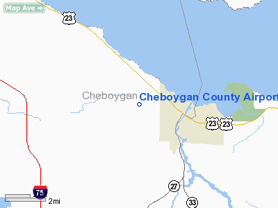
Cheboygan County Airport (ICAO: KSLH, FAA LID: SLH) is a public use airport located two nautical miles (3.7 km) west of the central business district of Cheboygan, a city in Cheboygan County, Michigan, United States. It is owned by the Cheboygan Airport Authority. According to the FAA's National Plan of Integrated Airport Systems for 2009–2013, it is classified as a general aviation airport. The airport is accessible from Levering Road and is close to US-23.
Although many U.S. airports use the same three-letter location identifier for the FAA and IATA, this airport is assigned SLH by the FAA and no designation from the IATA (which assigned SLH to Sola Airport on Vanua Lava, one of the Banks Islands, in Torba Province, Vanuatu).
Facilities and aircraft
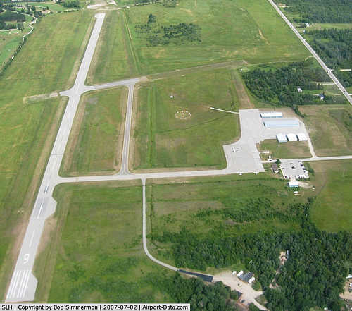
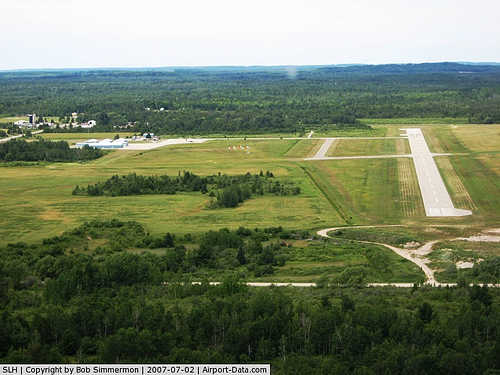
Cheboygan County Airport covers an area of 350 acres (142 ha) at an elevation of 639 feet (195 m) above mean sea level. It has two runways: 10/28 is 4,005 by 75 feet (1,221 x 23 m) with an asphalt pavement and 16/34 is 1,600 by 75 feet (488 x 23 m) with a turf surface.
For the 12-month period ending December 31, 2007, the airport had 6,854 general aviation aircraft operations, an average of 18 per day. At that time there were 18 aircraft based at this airport: 88.9% single-engine, 5.6% multi-engine and 5.6% ultralight.
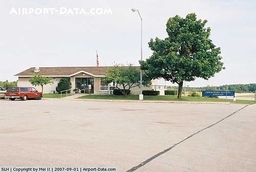
The airport is staffed between 8:30 AM and 4:30 PM.
The above content comes from Wikipedia and is published under free licenses – click here to read more.
|
 |
(Click on the photo to enlarge) |
|
 |
(Click on the photo to enlarge) |
|
 |
(Click on the photo to enlarge) |
|
 |
(Click on the photo to enlarge) |
Location & QuickFacts
| FAA Information Effective: | 2008-09-25 |
| Airport Identifier: | SLH |
| Airport Status: | Operational |
| Longitude/Latitude: | 084-31-09.3830W/45-39-13.3570N
-84.519273/45.653710 (Estimated) |
| Elevation: | 639 ft / 194.77 m (Surveyed) |
| Land: | 350 acres |
| From nearest city: | 2 nautical miles W of Cheboygan, MI |
| Location: | Cheboygan County, MI |
| Magnetic Variation: | 07W (2005) |
Owner & Manager
| Ownership: | Publicly owned |
| Owner: | Cheboygan Airport Authority |
| Address: | 1520 Levering Rd.
Cheboygan, MI 49721 |
| Phone number: | 231-627-5571 |
| Manager: | Del Reynolds |
| Address: | 1520 Levering Rd.
Cheboygan, MI 49721 |
| Phone number: | 231-627-5571 |
Airport Operations and Facilities
| Airport Use: | Open to public |
| Wind indicator: | Yes |
| Segmented Circle: | Yes |
| Control Tower: | No |
| Lighting Schedule: | DUSK-DAWN
ACTVT MIRL RY 09/27; PAPI & REIL RYS 09 & 27 - 122.5. |
| Beacon Color: | Clear-Green (lighted land airport) |
| Landing fee charge: | No |
| Sectional chart: | Lake Huron |
| Region: | AGL - Great Lakes |
| Boundary ARTCC: | ZMP - Minneapolis |
| Tie-in FSS: | LAN - Lansing |
| FSS on Airport: | No |
| FSS Toll Free: | 1-800-WX-BRIEF |
| NOTAMs Facility: | SLH (NOTAM-d service avaliable) |
| Federal Agreements: | NGY |
Airport Communications
| CTAF: | 122.800 |
| Unicom: | 122.800 |
Airport Services
| Fuel available: | 100LLA
FOR JET 1 AFTR HRS CALL 231-627-5864, 231-0420-0334. |
| Airframe Repair: | MAJOR |
| Power Plant Repair: | MAJOR |
Runway Information
Runway 09/27
| Dimension: | 4000 x 75 ft / 1219.2 x 22.9 m |
| Surface: | ASPH, Good Condition
SOFT WHEN WET. |
| Weight Limit: | Single wheel: 23000 lbs.
Dual wheel: 34000 lbs.
Dual tandem wheel: 60000 lbs. |
| Edge Lights: | Medium |
| |
Runway 09 |
Runway 27 |
| Longitude: | 084-31-38.0700W | 084-30-41.7500W |
| Latitude: | 45-39-15.0800N | 45-39-15.1400N |
| Elevation: | 639.00 ft | 627.00 ft |
| Alignment: | 90 | 127 |
| Traffic Pattern: | Left | Left |
| Markings: | Non-precision instrument, Poor Condition
RY 09/27 MARKINGS FADED. | Non-precision instrument, Poor Condition |
| Crossing Height: | 25.00 ft | 25.00 ft |
| VASI: | 2-light PAPI on left side | 2-light PAPI on left side |
| Visual Glide Angle: | 4.00° | 4.00° |
| Runway End Identifier: | Yes | Yes |
| Centerline Lights: | No | No |
| Touchdown Lights: | No | No |
| Obstruction: | 15 ft road, 398.0 ft from runway, 225 ft right of centerline, 13:1 slope to clear
APCH RATIO 26:1 AT RWY END. | 54 ft trees, 1280.0 ft from runway, 20:1 slope to clear
RWY 27 APCH RATIO AT RWY END BASED ON AC 150/5300-13 APX 2, CH 5. |
|
Runway 16/34
| Dimension: | 1500 x 75 ft / 457.2 x 22.9 m |
| Surface: | TURF, Fair Condition
SOFT WHEN WET. |
| |
Runway 16 |
Runway 34 |
| Longitude: | 084-31-11.1360W | 084-31-04.8600W |
| Latitude: | 45-39-16.5430N | 45-39-01.3720N |
| Traffic Pattern: | Left | Left |
| Displaced threshold: | 0.00 ft | 500.00 ft |
| Obstruction: | 17 ft trees, 340.0 ft from runway, 110 ft left of centerline, 20:1 slope to clear | 67 ft trees, 804.0 ft from runway, 125 ft left of centerline, 12:1 slope to clear
APCH RATIO 20:1 AT DSPLCD THLD. |
|
Radio Navigation Aids
| ID |
Type |
Name |
Ch |
Freq |
Var |
Dist |
| PZQ | NDB | Rogers City | | 215.00 | 07W | 33.0 nm |
| BFA | NDB | Boyne Falls | | 263.00 | 06W | 33.8 nm |
| CVX | NDB | Charlevoix | | 392.00 | 05W | 38.1 nm |
| DRM | NDB | Drummond Island | | 218.00 | 07W | 38.9 nm |
| CI | NDB | Koloe | | 400.00 | 06W | 40.8 nm |
| SJX | NDB | St James | | 382.00 | 05W | 43.7 nm |
| GLR | VOR/DME | Gaylord | 029X | 109.20 | 06W | 39.3 nm |
| SSM | VOR/DME | Sault Ste Marie | 059X | 112.20 | 04W | 46.4 nm |
| PLN | VORTAC | Pellston | 055X | 111.80 | 06W | 6.2 nm |
Remarks
- DEER & BIRDS ON & INVOF ARPT.
Images and information placed above are from
http://www.airport-data.com/airport/SLH/
We thank them for the data!
| General Info
|
| Country |
United States
|
| State |
MICHIGAN
|
| FAA ID |
SLH
|
| Latitude |
45-39-13.357N
|
| Longitude |
084-31-09.383W
|
| Elevation |
641 feet
|
| Near City |
CHEBOYGAN
|
We don't guarantee the information is fresh and accurate. The data may
be wrong or outdated.
For more up-to-date information please refer to other sources.
|
|


