 |
|
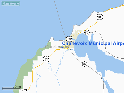
Charlevoix Municipal Airport |
| Charlevoix Municipal Airport |
 |
| IATA: CVX – ICAO: KCVX – FAA LID: CVX |
| Summary |
| Airport type |
Public |
| Owner |
City of Charlevoix |
| Serves |
Charlevoix, Michigan |
| Elevation AMSL |
669 ft / 204 m |
| Coordinates |
45°18′17″N 085°16′31″W / 45.30472°N 85.27528°W / 45.30472; -85.27528 |
| Runways |
| Direction |
Length |
Surface |
| ft |
m |
| 9/27 |
4,550 |
1,387 |
Asphalt |
| 4/22 |
1,280 |
390 |
Turf |
| Statistics (2006) |
| Aircraft operations |
33,000 |
| Source: Federal Aviation Administration |
Charlevoix Municipal Airport (ICAO: KCVX, FAA LID: CVX) is a public airport located one mile (2 km) southwest of the central business district of Charlevoix, a city in Charlevoix County, Michigan, United States. It is owned by the City of Charlevoix and served by one airline.
Although most U.S. airports use the same three-letter location identifier for the FAA and IATA, Charlevoix Municipal Airport is assigned CVX by the FAA Facilities and aircraft
Charlevoix Municipal Airport covers an area of 185 acres (75 ha) which contains two runways: 9/27 has an asphalt pavement measuring 4,550 x 75 ft (1,387 x 23 m) and 4/22 has a turf surface that measures 1,280 x 200 ft (390 x 61 m). For the 12-month period ending December 31, 2006, the airport had 33,000 aircraft operations, an average of 90 per day: 67% general aviation and 33% air taxi.
Airline and destination
- Island Airways (Beaver Island)
The above content comes from Wikipedia and is published under free licenses – click here to read more.
|
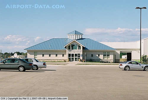 |
(Click on the photo to enlarge) |
Location & QuickFacts
| FAA Information Effective: | 2008-09-25 |
| Airport Identifier: | CVX |
| Airport Status: | Operational |
| Longitude/Latitude: | 085-16-31.2000W/45-18-17.2000N
-85.275333/45.304778 (Estimated) |
| Elevation: | 669 ft / 203.91 m (Surveyed) |
| Land: | 185 acres |
| From nearest city: | 1 nautical miles SW of Charlevoix, MI |
| Location: | Charlevoix County, MI |
| Magnetic Variation: | 05W (1985) |
Owner & Manager
| Ownership: | Publicly owned |
| Owner: | City Of Charlevoix |
| Address: | 210 State Street
Charlevoix, MI 49720 |
| Phone number: | 231-547-3270 |
| Manager: | Paul Welke |
| Address: | 210 State Street
Charlevoix, MI 49720
ARPT PHYSICAL ADDRESS 111 AIRPORT DR., CHARLEVOIX, MI 49720. |
| Phone number: | 231-547-3605 |
Airport Operations and Facilities
| Airport Use: | Open to public |
| Wind indicator: | Yes |
| Segmented Circle: | Yes |
| Control Tower: | No |
| Lighting Schedule: | DUSK-DAWN
ACTVT MIRL RY 09/27; REIL & PAPI RYS 09 & 27 - CTAF. |
| Beacon Color: | Clear-Green (lighted land airport) |
| Landing fee charge: | Yes
LDG FEE WAIVED WITH MINIMUM FUEL PURCHASE. |
| Sectional chart: | Green Bay |
| Region: | AGL - Great Lakes |
| Boundary ARTCC: | ZMP - Minneapolis |
| Tie-in FSS: | LAN - Lansing |
| FSS on Airport: | No |
| FSS Toll Free: | 1-800-WX-BRIEF |
| NOTAMs Facility: | CVX (NOTAM-d service avaliable) |
| Federal Agreements: | N1 |
Airport Communications
| CTAF: | 122.800 |
| Unicom: | 122.800 |
Airport Services
| Fuel available: | 100LLA
FOR FUEL DAWN - DUSK CALL 231-547-2141. AFTER HRS CALL 231-547-2058. |
| Airframe Repair: | MAJOR |
| Power Plant Repair: | MAJOR |
Runway Information
Runway 04/22
| Dimension: | 1280 x 200 ft / 390.1 x 61.0 m |
| Surface: | TURF, Good Condition |
| |
Runway 04 |
Runway 22 |
| Longitude: | 085-16-16.2440W | 085-16-03.4600W |
| Latitude: | 45-18-13.0260N | 45-18-21.8760N |
| Elevation: | 649.00 ft | 0.00 ft |
| Alignment: | 46 | 127 |
| Traffic Pattern: | Left | Left |
| Obstruction: | 43 ft trees, 875.0 ft from runway, 40 ft left of centerline, 20:1 slope to clear | 72 ft tree, 1440.0 ft from runway, 20:1 slope to clear |
|
Runway 09/27
| Dimension: | 4550 x 75 ft / 1386.8 x 22.9 m |
| Surface: | ASPH, Good Condition |
| Weight Limit: | Single wheel: 12500 lbs. |
| Edge Lights: | Medium |
| |
Runway 09 |
Runway 27 |
| Longitude: | 085-17-08.8991W | 085-16-05.5275W |
| Latitude: | 45-18-15.0338N | 45-18-19.2534N |
| Elevation: | 669.00 ft | 643.00 ft |
| Alignment: | 85 | 127 |
| Traffic Pattern: | Left | Left |
| Markings: | Non-precision instrument, Fair Condition
RY 9/27 MARKINGS FADED. | Non-precision instrument, Fair Condition
RWY 9-27 MARKINGS FADED. |
| Crossing Height: | 0.00 ft | 31.00 ft |
| VASI: | 4-light PAPI on right side | 4-light PAPI on right side |
| Visual Glide Angle: | 3.00° | 3.00° |
| Runway End Identifier: | Yes | Yes |
| Obstruction: | 8 ft tree, 360.0 ft from runway, 45 ft right of centerline, 20:1 slope to clear | 50 ft trees, 1800.0 ft from runway, 70 ft right of centerline, 32:1 slope to clear |
|
Radio Navigation Aids
| ID |
Type |
Name |
Ch |
Freq |
Var |
Dist |
| CVX | NDB | Charlevoix | | 392.00 | 05W | 0.3 nm |
| BFA | NDB | Boyne Falls | | 263.00 | 06W | 17.1 nm |
| CXK | NDB | Clam Lake | | 251.00 | 05W | 24.4 nm |
| SJX | NDB | St James | | 382.00 | 05W | 26.2 nm |
| TV | NDB | Gwenn | | 365.00 | 05W | 34.9 nm |
| GYG | NDB | Grayling | | 359.00 | 06W | 38.4 nm |
| CGG | VOR | Grayling | | 109.80 | 06W | 44.1 nm |
| GLR | VOR/DME | Gaylord | 029X | 109.20 | 06W | 29.9 nm |
| PLN | VORTAC | Pellston | 055X | 111.80 | 06W | 32.4 nm |
| TVC | VORTAC | Traverse City | 093X | 114.60 | 02W | 40.0 nm |
Remarks
- RY 09/27 SLOPES UP FROM E TO W.
- DEER & BIRDS ON & INVOF ARPT.
- GCO AVBL ON FREQ 121.725 THRU MINNEAPOLIS ARTCC AND FLT SVCS.
- -100 FT QUARRY/MINE, 300 FT FM RWY 9 THLD.
- GCO FREQ 121.725 OTS INDEFLY.
- RY 09 PREFERRED RY FOR LDG NGTS, JETS & TURBOPROP ACFT.
- RY 27 PREFERRED RY FOR TKOF NGTS, JETS & TURBOPROP ACFT.
- PRIOR TO 1959.
Images and information placed above are from
http://www.airport-data.com/airport/CVX/
We thank them for the data!
| General Info
|
| Country |
United States
|
| State |
MICHIGAN
|
| FAA ID |
CVX
|
| Latitude |
45-18-17.200N
|
| Longitude |
085-16-31.200W
|
| Elevation |
669 feet
|
| Near City |
CHARLEVOIX
|
We don't guarantee the information is fresh and accurate. The data may
be wrong or outdated.
For more up-to-date information please refer to other sources.
|
|


