 |
|
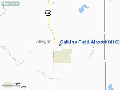
Location & QuickFacts
| FAA Information Effective: | 2008-09-25 |
| Airport Identifier: | 41C |
| Airport Status: | Operational |
| Longitude/Latitude: | 085-38-45.0790W/42-41-30.1140N
-85.645855/42.691698 (Estimated) |
| Elevation: | 740 ft / 225.55 m (Estimated) |
| Land: | 105 acres |
| From nearest city: | 1 nautical miles N of Wayland, MI |
| Location: | Allegan County, MI |
| Magnetic Variation: | 04W (1985) |
Owner & Manager
| Ownership: | Privately owned |
| Owner: | Wayland Area Pilots Assn |
| Address: | 3811 Butterworth
Grand Rapids, MI 49544 |
| Phone number: | 269-672-5582 |
| Manager: | Bruce Kamminga |
| Address: | 8695 Hanna Lake Ave
Wayland, MI 49316 |
| Phone number: | 616-968-8060 |
Airport Operations and Facilities
| Airport Use: | Open to public |
| Wind indicator: | Yes |
| Segmented Circle: | Yes |
| Control Tower: | No |
| Landing fee charge: | No |
| Sectional chart: | Chicago |
| Region: | AGL - Great Lakes |
| Boundary ARTCC: | ZAU - Chicago |
| Tie-in FSS: | LAN - Lansing |
| FSS on Airport: | No |
| FSS Toll Free: | 1-800-WX-BRIEF |
| NOTAMs Facility: | LAN (NOTAM-d service avaliable) |
Airport Communications
Runway Information
Runway 01/19
| Dimension: | 2200 x 75 ft / 670.6 x 22.9 m |
| Surface: | TURF, Fair Condition
RY SURFACE ROUGH & UNEVEN, SOFT WHEN WET. |
| |
Runway 01 |
Runway 19 |
| Longitude: | 085-38-52.0000W | 085-38-46.8800W |
| Latitude: | 42-41-22.5000N | 42-41-43.9000N |
| Elevation: | 740.00 ft | 740.00 ft |
| Traffic Pattern: | Left | Left |
| Displaced threshold: | 800.00 ft | 0.00 ft |
| Obstruction: | 75 ft tree, 510.0 ft from runway, 50 ft right of centerline, 6:1 slope to clear
RY 01 0:1 AT DSPLCD THLD BASED ON A 70 FT TREE, 123 FT L, 0 FT DSTC. 20:1 STRAIGHT OUT. | 50 ft tree, 0.0 ft from runway, 75 ft left of centerline |
|
Runway 09/27
| Dimension: | 1800 x 100 ft / 548.6 x 30.5 m |
| Surface: | TURF, Fair Condition
RY SURFACE ROUGH & UNEVEN, SOFT WHEN WET. |
| |
Runway 09 |
Runway 27 |
| Longitude: | 085-39-02.0000W | 085-38-37.9000W |
| Latitude: | 42-41-30.0000N | 42-41-29.9900N |
| Elevation: | 740.00 ft | 740.00 ft |
| Traffic Pattern: | Left | Left |
| Markings: | None,
09/27 & RY 01/19 & DSPLCD THLDS MKD WITH 3 FT YELLOW CONES. | None, |
| Displaced threshold: | 200.00 ft | 0.00 ft |
| Runway End Identifier: | No | No |
| Centerline Lights: | No | No |
| Touchdown Lights: | No | No |
| Obstruction: | 66 ft trees, 1120.0 ft from runway, 16:1 slope to clear
20:1 AT DSPLCD THLD. | 35 ft tree, 111.0 ft from runway, 100 ft left of centerline, 3:1 slope to clear |
|
Radio Navigation Aids
| ID |
Type |
Name |
Ch |
Freq |
Var |
Dist |
| HLM | NDB | Holland | | 233.00 | 03W | 23.4 nm |
| BT | NDB | Batol | | 272.00 | 04W | 28.5 nm |
| HAI | NDB | Three Rivers | | 407.00 | 02W | 44.1 nm |
| GRR | VOR/DME | Grand Rapids | 106Y | 115.95 | 04W | 8.7 nm |
| PMM | VOR/DME | Pullman | 058X | 112.10 | 00E | 24.4 nm |
| AZO | VOR/DME | Kalamazoo | 027X | 109.00 | 01W | 27.6 nm |
| ELX | VOR/DME | Keeler | 113X | 116.60 | 00E | 39.1 nm |
| BTL | VORTAC | Battle Creek | 031X | 109.40 | 02W | 28.8 nm |
| MKG | VORTAC | Muskegon | 099X | 115.20 | 01W | 33.5 nm |
| LAN | VORTAC | Lansing | 045X | 110.80 | 05W | 41.9 nm |
Remarks
- NO SNOW REMOVAL-VERIFY CONDITIONS CALL 616-698-5041 (MGR. CELL).
Images and information placed above are from
http://www.airport-data.com/airport/41C/
We thank them for the data!
| General Info
|
| Country |
United States
|
| State |
MICHIGAN
|
| FAA ID |
41C
|
| Latitude |
42-41-30.114N
|
| Longitude |
085-38-45.079W
|
| Elevation |
740 feet
|
| Near City |
WAYLAND
|
We don't guarantee the information is fresh and accurate. The data may
be wrong or outdated.
For more up-to-date information please refer to other sources.
|
|


