 |
|
Location & QuickFacts
| FAA Information Effective: | 2008-09-25 |
| Airport Identifier: | 9MI0 |
| Airport Status: | Operational |
| Longitude/Latitude: | 083-39-14.7800W/42-15-52.1370N
-83.654106/42.264482 (Estimated) |
| Elevation: | 837 ft / 255.12 m (Surveyed) |
| Land: | 0 acres |
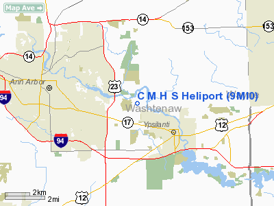
| From nearest city: | 2 nautical miles N of Ypsilanti, MI |
| Location: | Washtenaw County, MI |
| Magnetic Variation: | 05W (1985) |
Owner & Manager
| Ownership: | Privately owned |
| Owner: | Catherine Mcauley Health Sys |
| Address: | 5301 E Huron River Dr Box 992
Ann Arbor, MI 48106 |
| Phone number: | 313-487-5477 |
| Manager: | William Pesel, Ops Mgr |
| Address: | 5305 E Huron Riverdr 311
Ypsilanti, MI 48197 |
| Phone number: | 313-572-5959 |
Airport Operations and Facilities
| Airport Use: | Private |
| Wind indicator: | Yes |
| Segmented Circle: | No |
| Control Tower: | No |
| Lighting Schedule: | PHONE REQ
FOR PERIMETER LGTS CALL 313-572-5959. |
| Sectional chart: | Detroit |
| Region: | AGL - Great Lakes |
| Boundary ARTCC: | ZOB - Cleveland |
| Tie-in FSS: | LAN - Lansing |
| FSS on Airport: | No |
| FSS Toll Free: | 1-800-WX-BRIEF |
Runway Information
Helipad H1
| Dimension: | 60 x 60 ft / 18.3 x 18.3 m |
| Surface: | CONC, |
| |
Runway H1 |
Runway |
| Traffic Pattern: | Left | Left |
| Markings: | Basic, | , |
|
Radio Navigation Aids
| ID |
Type |
Name |
Ch |
Freq |
Var |
Dist |
| TCU | NDB | Tecumseh | | 239.00 | 04W | 17.0 nm |
| RYS | NDB | Grosse Ile | | 419.00 | 06W | 24.4 nm |
| OZW | NDB | Howell | | 243.00 | 05W | 26.7 nm |
| G | NDB | Golf | | 398.00 | 05W | 27.0 nm |
| ADG | NDB | Adrian | | 278.00 | 06W | 30.3 nm |
| VQ | NDB | Cargl | | 230.00 | 05W | 31.6 nm |
| QG | NDB | Windsor | | 353.00 | 06W | 35.1 nm |
| USE | NDB | Fulton | | 375.00 | 05W | 44.8 nm |
| TOL | TACAN | Toledo | 072X | | 05W | 40.8 nm |
| MTC | TACAN | Selfridge | 064X | | 06W | 42.1 nm |
| DXO | VOR/DME | Detroit | 081X | 113.40 | 06W | 13.2 nm |
| JXN | VOR/DME | Jackson | 033X | 109.60 | 05W | 35.8 nm |
| YQG | VOR/DME | Windsor | 085X | 113.80 | 06W | 36.7 nm |
| VWV | VOR/DME | Waterville | 078X | 113.10 | 02W | 48.9 nm |
| SVM | VORTAC | Salem | 090X | 114.30 | 03W | 9.1 nm |
| CRL | VORTAC | Carleton | 104X | 115.70 | 03W | 15.7 nm |
| PSI | VORTAC | Pontiac | 047X | 111.00 | 03W | 26.8 nm |
| FNT | VORTAC | Flint | 116X | 116.90 | 06W | 42.4 nm |
| YIP | VOT | Willow Run | | 112.00 | | 6.1 nm |
| DTW | VOT | Detroit Met Wayne | | 109.80 | | 13.1 nm |
| DET | VOT | Detroit City | | 111.60 | | 29.6 nm |
Remarks
- PRVDD OPNS ARE CONDD IN AREA 030-150 DEG CLKWS, APROPLY MKD, WIND INDCR MAINTD.
Images and information placed above are from
http://www.airport-data.com/airport/9MI0/
We thank them for the data!
| General Info
|
| Country |
United States
|
| State |
MICHIGAN
|
| FAA ID |
9MI0
|
| Latitude |
42-15-52.137N
|
| Longitude |
083-39-14.780W
|
| Elevation |
837 feet
|
| Near City |
YPSILANTI
|
We don't guarantee the information is fresh and accurate. The data may
be wrong or outdated.
For more up-to-date information please refer to other sources.
|
|


