 |
|
| Brooks Field |
 |
| IATA: none – ICAO: KRMY – FAA LID: RMY |
| Summary |
| Airport type |
Public |
| Owner |
City of Marshall |
| Serves |
Marshall, Michigan |
| Elevation AMSL |
941 ft / 287 m |
| Coordinates |
42°15′04″N 084°57′20″W / 42.25111°N 84.95556°W / 42.25111; -84.95556 |
| Runways |
| Direction |
Length |
Surface |
| ft |
m |
| 10/28 |
3,501 |
1,067 |
Asphalt |
| Helipads |
| Number |
Length |
Surface |
| ft |
m |
| H1 |
50 |
15 |
Concrete |
| Statistics (2007) |
| Aircraft operations |
6,000 |
| Based aircraft |
25 |
| Source: Federal Aviation Administration |
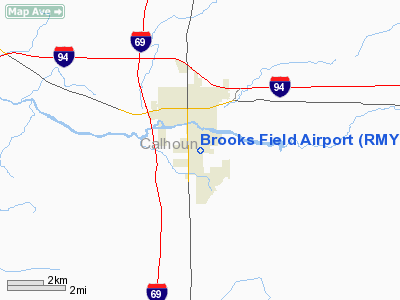
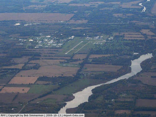
Brooks Field (ICAO: KRMY, FAA LID: RMY) is a city-owned, public-use airport located one nautical mile (1.85 km) south of the central business district of Marshall, a city in Calhoun County, Michigan, United States. Brooks Field was officially dedicated in 1931, although the first plane landed there on November 9, 1929.
Although many U.S. airports use the same three-letter location identifier for the FAA and IATA, this airport is assigned RMY by the FAA and no designation from the IATA. According to the FAA's National Plan of Integrated Airport Systems for 2009–2013, it is categorized as a general aviation airport. Facilities and aircraft
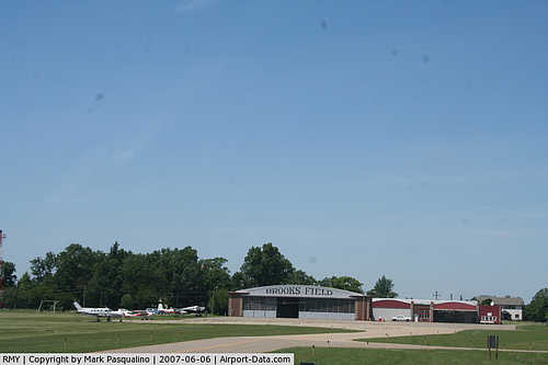
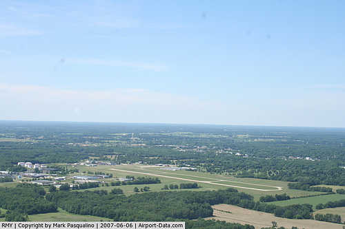
Brooks Field covers an area of 170 acres (69 ha) at an elevation of 941 feet (287 m) above mean sea level. It has one runway designated 10/28 with a asphalt surface measuring 3,501 by 75 feet (1,067 x 23 m). It also has a one helipad designated H1 with a concrete surface measuring 50 by 50 feet (15 x 15 m). The airport is staffed from 8AM until dusk, except for major holidays.
For the 12-month period ending December 31, 2007, the airport had 6,000 general aviation aircraft operations, an average of 16 per day. At that time there were 25 aircraft based at this airport: 76% single-engine, 16% glider and 8% ultralight.
Transit
The closest highway is I-69, which is approximately 2 miles west of the airport. I-94 is also very close to the airport. The airport is accessible by road from Kalamazoo St.
The above content comes from Wikipedia and is published under free licenses – click here to read more.
|
 |
(Click on the photo to enlarge) |
|
 |
(Click on the photo to enlarge) |
|
 |
(Click on the photo to enlarge) |
Location & QuickFacts
| FAA Information Effective: | 2008-09-25 |
| Airport Identifier: | RMY |
| Airport Status: | Operational |
| Longitude/Latitude: | 084-57-19.5995W/42-15-04.2954N
-84.955444/42.251193 (Estimated) |
| Elevation: | 941 ft / 286.82 m (Surveyed) |
| Land: | 170 acres |
| From nearest city: | 1 nautical miles S of Marshall, MI |
| Location: | Calhoun County, MI |
| Magnetic Variation: | 05W (1995) |
Owner & Manager
| Ownership: | Publicly owned |
| Owner: | Christopher Olson |
| Address: | City Of Marshall
Marshall, MI 49068-1578 |
| Phone number: | 269-781-5183
EXT. 1150. |
| Manager: | Mitchell R. Price |
| Address: | City Of Marshall, 323 W. Michigan
Marshall, MI 49068-1578 |
| Phone number: | 269-781-5183
EXT. 1150. |
Airport Operations and Facilities
| Airport Use: | Open to public |
| Wind indicator: | Yes |
| Segmented Circle: | Yes |
| Control Tower: | No |
| Lighting Schedule: | DUSK-DAWN
RY 10/28 MIRL & H-1 PERI PRESET LOW INTST; TO INCR INTST ACTVT - CTAF. |
| Beacon Color: | Clear-Green (lighted land airport) |
| Landing fee charge: | No |
| Sectional chart: | Detroit |
| Region: | AGL - Great Lakes |
| Traffic Pattern Alt: | 1000 ft |
| Boundary ARTCC: | ZOB - Cleveland |
| Responsible ARTCC: | ZAU - Chicago |
| Tie-in FSS: | LAN - Lansing |
| FSS on Airport: | No |
| FSS Toll Free: | 1-800-WX-BRIEF |
| NOTAMs Facility: | RMY (NOTAM-d service avaliable) |
| Federal Agreements: | NGY |
Airport Communications
| CTAF: | 122.800 |
| Unicom: | 122.800 |
Airport Services
Runway Information
Runway 10/28
| Dimension: | 3501 x 75 ft / 1067.1 x 22.9 m |
| Surface: | ASPH, Good Condition |
| Weight Limit: | Single wheel: 20000 lbs. |
| Edge Lights: | Medium |
| |
Runway 10 |
Runway 28 |
| Longitude: | 084-57-42.7199W | 084-56-56.4790W |
| Latitude: | 42-15-06.2892N | 42-15-02.3016N |
| Elevation: | 939.00 ft | 937.00 ft |
| Alignment: | 97 | 127 |
| Traffic Pattern: | Left | Left |
| Markings: | Non-precision instrument, Good Condition | Non-precision instrument, Good Condition |
| Crossing Height: | 25.00 ft | 36.00 ft |
| VASI: | 4-light PAPI on left side | 4-light PAPI on right side |
| Visual Glide Angle: | 4.00° | 4.00° |
| Runway End Identifier: | No | |
| Centerline Lights: | No | No |
| Touchdown Lights: | No | No |
| Obstruction: | 58 ft tree, 1360.0 ft from runway, 250 ft left of centerline, 20:1 slope to clear | 80 ft trees, 1320.0 ft from runway, 14:1 slope to clear |
|
Helipad H1
| Dimension: | 50 x 50 ft / 15.2 x 15.2 m |
| Surface: | CONC, Good Condition |
| Weight Limit: | Single wheel: 12500 lbs. |
| |
Runway H1 |
Runway |
| Traffic Pattern: | Left | Left |
| Markings: | Basic, Good Condition | , |
| Obstruction: | 21 ft pole, 195.0 ft from runway, 9:1 slope to clear | |
|
Radio Navigation Aids
| ID |
Type |
Name |
Ch |
Freq |
Var |
Dist |
| BT | NDB | Batol | | 272.00 | 04W | 12.2 nm |
| HAI | NDB | Three Rivers | | 407.00 | 02W | 33.4 nm |
| IRS | NDB | Sturgis | | 382.00 | 04W | 33.9 nm |
| ANQ | NDB | Angola | | 347.00 | 05W | 37.2 nm |
| ADG | NDB | Adrian | | 278.00 | 06W | 45.4 nm |
| OZW | NDB | Howell | | 243.00 | 05W | 48.7 nm |
| TCU | NDB | Tecumseh | | 239.00 | 04W | 49.6 nm |
| LFD | VOR/DME | Litchfield | 049X | 111.20 | 05W | 14.2 nm |
| JXN | VOR/DME | Jackson | 033X | 109.60 | 05W | 22.1 nm |
| AZO | VOR/DME | Kalamazoo | 027X | 109.00 | 01W | 26.6 nm |
| GRR | VOR/DME | Grand Rapids | 106Y | 115.95 | 04W | 40.1 nm |
| BTL | VORTAC | Battle Creek | 031X | 109.40 | 02W | 13.7 nm |
| LAN | VORTAC | Lansing | 045X | 110.80 | 05W | 30.3 nm |
Remarks
- DEER ON & INVOF OF ARPT.
- 150 FT LGTD WATER TWR 3000 FT S OF HELIPAD.
- SNOW REMOVAL IN PROGRESS 15 NOV - 15 APR. VEHICLE OPERATORS MONITOR CTAF.
- EXTENSIVE GLIDER & ULTRALIGHT ACTVTY ON & INVOF ARPT, SUMMER MOS.
- PARACHUTE ACTIVITY ON & INVOF ARPT.
- NOISE ABATEMENT PROCEDURES IN EFFECT CTC AMGR 269-781-5183 EXT 1150.
- ULTRALIGHT ACFT FLY LEFT HAND PATTERN 500 FT AGL, S OF RY 10/28.
- ULTRALIGHT ACFT OPER S OF RY 10/28.
Images and information placed above are from
http://www.airport-data.com/airport/RMY/
We thank them for the data!
| General Info
|
| Country |
United States
|
| State |
MICHIGAN
|
| FAA ID |
RMY
|
| Latitude |
42-15-04.252N
|
| Longitude |
084-57-19.629W
|
| Elevation |
941 feet
|
| Near City |
MARSHALL
|
We don't guarantee the information is fresh and accurate. The data may
be wrong or outdated.
For more up-to-date information please refer to other sources.
|
|


