 |
|
|
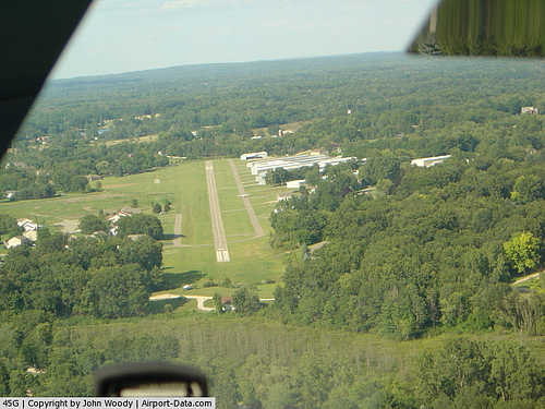 |
(Click on the photo to enlarge) |
|
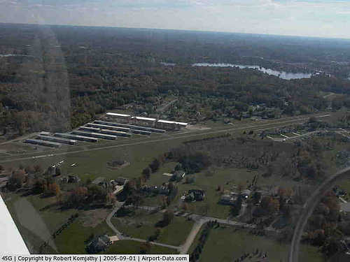 |
(Click on the photo to enlarge) |
Location & QuickFacts
| FAA Information Effective: | 2008-09-25 |
| Airport Identifier: | 45G |
| Airport Status: | Operational |
| Longitude/Latitude: | 083-46-42.7000W/42-34-11.3300N
-83.778528/42.569814 (Estimated) |
| Elevation: | 973 ft / 296.57 m (Surveyed) |
| Land: | 47 acres |
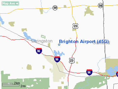
| From nearest city: | 3 nautical miles N of Brighton, MI |
| Location: | Livingston County, MI |
| Magnetic Variation: | 05W (1985) |
Owner & Manager
| Ownership: | Privately owned |
| Owner: | Brighton Arpt Association |
| Address: | 8664 Hyne Road
Brighton, MI 48114 |
| Phone number: | 810-599-0341 |
| Manager: | Peter Droncheff |
| Address: | 8664 Hyne Road
Brighton, MI 48114 |
| Phone number: | 810-599-0341 |
Airport Operations and Facilities
| Airport Use: | Open to public |
| Wind indicator: | Yes |
| Segmented Circle: | No |
| Control Tower: | No |
| Lighting Schedule: | RDO-CTL
ACTVT ROTG BCN, MIRL RY 04/22, & PAPI RY 22 - KEY CTAF 5X. |
| Beacon Color: | Clear-Green (lighted land airport) |
| Landing fee charge: | No |
| Sectional chart: | Detroit |
| Region: | AGL - Great Lakes |
| Boundary ARTCC: | ZOB - Cleveland |
| Tie-in FSS: | LAN - Lansing |
| FSS on Airport: | No |
| FSS Toll Free: | 1-800-WX-BRIEF |
| NOTAMs Facility: | LAN (NOTAM-d service avaliable) |
Airport Communications
Airport Services
Runway Information
Runway 04/22
| Dimension: | 3120 x 24 ft / 951.0 x 7.3 m |
| Surface: | ASPH, Fair Condition |
| Edge Lights: | Non-standard lighting system
NSTD MIRL LGTS LCTD 50 FT FM RWY EDGE, NSTD CONFIGURATION FOR THLD LIGHTS. |
| |
Runway 04 |
Runway 22 |
| Longitude: | 083-46-55.6790W | 083-46-29.7300W |
| Latitude: | 42-33-59.2670N | 42-34-23.3900N |
| Elevation: | 969.00 ft | 973.00 ft |
| Traffic Pattern: | Left | Left |
| Markings: | Basic, Fair Condition | Basic, Fair Condition |
| Crossing Height: | 0.00 ft | 29.00 ft |
| Displaced threshold: | 195.00 ft | 365.00 ft |
| VASI: | | 4-light PAPI on left side
NSTD (CLOSE) SPACING OF PAPI LIGHT BOXES. NSTD- MAY ONLY BE VSB ON SHORT FINAL APCH. FOR LOCAL USE ONLY. |
| Visual Glide Angle: | 0.00° | 3.60° |
| Obstruction: | 4 ft trees, 230.0 ft from runway, 20 ft left of centerline, 7:1 slope to clear
RWY 04 APCH RATIO 0:1 AT DSPLCD THLD, +50' TREES 100' R 0' DSTC.
RY 04 TREES 100 FT LEFT. | 52 ft trees, 700.0 ft from runway, 9:1 slope to clear
RWY 22 APCH RATIO 14:1 TO DSPLCD THLD, +34' TREES 490' DSTC, 105' L.
RY 22 PVT RD 160 FT DIST, PUB RD (+9 FT) 180 FT DIST. |
|
Radio Navigation Aids
| ID |
Type |
Name |
Ch |
Freq |
Var |
Dist |
| OZW | NDB | Howell | | 243.00 | 05W | 10.0 nm |
| TCU | NDB | Tecumseh | | 239.00 | 04W | 32.4 nm |
| G | NDB | Golf | | 398.00 | 05W | 37.9 nm |
| VQ | NDB | Cargl | | 230.00 | 05W | 38.7 nm |
| RYS | NDB | Grosse Ile | | 419.00 | 06W | 39.6 nm |
| QG | NDB | Windsor | | 353.00 | 06W | 43.2 nm |
| ADG | NDB | Adrian | | 278.00 | 06W | 44.1 nm |
| MTC | TACAN | Selfridge | 064X | | 06W | 42.0 nm |
| DXO | VOR/DME | Detroit | 081X | 113.40 | 06W | 28.2 nm |
| JXN | VOR/DME | Jackson | 033X | 109.60 | 05W | 35.5 nm |
| YQG | VOR/DME | Windsor | 085X | 113.80 | 06W | 46.3 nm |
| SVM | VORTAC | Salem | 090X | 114.30 | 03W | 12.7 nm |
| PSI | VORTAC | Pontiac | 047X | 111.00 | 03W | 13.4 nm |
| FNT | VORTAC | Flint | 116X | 116.90 | 06W | 23.9 nm |
| CRL | VORTAC | Carleton | 104X | 115.70 | 03W | 34.5 nm |
| LAN | VORTAC | Lansing | 045X | 110.80 | 05W | 41.6 nm |
| YIP | VOT | Willow Run | | 112.00 | | 23.2 nm |
| DTW | VOT | Detroit Met Wayne | | 109.80 | | 27.6 nm |
| DET | VOT | Detroit City | | 111.60 | | 35.2 nm |
Remarks
Images and information placed above are from
http://www.airport-data.com/airport/45G/
We thank them for the data!
| General Info
|
| Country |
United States
|
| State |
MICHIGAN
|
| FAA ID |
45G
|
| Latitude |
42-34-11.330N
|
| Longitude |
083-46-42.700W
|
| Elevation |
973 feet
|
| Near City |
BRIGHTON
|
We don't guarantee the information is fresh and accurate. The data may
be wrong or outdated.
For more up-to-date information please refer to other sources.
|
|


