 |
|
Branch County Memorial Airport |
| Branch County Memorial Airport |
| IATA: none – ICAO: KOEB – FAA LID: OEB |
| Summary |
| Airport type |
Public |
| Owner |
Branch County |
| Serves |
Coldwater, Michigan |
| Elevation AMSL |
959 ft / 292 m |
| Coordinates |
41°56′01″N 085°03′08″W / 41.93361°N 85.05222°W / 41.93361; -85.05222 |
| Runways |
| Direction |
Length |
Surface |
| ft |
m |
| 7/25 |
5,350 |
1,631 |
Asphalt |
| 4/22 |
3,500 |
1,067 |
Asphalt |
| 16/34 |
2,400 |
732 |
Turf |
| Statistics (2008) |
| Aircraft operations |
12,000 |
| Based aircraft |
22 |
| Source: Federal Aviation Administration |
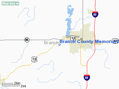
Branch County Memorial Airport (ICAO: KOEB, FAA LID: OEB) is a county-owned, public-use airport located three nautical miles (6 km) west of the central business district of Coldwater, a city in Branch County, Michigan, United States. According to the FAA's National Plan of Integrated Airport Systems for 2009–2013, it is categorized as a general aviation airport.
Although many U.S. airports use the same three-letter location identifier for the FAA and IATA, this airport is assigned OEB by the FAA and no designation from the IATA. Facilities and aircraft
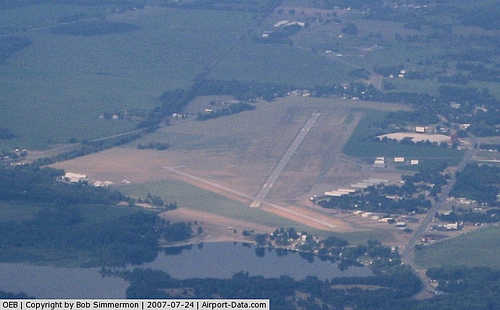
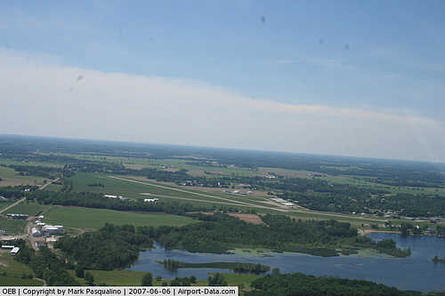
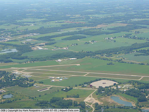
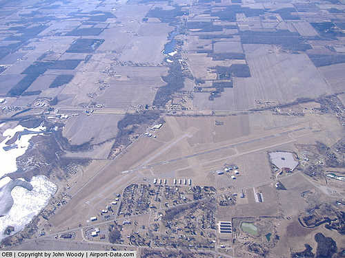
Branch County Memorial Airport covers an area of 290 acres (117 ha) at an elevation of 959 feet (292 m) above mean sea level. It has three runways: 7/25 and 4/22 have asphalt surfaces measuring 5,350 by 75 feet (1,631 x 23 m) and 3,500 by 75 feet (1,067 x 23 m) respectively; 16/34 has a turf surface measuring 2,400 by 190 feet (732 x 58 m). The airport is staffed irregularly.
For the 12-month period ending December 31, 2008, the airport had 12,000 general aviation aircraft operations, an average of 32 per day. At that time there were 22 aircraft based at this airport: 72.7% single-engine, 13.6% multi-engine, 4.5% jet, 4.5% helicopter and 4.5% ultralight.
Transit
The airport is accessible by road from US-12, and is close to M-86 and I-69.
The above content comes from Wikipedia and is published under free licenses – click here to read more.
|
 |
(Click on the photo to enlarge) |
|
 |
(Click on the photo to enlarge) |
|
 |
(Click on the photo to enlarge) |
|
 |
(Click on the photo to enlarge) |
Location & QuickFacts
| FAA Information Effective: | 2008-09-25 |
| Airport Identifier: | OEB |
| Airport Status: | Operational |
| Longitude/Latitude: | 085-03-08.2566W/41-56-00.8489N
-85.052294/41.933569 (Estimated) |
| Elevation: | 959 ft / 292.30 m (Surveyed) |
| Land: | 290 acres |
| From nearest city: | 3 nautical miles W of Coldwater, MI |
| Location: | Branch County, MI |
| Magnetic Variation: | 05W (2000) |
Owner & Manager
| Ownership: | Publicly owned |
| Owner: | Branch County |
| Address: | 31 Divison St
Coldwater, MI 49036 |
| Phone number: | 517-278-4301 |
| Manager: | Ron Dooley |
| Address: | 285 Cynthia Dr
Coldwater, MI 49036 |
| Phone number: | 517-279-7050
FOR ARPT MGR EVENINGS CALL 517-278-7145 |
Airport Operations and Facilities
| Airport Use: | Open to public |
| Wind indicator: | Yes |
| Segmented Circle: | Yes |
| Control Tower: | No |
| Lighting Schedule: | DUSK-DAWN
ACTVT MIRL RYS 04/22 & 07/25; REIL RY 25 - CTAF. |
| Beacon Color: | Clear-Green (lighted land airport) |
| Landing fee charge: | No |
| Sectional chart: | Chicago |
| Region: | AGL - Great Lakes |
| Boundary ARTCC: | ZAU - Chicago |
| Tie-in FSS: | LAN - Lansing |
| FSS on Airport: | No |
| FSS Toll Free: | 1-800-WX-BRIEF |
| NOTAMs Facility: | OEB (NOTAM-d service avaliable) |
| Federal Agreements: | NGY |
Airport Communications
| CTAF: | 122.700 |
| Unicom: | 122.700 |
Airport Services
| Fuel available: | 100LLA
24 HR SELF-SERVICE FUEL W/MAJOR CREDIT CARD. |
| Airframe Repair: | MAJOR |
| Power Plant Repair: | MAJOR |
| Bottled Oxygen: | NONE |
Runway Information
Runway 04/22
| Dimension: | 3500 x 75 ft / 1066.8 x 22.9 m |
| Surface: | ASPH, Good Condition |
| Weight Limit: | Single wheel: 18000 lbs. |
| Edge Lights: | Medium |
| |
Runway 04 |
Runway 22 |
| Longitude: | 085-03-06.0848W | 085-02-40.5182W |
| Latitude: | 41-55-51.6477N | 41-56-20.4668N |
| Elevation: | 956.00 ft | 955.00 ft |
| Alignment: | 34 | 127 |
| Traffic Pattern: | Left | Left |
| Markings: | Basic, Good Condition | Basic, Good Condition |
| Runway End Identifier: | No | No |
| Centerline Lights: | No | No |
| Touchdown Lights: | No | No |
| Obstruction: | 53 ft tree, 1260.0 ft from runway, 50 ft right of centerline, 20:1 slope to clear | 32 ft tree, 840.0 ft from runway, 125 ft left of centerline, 20:1 slope to clear |
|
Runway 07/25
| Dimension: | 5350 x 75 ft / 1630.7 x 22.9 m |
| Surface: | ASPH, Fair Condition |
| Weight Limit: | Single wheel: 20000 lbs. |
| Edge Lights: | Medium |
| |
Runway 07 |
Runway 25 |
| Longitude: | 085-03-50.8737W | 085-02-47.3347W |
| Latitude: | 41-55-46.3233N | 41-56-09.6126N |
| Elevation: | 956.00 ft | 954.00 ft |
| Alignment: | 64 | 127 |
| Traffic Pattern: | Left | Left |
| Markings: | Non-precision instrument, Fair Condition | Non-precision instrument, Fair Condition |
| Crossing Height: | 0.00 ft | 37.00 ft |
| VASI: | | 2-light PAPI on left side |
| Visual Glide Angle: | 0.00° | 3.00° |
| Runway End Identifier: | | Yes
REIL OTS INDEFLY. |
| Centerline Lights: | No | No |
| Obstruction: | 50 ft trees, 1200.0 ft from runway, 205 ft left of centerline, 20:1 slope to clear | 15 ft road, 380.0 ft from runway, 277 ft left of centerline, 12:1 slope to clear
APCH RATIO 25:1 AT RWY END. |
|
Runway 16/34
| Dimension: | 2400 x 190 ft / 731.5 x 57.9 m |
| Surface: | TURF, Good Condition |
| |
Runway 16 |
Runway 34 |
| Longitude: | 085-03-10.7890W | 085-03-00.9810W |
| Latitude: | 41-56-10.9510N | 41-55-48.4000N |
| Alignment: | 127 | 127 |
| Traffic Pattern: | Left | Left |
| Displaced threshold: | 595.00 ft | 0.00 ft |
| Runway End Identifier: | No | No |
| Centerline Lights: | No | No |
| Touchdown Lights: | No | No |
| Obstruction: | 52 ft trees, 445.0 ft from runway, 30 ft right of centerline, 8:1 slope to clear
RWY 16 APCH RATIO 20:1 AT DSPLCD THLD OVER 52 FT TREES, 1040 FT DSTC, 30 FT R. | 67 ft trees, 871.0 ft from runway, 148 ft right of centerline, 13:1 slope to clear
APCH RATIO 20:1 BASED ON STRAIGHT OUT. |
|
Radio Navigation Aids
| ID |
Type |
Name |
Ch |
Freq |
Var |
Dist |
| ANQ | NDB | Angola | | 347.00 | 05W | 17.7 nm |
| IRS | NDB | Sturgis | | 382.00 | 04W | 18.5 nm |
| HAI | NDB | Three Rivers | | 407.00 | 02W | 24.2 nm |
| BT | NDB | Batol | | 272.00 | 04W | 26.4 nm |
| BYN | NDB | Bryan | | 260.00 | 04W | 37.9 nm |
| ADG | NDB | Adrian | | 278.00 | 06W | 43.8 nm |
| USE | NDB | Fulton | | 375.00 | 05W | 45.6 nm |
| DFI | NDB | Defiance | | 246.00 | 05W | 45.7 nm |
| OLK | VOR | Wolf Lake | | 110.40 | 03W | 45.9 nm |
| LFD | VOR/DME | Litchfield | 049X | 111.20 | 05W | 15.0 nm |
| AZO | VOR/DME | Kalamazoo | 027X | 109.00 | 01W | 28.8 nm |
| JXN | VOR/DME | Jackson | 033X | 109.60 | 05W | 32.9 nm |
| ELX | VOR/DME | Keeler | 113X | 116.60 | 00E | 49.4 nm |
| BTL | VORTAC | Battle Creek | 031X | 109.40 | 02W | 24.3 nm |
| LAN | VORTAC | Lansing | 045X | 110.80 | 05W | 49.7 nm |
Remarks
- RYS 04/22 & 07/25 PLOWED WINTER MONTHS. CALL AMGR AT 517-278-7145 FOR CONDITIONS.
- FBO PHONE 517-278-6516.
- DEER ON & INVOF ARPT.
- GCO AVBL ON FREQ 121.725 THRU AZO CLEARANCE DELIVERY AND LAN AFSS.
- PREFERRED CALM WIND RY 25.
Images and information placed above are from
http://www.airport-data.com/airport/OEB/
We thank them for the data!
| General Info
|
| Country |
United States
|
| State |
MICHIGAN
|
| FAA ID |
OEB
|
| Latitude |
41-56-00.415N
|
| Longitude |
085-03-09.306W
|
| Elevation |
959 feet
|
| Near City |
COLDWATER
|
We don't guarantee the information is fresh and accurate. The data may
be wrong or outdated.
For more up-to-date information please refer to other sources.
|
|


