|
|
|
 |
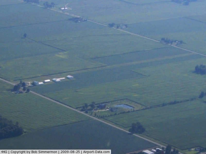
(Click on the photo to enlarge) |
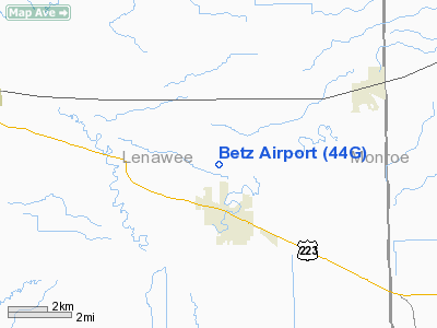
Location & QuickFacts
| FAA Information Effective: | 2008-09-25 |
| Airport Identifier: | 44G |
| Airport Status: | Operational |
| Longitude/Latitude: | 083-52-14.7880W/41-51-20.1730N
-83.870774/41.855604 (Estimated) |
| Elevation: | 691 ft / 210.62 m (Surveyed) |
| Land: | 7 acres |
| From nearest city: | 2 nautical miles N of Blissfield, MI |
| Location: | Lenawee County, MI |
| Magnetic Variation: | 05W (1985) |
Owner & Manager
| Ownership: | Privately owned |
| Owner: | Reta C. Betz |
| Address: | 4504 S. Blissfield Hwy
Blissfield, MI 49228 |
| Phone number: | 517-486-3667 |
| Manager: | Reta C. Betz |
| Address: | 4504 S. Blissfield Hwy
Blissfield, MI 49228 |
| Phone number: | 517-486-3667 |
Airport Operations and Facilities
| Airport Use: | Open to public |
| Wind indicator: | Yes |
| Segmented Circle: | No |
| Control Tower: | No |
| Landing fee charge: | No |
| Sectional chart: | Detroit |
| Region: | AGL - Great Lakes |
| Boundary ARTCC: | ZOB - Cleveland |
| Tie-in FSS: | LAN - Lansing |
| FSS on Airport: | No |
| FSS Toll Free: | 1-800-WX-BRIEF |
| NOTAMs Facility: | LAN (NOTAM-d service avaliable) |
Airport Communications
Airport Services
| Fuel available: | 100LL
FUEL AVBL BY PRIOR ARAINGEMENT; PHONE 517-486-3667. |
| Airframe Repair: | MINOR |
| Power Plant Repair: | MINOR |
| Bottled Oxygen: | NONE |
| Bulk Oxygen: | NONE |
Runway Information
Runway 09/27
| Dimension: | 2602 x 92 ft / 793.1 x 28.0 m |
| Surface: | TURF, Good Condition |
| Edge Lights: | Non-standard lighting system
NSTD LIRL ON ARPT NOT FOR PUBLIC USE PER OWNERS REQ; MKD WITH WHITE LGTS. |
| |
Runway 09 |
Runway 27 |
| Longitude: | 083-52-31.9200W | 083-51-57.5400W |
| Latitude: | 41-51-18.2000N | 41-51-18.2000N |
| Alignment: | 89 | 127 |
| Traffic Pattern: | Left | Left |
| Displaced threshold: | 415.00 ft | 390.00 ft |
| Runway End Identifier: | No | No |
| Centerline Lights: | No | No |
| Touchdown Lights: | No | No |
| Obstruction: | 15 ft road, 30.0 ft from runway, 2:1 slope to clear
RWY 09 APCH RATIO 29:1 AT DSPLCD THR. | 15 ft road, 45.0 ft from runway, 3:1 slope to clear
RWY 27 APCH RATIO 29:1 AT DSPLCD THLD. |
|
Radio Navigation Aids
| ID |
Type |
Name |
Ch |
Freq |
Var |
Dist |
| ADG | NDB | Adrian | | 278.00 | 06W | 9.3 nm |
| TCU | NDB | Tecumseh | | 239.00 | 04W | 10.9 nm |
| USE | NDB | Fulton | | 375.00 | 05W | 18.9 nm |
| BYN | NDB | Bryan | | 260.00 | 04W | 35.0 nm |
| RYS | NDB | Grosse Ile | | 419.00 | 06W | 35.3 nm |
| DFI | NDB | Defiance | | 246.00 | 05W | 40.1 nm |
| G | NDB | Golf | | 398.00 | 05W | 43.5 nm |
| FZI | NDB | Fostoria | | 379.00 | 05W | 45.4 nm |
| OZW | NDB | Howell | | 243.00 | 05W | 47.1 nm |
| PCW | NDB | Port Clinton | | 423.00 | 06W | 49.3 nm |
| PDR | NDB | Ottawa | | 233.00 | 05W | 49.8 nm |
| TOL | TACAN | Toledo | 072X | | 05W | 16.1 nm |
| VWV | VOR/DME | Waterville | 078X | 113.10 | 02W | 26.4 nm |
| DXO | VOR/DME | Detroit | 081X | 113.40 | 06W | 31.1 nm |
| JXN | VOR/DME | Jackson | 033X | 109.60 | 05W | 35.7 nm |
| LFD | VOR/DME | Litchfield | 049X | 111.20 | 05W | 41.9 nm |
| CRL | VORTAC | Carleton | 104X | 115.70 | 03W | 21.8 nm |
| SVM | VORTAC | Salem | 090X | 114.30 | 03W | 35.5 nm |
| YIP | VOT | Willow Run | | 112.00 | | 27.6 nm |
| DTW | VOT | Detroit Met Wayne | | 109.80 | | 31.8 nm |
Remarks
- ACFT PRKD EAST END ADJ TO RY ON NORH SIDE.
- SOFT IN SPRING.
- RY 27, +20 FT PLINE, 375 FM THLD.
- RY 09 - 3 FT DITCH 10 FT FM THLD.
- EXISTED PRIOR TO 1959.
Images and information placed above are from
http://www.airport-data.com/airport/44G/
We thank them for the data!
| General Info
|
| Country |
United States
|
| State |
MICHIGAN
|
| FAA ID |
44G
|
| Latitude |
41-51-20.173N
|
| Longitude |
083-52-14.788W
|
| Elevation |
691 feet
|
| Near City |
BLISSFIELD
|
We don't guarantee the information is fresh and accurate. The data may
be wrong or outdated.
For more up-to-date information please refer to other sources.
|
|