 |
|
Atlanta Municipal Airport |
| Atlanta Municipal Airport |
| IATA: none – ICAO: none – FAA LID: Y93 |
| Summary |
| Airport type |
Public |
| Owner |
Briley & Avery Townships |
| Serves |
Atlanta, Michigan |
| Elevation AMSL |
875 ft / 267 m |
| Coordinates |
44°59′47″N 84°07′37″W / 44.99639°N 84.12694°W / 44.99639; -84.12694 |
| Runways |
| Direction |
Length |
Surface |
| ft |
m |
| 5/23 |
3,000 |
914 |
Asphalt |
| 13/31 |
3,223 |
982 |
Turf |
| Statistics (2006) |
| Aircraft operations |
1,323 |
| Based aircraft |
11 |
| Source: Federal Aviation Administration |
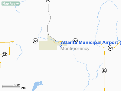
Atlanta Municipal Airport (FAA LID: Y93) is a public airport located one mile (2 km) southeast of the central business district of Atlanta, in Montmorency County, Michigan, United States. The airport is owned by Briley Township and Avery Township. It is located at coordinates 44°59′47″N 84°07′37″W / 44.99639°N 84.12694°W / 44.99639; -84.12694 is accessible by road from Airport Road, located near M-32, and M-33.
Facilities and aircraft
Atlanta Municipal Airport covers an area of 172 acres (70 ha) which contains two runways: 5/23 with an asphalt surface measuring 3,000 by 60 feet (914 by 18 m) and 13/31 with a turf surface measuring 3,223 by 100 feet (982 by 30 m). Runway 13/31 is closed from November through April, and also when snow-covered. The airport is staffed upon request.
For the 12-month period ending December 31, 2006, the general aviation airport had 1,323 aircraft operations, an average of 110 per month. There are 11 single-engine aircraft based at this airport.
The above content comes from Wikipedia and is published under free licenses – click here to read more.
Location & QuickFacts
| FAA Information Effective: | 2008-09-25 |
| Airport Identifier: | Y93 |
| Airport Status: | Operational |
| Longitude/Latitude: | 084-08-00.0120W/45-00-00.0300N
-84.133337/45.000008 (Estimated) |
| Elevation: | 875 ft / 266.70 m (Estimated) |
| Land: | 172 acres |
| From nearest city: | 1 nautical miles SE of Atlanta, MI |
| Location: | Montmorency County, MI |
| Magnetic Variation: | 06W (1985) |
Owner & Manager
| Ownership: | Publicly owned |
| Owner: | Briley & Avery Twps |
| Address: | P O Box 322
Atlanta, MI 49709 |
| Phone number: | 989-785-4050
BRILEY TWP OFC. ALSO, HARRY DICE 989-785-3236 |
| Manager: | Donald Marlatt |
| Address: | P.o. Box 322, 7570 M-32
Atlanta, MI 49709 |
| Phone number: | 989-785-4748 |
Airport Operations and Facilities
| Airport Use: | Open to public |
| Wind indicator: | Yes |
| Segmented Circle: | Yes |
| Control Tower: | No |
| Lighting Schedule: | RDO-CTL
ACTVT LIRL RYS 13/31 & 05/23, PAPI RY 23 - CTAF. |
| Landing fee charge: | No |
| Sectional chart: | Lake Huron |
| Region: | AGL - Great Lakes |
| Boundary ARTCC: | ZMP - Minneapolis |
| Tie-in FSS: | LAN - Lansing |
| FSS on Airport: | No |
| FSS Toll Free: | 1-800-WX-BRIEF |
| NOTAMs Facility: | LAN (NOTAM-d service avaliable) |
| Federal Agreements: | N |
Airport Communications
Airport Services
| Fuel available: | 100LL |
| Airframe Repair: | NONE |
| Power Plant Repair: | NONE |
| Bottled Oxygen: | NONE |
| Bulk Oxygen: | NONE |
Runway Information
Runway 05/23
| Dimension: | 3000 x 60 ft / 914.4 x 18.3 m |
| Surface: | ASPH, Good Condition |
| Edge Lights: | Low
LIRL OPERATES JUN THRU SEP. OTS INDEFLY. |
| |
Runway 05 |
Runway 23 |
| Longitude: | 084-08-15.1400W | 084-07-44.6000W |
| Latitude: | 44-59-48.7100N | 45-00-08.9100N |
| Elevation: | 875.00 ft | 875.00 ft |
| Traffic Pattern: | Left | Left |
| Markings: | Basic, Good Condition | Basic, Good Condition |
| Crossing Height: | 0.00 ft | 22.00 ft |
| Displaced threshold: | 1230.00 ft | 370.00 ft |
| VASI: | | 2-light PAPI on left side |
| Visual Glide Angle: | 0.00° | 4.00° |
| Obstruction: | 80 ft trees, 392.0 ft from runway, 135 ft left of centerline, 3:1 slope to clear
APCH RATIO 20:1 AT DSPLCD THLD. | 20 ft trees, 400.0 ft from runway, 125 ft left of centerline, 10:1 slope to clear
APCH RATIO 34:1 AT DSPLCD THLD.OVR +70 FT TREES, 2380 FT FM DSPLCD THR. 0 B. |
|
Runway 13/31
| Dimension: | 3223 x 100 ft / 982.4 x 30.5 m |
| Surface: | TURF, Fair Condition |
| Edge Lights: | Low
LIRL OPERATES JUN THRU SEP. OTS INDEFLY. |
| |
Runway 13 |
Runway 31 |
| Longitude: | 084-08-17.9200W | 084-07-43.5900W |
| Latitude: | 45-00-10.6900N | 44-59-50.2500N |
| Elevation: | 875.00 ft | 875.00 ft |
| Traffic Pattern: | Left | Left |
| Displaced threshold: | 758.00 ft | 569.00 ft |
| Obstruction: | 50 ft trees, 50.0 ft from runway, 120 ft left of centerline
APCH RATIO 20:1 AT DSPLCD THLD. | 51 ft trees, 204.0 ft from runway, 110 ft right of centerline, 4:1 slope to clear
APCH RATIO 20:1 AT DSPLCD THLD. |
|
Radio Navigation Aids
| ID |
Type |
Name |
Ch |
Freq |
Var |
Dist |
| PZQ | NDB | Rogers City | | 215.00 | 07W | 27.7 nm |
| GYG | NDB | Grayling | | 359.00 | 06W | 33.2 nm |
| BFA | NDB | Boyne Falls | | 263.00 | 06W | 34.9 nm |
| BHW | NDB | Hardwood | | 236.00 | 06W | 45.2 nm |
| CXK | NDB | Clam Lake | | 251.00 | 05W | 47.5 nm |
| CGG | VOR | Grayling | | 109.80 | 06W | 31.8 nm |
| GLR | VOR/DME | Gaylord | 029X | 109.20 | 06W | 24.3 nm |
| HTL | VOR/DME | Houghton Lake | 053X | 111.60 | 05W | 44.8 nm |
| BXZ | VOR/DME | West Branch | 079X | 113.20 | 06W | 45.6 nm |
| ASP | VOR/DME | Au Sable | 108X | 116.10 | 07W | 45.7 nm |
| APN | VORTAC | Alpena | 025X | 108.80 | 07W | 25.0 nm |
| PLN | VORTAC | Pellston | 055X | 111.80 | 06W | 44.0 nm |
Remarks
- FOR WINTER COND/SNOW REMOVAL RY 05/23 CONFIRM PRIOR TO USE; CALL 989-785-4724; NO SNOW REMOVAL RY 13/31.
- RY 13/31 CLSD NOV-APR & WHEN SNOW COVERED.
- E111 NON-COMPLIANCE WITH FAR 157.
Images and information placed above are from
http://www.airport-data.com/airport/Y93/
We thank them for the data!
| General Info
|
| Country |
United States
|
| State |
MICHIGAN
|
| FAA ID |
Y93
|
| Latitude |
45-00-00.030N
|
| Longitude |
084-08-00.012W
|
| Elevation |
875 feet
|
| Near City |
ATLANTA
|
We don't guarantee the information is fresh and accurate. The data may
be wrong or outdated.
For more up-to-date information please refer to other sources.
|
|


