 |
|
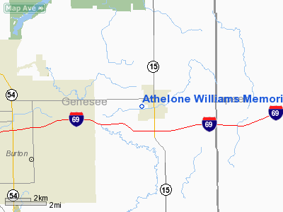
Athelone Williams Memorial Airport |
Location & QuickFacts
| FAA Information Effective: | 2008-09-25 |
| Airport Identifier: | 6G0 |
| Airport Status: | Operational |
| Longitude/Latitude: | 083-31-46.8230W/43-01-44.8970N
-83.529673/43.029138 (Estimated) |
| Elevation: | 780 ft / 237.74 m (Surveyed) |
| Land: | 37 acres |
| From nearest city: | 1 nautical miles W of Davison, MI |
| Location: | Genesee County, MI |
| Magnetic Variation: | 07W (2000) |
Owner & Manager
| Ownership: | Publicly owned |
| Owner: | Davison Township |
| Address: | 1280 N Irish Rd
Davison, MI 48423 |
| Phone number: | 810-653-4156 |
| Manager: | Randall V. Stewart |
| Address: | 1280 N. Irish Rd
Davison, MI 48423 |
| Phone number: | 810-653-4156 |
Airport Operations and Facilities
| Airport Use: | Open to public |
| Wind indicator: | Yes |
| Segmented Circle: | No |
| Control Tower: | No |
| Lighting Schedule: | DUSK-DAWN |
| Landing fee charge: | No |
| Sectional chart: | Detroit |
| Region: | AGL - Great Lakes |
| Boundary ARTCC: | ZOB - Cleveland |
| Tie-in FSS: | LAN - Lansing |
| FSS on Airport: | No |
| FSS Toll Free: | 1-800-WX-BRIEF |
| NOTAMs Facility: | LAN (NOTAM-d service avaliable) |
Airport Communications
Airport Services
| Airframe Repair: | NONE |
| Power Plant Repair: | NONE |
Runway Information
Runway 08/26
| Dimension: | 3469 x 40 ft / 1057.4 x 12.2 m |
| Surface: | ASPH, Fair Condition
RY 8/26 SFC CRACKED, PEELING, ROUGH AND HAS LOOSE ASPHALT. |
| Edge Lights: | Non-standard lighting system
NSTD MIRL; LGTS LOCATED 20 FT FROM RY EDGE. |
| |
Runway 08 |
Runway 26 |
| Longitude: | 083-32-10.1280W | 083-31-23.5760W |
| Latitude: | 43-01-43.5170N | 43-01-46.3060N |
| Elevation: | 776.00 ft | 780.00 ft |
| Alignment: | 85 | 127 |
| Traffic Pattern: | Left | Left |
| Markings: | Basic, Fair Condition
RY 8/26 MARKINGS FADED. | Basic, Fair Condition
RY 8/26 MARKINGS FADED. |
| Displaced threshold: | 170.00 ft | 368.00 ft |
| Runway End Identifier: | No | No |
| Centerline Lights: | No | No |
| Touchdown Lights: | No | No |
| Obstruction: | 30 ft pline, 201.0 ft from runway, 100 ft left of centerline
08/26 +30' PLINE PARALLELS RY ENTIRE LENGTH 100' NORTH.
RWY 08 APCH RATIO 0:1 AT DSPLCD THR; +30 FT PLINE AT THLD 100 FT L.
RWY 08 +30 FT P-LINE 100 FT L 0 FT DSTC; +16 FT ROAD 160 FT, BRUSH, TREES. | 30 ft pline, 201.0 ft from runway, 100 ft right of centerline
APCH RATIO 0:1 AT DSPLCD THR; +30 FT TREES 80 FT R.
+30 FT PLINE 100 FT R 0 FT DSTC; 5' FENCE 87' DSTC. |
|
Radio Navigation Aids
| ID |
Type |
Name |
Ch |
Freq |
Var |
Dist |
| HYX | NDB | Browne | | 385.00 | 06W | 28.1 nm |
| OZW | NDB | Howell | | 243.00 | 05W | 31.2 nm |
| VQ | NDB | Cargl | | 230.00 | 05W | 47.8 nm |
| MTC | TACAN | Selfridge | 064X | | 06W | 39.7 nm |
| MBS | VOR/DME | Saginaw | 076X | 112.90 | 03W | 38.6 nm |
| DXO | VOR/DME | Detroit | 081X | 113.40 | 06W | 49.6 nm |
| FNT | VORTAC | Flint | 116X | 116.90 | 06W | 10.3 nm |
| PSI | VORTAC | Pontiac | 047X | 111.00 | 03W | 19.7 nm |
| SVM | VORTAC | Salem | 090X | 114.30 | 03W | 37.4 nm |
| ECK | VORTAC | Peck | 087X | 114.00 | 07W | 38.1 nm |
| DET | VOT | Detroit City | | 111.60 | | 43.8 nm |
| YIP | VOT | Willow Run | | 112.00 | | 47.8 nm |
| DTW | VOT | Detroit Met Wayne | | 109.80 | | 48.7 nm |
Remarks
- RY 08/26 -4 FT DRAINAGE DITCH 60 FT L/R OF RY CNTRLN ALONG ENTIRE LENGTH.
- STD L PAT: BASE-CROSSWIND LEGS - 1 MI E.
Images and information placed above are from
http://www.airport-data.com/airport/6G0/
We thank them for the data!
| General Info
|
| Country |
United States
|
| State |
MICHIGAN
|
| FAA ID |
6G0
|
| Latitude |
43-01-44.897N
|
| Longitude |
083-31-46.823W
|
| Elevation |
780 feet
|
| Near City |
DAVISON
|
We don't guarantee the information is fresh and accurate. The data may
be wrong or outdated.
For more up-to-date information please refer to other sources.
|
|


