 |
|
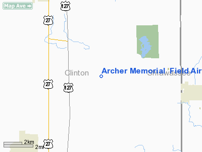
Archer Memorial Field Airport |
Location & QuickFacts
| FAA Information Effective: | 2008-09-25 |
| Airport Identifier: | 2S3 |
| Airport Status: | Operational |
| Longitude/Latitude: | 084-28-19.9250W/42-54-25.1150N
-84.472201/42.906976 (Estimated) |
| Elevation: | 794 ft / 242.01 m (Surveyed) |
| Land: | 12 acres |
| From nearest city: | 7 nautical miles SE of St Johns, MI |
| Location: | Clinton County, MI |
| Magnetic Variation: | 05W (1985) |
Owner & Manager
| Ownership: | Privately owned |
| Owner: | Beverly Archer |
| Address: | 7666 Linton Rd
St Johns, MI 48879 |
| Phone number: | 517-651-5151 |
| Manager: | Gayland L. Tennis |
| Address: | 4100 E Howe Rd
Bath, MI 48808 |
| Phone number: | 517-641-6192 |
Airport Operations and Facilities
| Airport Use: | Open to public |
| Wind indicator: | Yes |
| Segmented Circle: | Yes |
| Control Tower: | No |
| Landing fee charge: | No |
| Sectional chart: | Detroit |
| Region: | AGL - Great Lakes |
| Traffic Pattern Alt: | 806 ft |
| Boundary ARTCC: | ZOB - Cleveland |
| Tie-in FSS: | LAN - Lansing |
| FSS on Airport: | No |
| FSS Toll Free: | 1-800-WX-BRIEF |
| NOTAMs Facility: | LAN (NOTAM-d service avaliable) |
Airport Communications
| CTAF: | 122.900 |
| Unicom: | 122.800 |
Airport Services
| Power Plant Repair: | NONE |
| Bottled Oxygen: | NONE |
| Bulk Oxygen: | NONE |
Runway Information
Runway 17/35
| Dimension: | 2496 x 110 ft / 760.8 x 33.5 m |
| Surface: | TURF, Good Condition |
| |
Runway 17 |
Runway 35 |
| Traffic Pattern: | Left | Left |
| Displaced threshold: | 0.00 ft | 1145.00 ft |
| Runway End Identifier: | No | No |
| Centerline Lights: | No | No |
| Touchdown Lights: | No | No |
| Obstruction: | 110 ft trees, 2420.0 ft from runway, 55 ft left of centerline, 22:1 slope to clear | 50 ft trees, 0.0 ft from runway, 106 ft right of centerline
RWY 35 APCH RATIO STRAIGHT OUT FROM DSPLD THLD IS 20:1 BASED ON 90 FT TREE, 447 FT DSTC, 55L |
|
Radio Navigation Aids
| ID |
Type |
Name |
Ch |
Freq |
Var |
Dist |
| OZW | NDB | Howell | | 243.00 | 05W | 27.0 nm |
| AMN | NDB | Alma | | 329.00 | 05W | 28.6 nm |
| HYX | NDB | Browne | | 385.00 | 06W | 41.5 nm |
| BT | NDB | Batol | | 272.00 | 04W | 45.4 nm |
| JXN | VOR/DME | Jackson | 033X | 109.60 | 05W | 38.9 nm |
| MBS | VOR/DME | Saginaw | 076X | 112.90 | 03W | 41.3 nm |
| MOP | VOR/DME | Mount Pleasant | 043X | 110.60 | 05W | 44.6 nm |
| GRR | VOR/DME | Grand Rapids | 106Y | 115.95 | 04W | 45.7 nm |
| LAN | VORTAC | Lansing | 045X | 110.80 | 05W | 15.1 nm |
| FNT | VORTAC | Flint | 116X | 116.90 | 06W | 32.1 nm |
| PSI | VORTAC | Pontiac | 047X | 111.00 | 03W | 43.2 nm |
| SVM | VORTAC | Salem | 090X | 114.30 | 03W | 49.0 nm |
| BTL | VORTAC | Battle Creek | 031X | 109.40 | 02W | 49.8 nm |
Remarks
- NO SNOW REMOVAL.
- PRVDD CLEAR 20:1 APCHS, CLEAR OBSTACLE FREE ZONE AND AREA IS MARKED.
Images and information placed above are from
http://www.airport-data.com/airport/2S3/
We thank them for the data!
We don't guarantee the information is fresh and accurate. The data may
be wrong or outdated.
For more up-to-date information please refer to other sources.
|
|


