 |
|
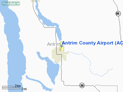
| Antrim County Airport |
| IATA: ACB – ICAO: KACB – FAA LID: ACB |
| Summary |
| Airport type |
Public |
| Owner |
Antrim County |
| Serves |
Bellaire, Michigan |
| Elevation AMSL |
623 ft / 190 m |
| Coordinates |
44°59′19″N 085°11′54″W / 44.98861°N 85.19833°W / 44.98861; -85.19833 |
| Runways |
| Direction |
Length |
Surface |
| ft |
m |
| 2/20 |
5,000 |
1,524 |
Asphalt |
| Statistics (2006) |
| Aircraft operations |
11,516 |
| Source: Federal Aviation Administration |
Antrim County Airport (IATA: ACB, ICAO: KACB, FAA LID: ACB) is a county-owned public-use airport located one mile (2 km) northeast of the central business district of Bellaire, a village in Antrim County, Michigan, United States.
Facilities and aircraft
Antrim County Airport covers an area of 363 acres (147 ha) which contains one asphalt paved runway (2/20) measuring 5,000 x 100 ft (1,524 x 30 m). For the 12-month period ending December 31, 2006, the airport had 11,516 aircraft operations, an average of 31 per day: 99% general aviation and 1% military.
The above content comes from Wikipedia and is published under free licenses – click here to read more.
|
 |
(Click on the photo to enlarge) |
Location & QuickFacts
| FAA Information Effective: | 2008-09-25 |
| Airport Identifier: | ACB |
| Airport Status: | Operational |
| Longitude/Latitude: | 085-11-54.0780W/44-59-18.8740N
-85.198355/44.988576 (Estimated) |
| Elevation: | 623 ft / 189.89 m (Surveyed) |
| Land: | 363 acres |
| From nearest city: | 1 nautical miles NE of Bellaire, MI |
| Location: | Antrim County, MI |
| Magnetic Variation: | 05W (1990) |
Owner & Manager
| Ownership: | Publicly owned |
| Owner: | Antrim County |
| Address: | Po Box 520, 230 E Cayuga
Bellaire, MI 49615 |
| Phone number: | 231-533-6353 |
| Manager: | John C. Strehl |
| Address: | 3366a Derenzy Rd
Bellaire, MI 49615 |
| Phone number: | 231-533-8524 |
Airport Operations and Facilities
| Airport Use: | Open to public |
| Wind indicator: | Yes
LGTD SUPPLEMENTAL WIND CONES EACH END RY 02 & 20. |
| Segmented Circle: | Yes |
| Control Tower: | No |
| Lighting Schedule: | DUSK-DAWN
MIRL RY 02/20 PRESET; TO INCR INTST & ACTVT REIL RY 02/20 - CTAF. |
| Beacon Color: | Clear-Green (lighted land airport) |
| Landing fee charge: | Yes
LNDG FEE APPLIES TO TURBINE & JET ENGINE ACFT; WAIVED WITH 100 GALLON FUEL PURCHASE. |
| Sectional chart: | Green Bay |
| Region: | AGL - Great Lakes |
| Boundary ARTCC: | ZMP - Minneapolis |
| Tie-in FSS: | LAN - Lansing |
| FSS on Airport: | No |
| FSS Toll Free: | 1-800-WX-BRIEF |
| NOTAMs Facility: | ACB (NOTAM-d service avaliable) |
| Federal Agreements: | NGY |
Airport Communications
| CTAF: | 122.700 |
| Unicom: | 122.700 |
Airport Services
| Fuel available: | 100LLA
FOR FUEL OTHER TIMES CALL 231-536-7017. |
| Airframe Repair: | NONE |
| Power Plant Repair: | NONE |
| Bottled Oxygen: | NONE |
| Bulk Oxygen: | NONE |
Runway Information
Runway 02/20
| Dimension: | 5000 x 100 ft / 1524.0 x 30.5 m |
| Surface: | ASPH, Fair Condition |
| Weight Limit: | Single wheel: 38000 lbs.
Dual wheel: 55000 lbs. |
| Edge Lights: | Medium |
| |
Runway 02 |
Runway 20 |
| Longitude: | 085-12-04.4970W | 085-11-43.6570W |
| Latitude: | 44-58-55.3220N | 44-59-42.4260N |
| Elevation: | 622.00 ft | 618.00 ft |
| Alignment: | 17 | 127 |
| Traffic Pattern: | Left | Left |
| Markings: | Precision instrument, Fair Condition | Precision instrument, Fair Condition |
| Crossing Height: | 42.00 ft | 46.00 ft |
| VASI: | 4-light PAPI on left side | 4-light PAPI on left side |
| Visual Glide Angle: | 3.00° | 3.25° |
| Runway End Identifier: | Yes | Yes |
| Centerline Lights: | No | No |
| Touchdown Lights: | No | No |
| Obstruction: | 65 ft tree, 1650.0 ft from runway, 22:1 slope to clear | 89 ft trees, 2895.0 ft from runway, 384 ft left of centerline, 30:1 slope to clear |
|
Radio Navigation Aids
| ID |
Type |
Name |
Ch |
Freq |
Var |
Dist |
| CXK | NDB | Clam Lake | | 251.00 | 05W | 5.6 nm |
| BFA | NDB | Boyne Falls | | 263.00 | 06W | 15.9 nm |
| TV | NDB | Gwenn | | 365.00 | 05W | 18.2 nm |
| CVX | NDB | Charlevoix | | 392.00 | 05W | 19.1 nm |
| GYG | NDB | Grayling | | 359.00 | 06W | 21.3 nm |
| CAD | NDB | Cadillac | | 269.00 | 04W | 43.9 nm |
| SJX | NDB | St James | | 382.00 | 05W | 45.0 nm |
| CGG | VOR | Grayling | | 109.80 | 06W | 27.2 nm |
| GLR | VOR/DME | Gaylord | 029X | 109.20 | 06W | 21.0 nm |
| HTL | VOR/DME | Houghton Lake | 053X | 111.60 | 05W | 44.2 nm |
| TVC | VORTAC | Traverse City | 093X | 114.60 | 02W | 24.4 nm |
| PLN | VORTAC | Pellston | 055X | 111.80 | 06W | 44.7 nm |
Remarks
- BIRDS ON & INVOF ARPT.
- GCO AVBL ON FREQ 121.725 THRU MINNEAPOLIS ARTCC CD & FLT SVCS.
- FOR ACFT MAINT RPRS CALL 1-800-959-1829.
- SNOW REMOVAL EQUIP ON RY & TWYS DURG WINTER MONTHS.
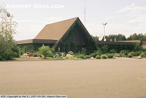
Images and information placed above are from
http://www.airport-data.com/airport/ACB/
We thank them for the data!
| General Info
|
| Country |
United States
|
| State |
MICHIGAN
|
| FAA ID |
ACB
|
| Latitude |
44-59-18.874N
|
| Longitude |
085-11-54.078W
|
| Elevation |
623 feet
|
| Near City |
BELLAIRE
|
We don't guarantee the information is fresh and accurate. The data may
be wrong or outdated.
For more up-to-date information please refer to other sources.
|
|


