 |
|
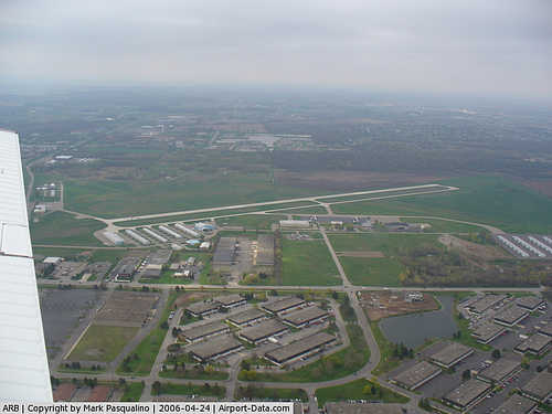
Ann Arbor Municipal Airport |
| Ann Arbor Municipal Airport |
 |
| IATA: ARB – ICAO: KARB – FAA LID: ARB |
| Summary |
| Airport type |
Public |
| Operator |
City |
| Serves |
Ann Arbor, Michigan |
| Elevation AMSL |
839 ft / 256 m |
| Coordinates |
42°13′22.74″N 83°44′44.18″W / 42.2229833°N 83.7456056°W / 42.2229833; -83.7456056 |
| Runways |
| Direction |
Length |
Surface |
| ft |
m |
| 6/24 |
3,500 |
1,067 |
Concrete |
| 12/30 |
2,750 |
838 |
Turf |
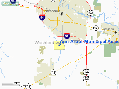
FAA airport diagram Ann Arbor Municipal Airport (IATA: ARB, ICAO: KARB, FAA LID: ARB) is a general aviation airport located 3 miles (5 km) south of the city of Ann Arbor in Washtenaw County, Michigan, USA.
The airport has an operating control tower which is operated by the FAA. The airport is located in FAA Class "D" airspace. There are 141 aircraft based at the airport, and it handles around 65,000 operations a year.
Facilities
Ann Arbor Municipal Airport covers 837 acres (3.39 km) and has two runways:
- Runway 6/24: 3,500 x 75 ft (1,067 x 23 m), Surface: Concrete
- Runway 12/30: 2,750 x 110 ft (838 x 34 m), Surface: Turf
The above content comes from Wikipedia and is published under free licenses – click here to read more.
|
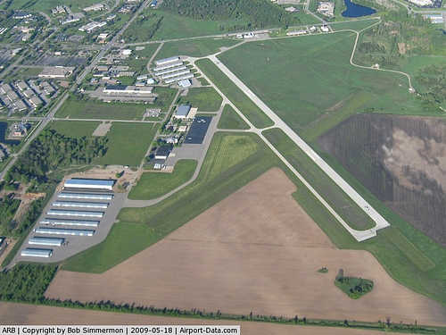 |
(Click on the photo to enlarge) |
|
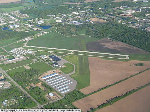 |
(Click on the photo to enlarge) |
|
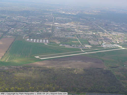 |
(Click on the photo to enlarge) |
|
 |
(Click on the photo to enlarge) |
Location & QuickFacts
| FAA Information Effective: | 2008-09-25 |
| Airport Identifier: | ARB |
| Airport Status: | Operational |
| Longitude/Latitude: | 083-44-44.1860W/42-13-22.7410N
-83.745607/42.222984 (Estimated) |
| Elevation: | 839 ft / 255.73 m (Estimated) |
| Land: | 837 acres |
| From nearest city: | 3 nautical miles S of Ann Arbor, MI |
| Location: | Washtenaw County, MI |
| Magnetic Variation: | 05W (1985) |
Owner & Manager
| Ownership: | Publicly owned |
| Owner: | Roger W. Fraser |
| Address: | 100 N, Fifth Ave
Ann Arbor, MI 48104 |
| Phone number: | 734-994-2650 |
| Manager: | Matthew Kulhanek |
| Address: | 100 N, Fifth Ave, P.o. Box 8647
Ann Arbor, MI 48107-8647 |
| Phone number: | 734-994-9124 |
Airport Operations and Facilities
| Airport Use: | Open to public |
| Wind indicator: | Yes |
| Segmented Circle: | Yes |
| Control Tower: | Yes |
| Lighting Schedule: | DUSK-DAWN
WHEN ATCT CLSD ACTVT ODALS RY 24 - CTAF. |
| Beacon Color: | Clear-Green (lighted land airport) |
| Sectional chart: | Detroit |
| Region: | AGL - Great Lakes |
| Boundary ARTCC: | ZOB - Cleveland |
| Tie-in FSS: | LAN - Lansing |
| FSS on Airport: | No |
| FSS Toll Free: | 1-800-WX-BRIEF |
| NOTAMs Facility: | ARB (NOTAM-d service avaliable) |
| Federal Agreements: | NGY |
Airport Communications
| CTAF: | 120.300 |
| Unicom: | 123.000 |
Airport Services
| Fuel available: | 100LLA |
| Airframe Repair: | MAJOR |
| Power Plant Repair: | MAJOR |
| Bottled Oxygen: | HIGH/LOW |
| Bulk Oxygen: | HIGH/LOW |
Runway Information
Runway 06/24
| Dimension: | 3505 x 75 ft / 1068.3 x 22.9 m |
| Surface: | CONC, Fair Condition |
| Surface Treatment: | Saw-cut or plastic Grooved |
| Weight Limit: | Single wheel: 20000 lbs. |
| Edge Lights: | Medium |
| |
Runway 06 |
Runway 24 |
| Longitude: | 083-45-00.3829W | 083-44-22.4468W |
| Latitude: | 42-13-12.8777N | 42-13-32.9683N |
| Elevation: | 831.00 ft | 826.00 ft |
| Alignment: | 55 | 127 |
| Traffic Pattern: | Left | Left |
| Markings: | Non-precision instrument, Fair Condition | Non-precision instrument, Fair Condition |
| Crossing Height: | 0.00 ft | 20.00 ft |
| VASI: | 4-light PAPI on left side | 2-box on left side |
| Visual Glide Angle: | 0.00° | 3.00° |
| Approach lights: | | ODALS |
| Runway End Identifier: | Yes | |
| Centerline Lights: | No | No |
| Touchdown Lights: | No | No |
| Obstruction: | 33 ft trees, 924.0 ft from runway, 370 ft left of centerline, 21:1 slope to clear | 59 ft trees, 1500.0 ft from runway, 22:1 slope to clear |
|
Runway 12/30
| Dimension: | 2750 x 110 ft / 838.2 x 33.5 m |
| Surface: | TURF, Fair Condition |
| |
Runway 12 |
Runway 30 |
| Longitude: | 083-45-03.2810W | 083-44-31.7850W |
| Latitude: | 42-13-29.8730N | 42-13-15.1410N |
| Traffic Pattern: | Left | Left |
| Runway End Identifier: | No | No |
| Centerline Lights: | No | No |
| Touchdown Lights: | No | No |
| Obstruction: | 33 ft trees, 990.0 ft from runway, 30:1 slope to clear | 39 ft trees, 780.0 ft from runway, 20:1 slope to clear |
|
Radio Navigation Aids
| ID |
Type |
Name |
Ch |
Freq |
Var |
Dist |
| TCU | NDB | Tecumseh | | 239.00 | 04W | 12.7 nm |
| ADG | NDB | Adrian | | 278.00 | 06W | 25.9 nm |
| OZW | NDB | Howell | | 243.00 | 05W | 26.9 nm |
| RYS | NDB | Grosse Ile | | 419.00 | 06W | 27.4 nm |
| G | NDB | Golf | | 398.00 | 05W | 31.1 nm |
| VQ | NDB | Cargl | | 230.00 | 05W | 36.1 nm |
| QG | NDB | Windsor | | 353.00 | 06W | 39.4 nm |
| USE | NDB | Fulton | | 375.00 | 05W | 40.8 nm |
| TOL | TACAN | Toledo | 072X | | 05W | 37.9 nm |
| MTC | TACAN | Selfridge | 064X | | 06W | 46.8 nm |
| DXO | VOR/DME | Detroit | 081X | 113.40 | 06W | 16.9 nm |
| JXN | VOR/DME | Jackson | 033X | 109.60 | 05W | 31.8 nm |
| YQG | VOR/DME | Windsor | 085X | 113.80 | 06W | 40.8 nm |
| LFD | VOR/DME | Litchfield | 049X | 111.20 | 05W | 46.5 nm |
| VWV | VOR/DME | Waterville | 078X | 113.10 | 02W | 46.6 nm |
| SVM | VORTAC | Salem | 090X | 114.30 | 03W | 13.0 nm |
| CRL | VORTAC | Carleton | 104X | 115.70 | 03W | 16.6 nm |
| PSI | VORTAC | Pontiac | 047X | 111.00 | 03W | 30.2 nm |
| FNT | VORTAC | Flint | 116X | 116.90 | 06W | 44.7 nm |
| YIP | VOT | Willow Run | | 112.00 | | 10.0 nm |
| DTW | VOT | Detroit Met Wayne | | 109.80 | | 16.9 nm |
| DET | VOT | Detroit City | | 111.60 | | 34.2 nm |
Remarks
- BIRDS ON & INVOF ARPT.
- WHEN ATCT CLSD CONFIRM SNOW REMOVAL OPNS & WINTER CONDS - CTAF.
- RUNUP AREA TO RY 24 & FIRST 200 FT OF PARALLEL TWY FM THE RUNUP AREA OF RY 24 NOT VISIBLE & UNCONTROLLED BY ATCT.
- NO SNOW REMOVAL FOR RY 12/30.
- 24 HR RESTROOMS LCTD IN Q-ROW NW HANGARS, COMBINATION 13455.
Images and information placed above are from
http://www.airport-data.com/airport/ARB/
We thank them for the data!
| General Info
|
| Country |
United States
|
| State |
MICHIGAN
|
| FAA ID |
ARB
|
| Latitude |
42-13-22.741N
|
| Longitude |
083-44-44.186W
|
| Elevation |
839 feet
|
| Near City |
ANN ARBOR
|
We don't guarantee the information is fresh and accurate. The data may
be wrong or outdated.
For more up-to-date information please refer to other sources.
|
|


