 |
|
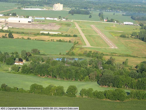
| Abrams Municipal Airport |
| IATA: none – ICAO: none – FAA LID: 4D0 |
| Summary |
| Airport type |
Public |
| Owner |
City of Grand Ledge |
| Serves |
Grand Ledge, Michigan |
| Elevation AMSL |
842 ft / 257 m |
| Coordinates |
42°46′27″N 084°43′59″W / 42.77417°N 84.73306°W / 42.77417; -84.73306 |
| Runways |
| Direction |
Length |
Surface |
| ft |
m |
| 9/27 |
3,200 |
975 |
Asphalt |
| 18/36 |
2,580 |
786 |
Turf |
| Statistics (2007) |
| Aircraft operations |
12,300 |
| Based aircraft |
45 |
| Source: Federal Aviation Administration |
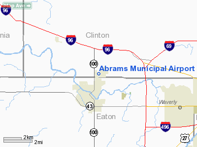
Abrams Municipal Airport (FAA LID: 4D0) is a city-owned, public-use airport located two nautical miles (3.7 km) north of the central business district of Grand Ledge, a city in Clinton County, Michigan, United States. The airport is accessible by road from Eaton Highway, and is located 2.1 miles (3.4 km) south of Interstate 96, just east of M-100.
Facilities and aircraft
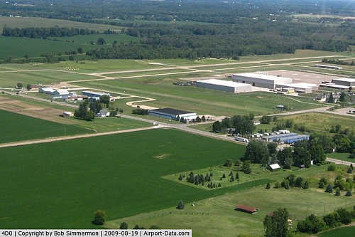
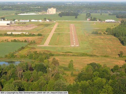
Abrams Municipal Airport covers an area of 160 acres (65 ha) at an elevation of 842 feet (257 m) above mean sea level. It has two runways: 9/27 is 3,200 by 75 feet (975 x 23 m) with an asphalt surface; 18/36 is 2,580 by 120 feet (786 x 37 m) with a turf surface. Runway 18/36 is closed to fixed-wing aircraft from November through April. The airport is staffed daily from 8AM until dusk.
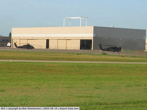
For the 12-month period ending December 31, 2007, the airport had 12,300 aircraft operations, an average of 33 per day: 81% general aviation and 19% military. At that time there were 45 aircraft based at this airport: 49% single-engine, 9% multi-engine and 42% military.
Remarks:
- Activate MIRL runway 09/27 and REIL runway 27 - CTAF.
- Intensive National Guard helicopter training on & in the vicinity of airport.
- Runway 18/36 closed to fixed wing aircraft November-April, soft in spring.
- Avoid overflight of Grand Ledge below 2,000 ft.
- This airport has been surveyed by the National Geodetic Survey.
- TPA for helicopters 1700 ft MSL (858 ft AGL); fixed wing TPA 1900 ft MSL.
The above content comes from Wikipedia and is published under free licenses – click here to read more.
|
 |
(Click on the photo to enlarge) |
|
 |
(Click on the photo to enlarge) |
|
 |
(Click on the photo to enlarge) |
|
 |
(Click on the photo to enlarge) |
Location & QuickFacts
| FAA Information Effective: | 2008-09-25 |
| Airport Identifier: | 4D0 |
| Airport Status: | Operational |
| Longitude/Latitude: | 084-43-59.1530W/42-46-27.1260N
-84.733098/42.774202 (Estimated) |
| Elevation: | 842 ft / 256.64 m (Surveyed) |
| Land: | 160 acres |
| From nearest city: | 2 nautical miles N of Grand Ledge, MI |
| Location: | Clinton County, MI |
| Magnetic Variation: | 05W (1995) |
Owner & Manager
| Ownership: | Publicly owned |
| Owner: | City Of Grand Ledge |
| Address: | 200 E. Jefferson
Grand Ledge, MI 48837 |
| Phone number: | 517-627-2149 |
| Manager: | Jon W. Bayless |
| Address: | City Hall, 200 East Jefferson
Grand Ledge, MI 48837 |
| Phone number: | 517-627-2149 |
Airport Operations and Facilities
| Airport Use: | Open to public |
| Wind indicator: | Yes |
| Segmented Circle: | Yes |
| Control Tower: | No |
| Lighting Schedule: | DUSK-DAWN
ACTVT MIRL RY 09/27 AND REIL RY 27 - CTAF. |
| Beacon Color: | Clear-Green (lighted land airport) |
| Landing fee charge: | No |
| Sectional chart: | Detroit |
| Region: | AGL - Great Lakes |
| Boundary ARTCC: | ZOB - Cleveland |
| Tie-in FSS: | LAN - Lansing |
| FSS on Airport: | No |
| FSS Toll Free: | 1-800-WX-BRIEF |
| NOTAMs Facility: | LAN (NOTAM-d service avaliable) |
| Federal Agreements: | NGY |
Airport Communications
| CTAF: | 122.700 |
| Unicom: | 122.700 |
Airport Services
| Fuel available: | 100LL |
| Airframe Repair: | MAJOR |
| Power Plant Repair: | MAJOR |
| Bottled Oxygen: | NONE |
| Bulk Oxygen: | NONE |
Runway Information
Runway 09/27
| Dimension: | 3200 x 75 ft / 975.4 x 22.9 m |
| Surface: | ASPH, Good Condition |
| Edge Lights: | Medium |
| |
Runway 09 |
Runway 27 |
| Longitude: | 084-44-09.4710W | 084-43-26.7050W |
| Latitude: | 42-46-31.0200N | 42-46-33.4540N |
| Elevation: | 830.00 ft | 840.00 ft |
| Alignment: | 85 | 127 |
| Traffic Pattern: | Left | Left |
| Markings: | Basic, Poor Condition
RWY 09 MARKINGS FADED. | Basic, Poor Condition
RWY 27 MARKINGS FADED. |
| Crossing Height: | 25.00 ft | 25.00 ft |
| VASI: | 4-light PAPI on left side | 2-light PAPI on left side |
| Visual Glide Angle: | 3.00° | 4.00° |
| Runway End Identifier: | | Yes |
| Obstruction: | 70 ft tree, 1950.0 ft from runway, 109 ft left of centerline, 25:1 slope to clear | 22 ft tree, 489.0 ft from runway, 63 ft right of centerline, 13:1 slope to clear
RWY 27 APCH RATIO AT RWY END IS 22:1 BASED ON 53 FT TREES 1,210 FT DST, 77R. |
|
Runway 18/36
| Dimension: | 2580 x 120 ft / 786.4 x 36.6 m |
| Surface: | TURF, Fair Condition |
| |
Runway 18 |
Runway 36 |
| Longitude: | 084-44-12.9530W | 084-44-12.9520W |
| Latitude: | 42-46-38.1250N | 42-46-13.1260N |
| Traffic Pattern: | Left | Left |
| Displaced threshold: | 400.00 ft | 397.00 ft |
| Obstruction: | 85 ft trees, 1305.0 ft from runway, 15:1 slope to clear
RWY 18 APCH RATIO AT DSPLD THLD IS 20:1 | 15 ft road, 45.0 ft from runway, 3:1 slope to clear
RWY 36 APCH RATIO AT DSPLD THLD IS 29:1 |
|
Radio Navigation Aids
| ID |
Type |
Name |
Ch |
Freq |
Var |
Dist |
| BT | NDB | Batol | | 272.00 | 04W | 31.8 nm |
| AMN | NDB | Alma | | 329.00 | 05W | 33.1 nm |
| OZW | NDB | Howell | | 243.00 | 05W | 34.0 nm |
| JXN | VOR/DME | Jackson | 033X | 109.60 | 05W | 33.3 nm |
| GRR | VOR/DME | Grand Rapids | 106Y | 115.95 | 04W | 33.7 nm |
| LFD | VOR/DME | Litchfield | 049X | 111.20 | 05W | 42.8 nm |
| AZO | VOR/DME | Kalamazoo | 027X | 109.00 | 01W | 48.6 nm |
| LAN | VORTAC | Lansing | 045X | 110.80 | 05W | 3.8 nm |
| BTL | VORTAC | Battle Creek | 031X | 109.40 | 02W | 36.2 nm |
| FNT | VORTAC | Flint | 116X | 116.90 | 06W | 45.0 nm |
Remarks
- INTENSIVE NG HELICOPTER TRNG ON & INVOF ARPT.
- EXIT RY 18/36 ONLY AT TWYS.
- RY 18/36 CLSD TO FIXED WING ACFT NOV-APR, SOFT IN SPRING.
- AVOID OVFT OF GRAND LEDGE BLO 2,000 FT.
Images and information placed above are from
http://www.airport-data.com/airport/4D0/
We thank them for the data!
| General Info
|
| Country |
United States
|
| State |
MICHIGAN
|
| FAA ID |
4D0
|
| Latitude |
42-46-27.126N
|
| Longitude |
084-43-59.153W
|
| Elevation |
842 feet
|
| Near City |
GRAND LEDGE
|
We don't guarantee the information is fresh and accurate. The data may
be wrong or outdated.
For more up-to-date information please refer to other sources.
|
|


