 |
|
| Tipton Airport |
| IATA: FME – ICAO: KFME – FAA LID: FME |
| Summary |
| Airport type |
Public |
| Owner |
Tipton Airport Authority |
| Location |
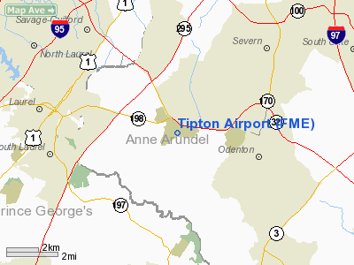
Fort Meade / Odenton, Maryland |
| Elevation AMSL |
150 ft / 46 m |
| Coordinates |
39°05′07″N 076°45′34″W / 39.08528°N 76.75944°W / 39.08528; -76.75944 |
| Website |
TiptonAirport.org |
| Runways |
| Direction |
Length |
Surface |
| ft |
m |
| 10/28 |
3,000 |
914 |
Asphalt |
| Statistics (2006) |
| Aircraft operations |
48,000 |
| Based aircraft |
111 |
| Source: Federal Aviation Administration |
Tipton Airport (IATA: FME, ICAO: KFME, FAA LID: FME) is a public airport located just south of Fort George G. Meade in Odenton, Anne Arundel County, Maryland. The facility is bordered by Fort Meade, the National Security Agency, and the Patuxent Wildlife Research Center. This airport opened in 1999 on the site of a former United States Army Airfield that was closed in 1995. It is operated by the Tipton Airport Authority.
Facilities and aircraft
Tipton Airport covers an area of 366 acres (148 ha) which contains one paved runway (10/28) measuring 3,000 x 75 ft (914 x 23 m).
For 12-month period ending April 02, 2008, the airport had 49,225 aircraft operations, an average of 134 per day: 98% general aviation and 2% air taxi. There are 128 aircraft/rotorcraft based at this airport: 85% single engine, 9% multi-engine and 6% helicopters.
The above content comes from Wikipedia and is published under free licenses – click here to read more.
|
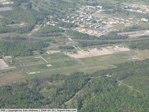 |
(Click on the photo to enlarge) |
Location & QuickFacts
| FAA Information Effective: | 2008-09-25 |
| Airport Identifier: | FME |
| Airport Status: | Operational |
| Longitude/Latitude: | 076-45-33.8920W/39-05-07.3920N
-76.759414/39.085387 (Estimated) |
| Elevation: | 150 ft / 45.72 m (Estimated) |
| Land: | 366 acres |
| From nearest city: | 1 nautical miles SW of Fort Meade(odenton), MD |
| Location: | Anne Arundel County, MD |
| Magnetic Variation: | 10W (1985) |
Owner & Manager
| Ownership: | Publicly owned |
| Owner: | Tipton Arpt Authority |
| Address: | Po Box 155
Odenton, MD 21113 |
| Phone number: | 410-222-6815 |
| Manager: | Michael A Wassel |
| Address: | Po Box 155
Odenton, MD 21113-0155 |
| Phone number: | 410-222-6815 |
Airport Operations and Facilities
| Airport Use: | Open to public |
| Wind indicator: | Yes |
| Segmented Circle: | Yes |
| Control Tower: | No |
| Lighting Schedule: | DUSK-DAWN
ACTVT MIRL RY 10/28 - CTAF. |
| Beacon Color: | Clear-Green (lighted land airport) |
| Landing fee charge: | No |
| Sectional chart: | Washington |
| Region: | AEA - Eastern |
| Traffic Pattern Alt: | 850 ft |
| Boundary ARTCC: | ZDC - Washington |
| Tie-in FSS: | DCA - Leesburg |
| FSS on Airport: | No |
| FSS Toll Free: | 1-800-WX-BRIEF |
| NOTAMs Facility: | FME (NOTAM-d service avaliable) |
| Federal Agreements: | N |
Airport Communications
| CTAF: | 123.050 |
| Unicom: | 123.050 |
Airport Services
| Fuel available: | 100LLA |
| Airframe Repair: | NONE |
| Power Plant Repair: | MINOR |
Runway Information
Runway 10/28
| Dimension: | 3000 x 75 ft / 914.4 x 22.9 m |
| Surface: | ASPH, |
| Edge Lights: | Medium |
| |
Runway 10 |
Runway 28 |
| Longitude: | 076-45-53.3500W | 076-45-15.3900W |
| Latitude: | 39-05-07.9200N | 39-05-05.8900N |
| Elevation: | 115.00 ft | 150.00 ft |
| Alignment: | 94 | 127 |
| Traffic Pattern: | Right | Left |
| Markings: | Non-precision instrument, Good Condition | Non-precision instrument, Good Condition |
| Crossing Height: | 51.00 ft | 57.00 ft |
| VASI: | 2-light PAPI on left side
PAPI RY 10 UNUSBL 8 DEGS LEFT & RIGHT OF COURSE. | 2-light PAPI on left side
RY 28 PAPI UNUSBL 5 DEGS LEFT OF COURSE (TREES) AND 8 DEGS RIGHT OF COURSE. |
| Visual Glide Angle: | 4.00° | 4.00° |
| Runway End Identifier: | Yes | Yes |
| Obstruction: | 49 ft trees, 1217.0 ft from runway, 20:1 slope to clear | 20 ft trees, 200.0 ft from runway, 180 ft left of centerline
RY 28 +20 FT TREES 180 FT FM THLD 180 FT LEFT. |
|
Radio Navigation Aids
| ID |
Type |
Name |
Ch |
Freq |
Var |
Dist |
| FND | NDB | Ellicott | | 371.00 | 11W | 12.2 nm |
| IUB | NDB | Institute | | 404.00 | 08W | 13.6 nm |
| GTN | NDB | Georgetown | | 323.00 | 09W | 19.4 nm |
| GAI | NDB | Gaithersburg | | 385.00 | 09W | 19.6 nm |
| MTN | NDB | Martin | | 342.00 | 11W | 21.9 nm |
| VKX | NDB | Potomac | | 241.00 | 10W | 22.2 nm |
| DC | NDB | Oxonn | | 332.00 | 11W | 22.9 nm |
| ESN | NDB | Easton | | 212.00 | 10W | 36.4 nm |
| APG | NDB | Aberdeen | | 349.00 | 11W | 40.7 nm |
| CGE | NDB | Cambridge | | 355.00 | 10W | 47.4 nm |
| MTN | TACAN | Martin | 068X | | 11W | 21.9 nm |
| FDK | VOR | Frederick | | 109.00 | 08W | 34.7 nm |
| DCA | VOR/DME | Washington | 047X | 111.00 | 09W | 18.8 nm |
| PPM | VOR/DME | Phillips | 021X | 108.40 | 09W | 35.7 nm |
| BAL | VORTAC | Baltimore | 098X | 115.10 | 11W | 6.9 nm |
| ADW | VORTAC | Andrews | 078X | 113.10 | 10W | 17.5 nm |
| OTT | VORTAC | Nottingham | 084X | 113.70 | 10W | 22.8 nm |
| EMI | VORTAC | Westminster | 126X | 117.90 | 08W | 26.6 nm |
| AML | VORTAC | Armel | 082X | 113.50 | 08W | 34.3 nm |
| ADW | VOT | Andrews Afb | | 109.60 | | 18.7 nm |
| DCA | VOT | Washington National | | 109.40 | | 19.3 nm |
Remarks
- DEER ON RWY & TWY.
- BE ALERT FOR NUMEROUS BWI TURBOJET ARRIVALS/DEPARTURES IN THE AREA. FLY TFC PATTERN SOUTH OF THE FIELD TO AVIOD BWI CLASS B AIRSPACE. REMAIN CLEAR OF BWI CLASS B AIRSPACE UNTIL CLEARANCE IS OBTAINED.
Images and information placed above are from
http://www.airport-data.com/airport/FME/
We thank them for the data!
| General Info
|
| Country |
United States
|
| State |
MARYLAND
|
| FAA ID |
FME
|
| Latitude |
39-05-07.392N
|
| Longitude |
076-45-33.892W
|
| Elevation |
150 feet
|
| Near City |
FORT MEADE(ODENTON)
|
We don't guarantee the information is fresh and accurate. The data may
be wrong or outdated.
For more up-to-date information please refer to other sources.
|
|


