 |
|
St. Mary's County Regional Airport |
Coordinates: 38°18′55″N 076°33′00″W / 38.31528°N 76.55°W / 38.31528; -76.55
St. Mary's County Regional Airport
Capt. Walter Francis Duke Regional Airport |
 |
| IATA: LTW – ICAO: none – FAA LID: 2W6 |
| Summary |
| Airport type |
Public |
| Owner/Operator |
St. Mary's County |
| Location |
Leonardtown, Maryland |
| Elevation AMSL |
142 ft / 43 m |
| Runways |
| Direction |
Length |
Surface |
| ft |
m |
| 11/29 |
4,150 |
1,265 |
Asphalt |
| Statistics (2006) |
| Aircraft operations |
52,618 |
| Based aircraft |
100 |
| Source: Federal Aviation Administration |
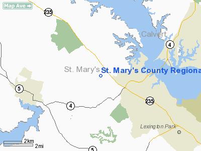
St. Mary's County Regional Airport (IATA: LTW, FAA LID: 2W6), also known as Captain Walter Francis Duke Regional Airport, is a public airport located in St. Mary's County, Maryland, four miles (six km) northeast of the central business district of Leonardtown. The airport is also located eight nautical miles east of Naval Air Station Patuxent River. It is owned and operated by the St. Mary's County Board of County Commissioners.
St. Mary's County Regional Airport has been in operation since 1969. The airport was re-dedicated as the Captain Walter Francis Duke Regional Airport in 2000. It recently reverted back to its original name.
Facilities and aircraft
St. Mary's County Regional Airport covers an area of 200 acres (81 ha) which contains one asphalt paved runway (11/29) measuring 4,150 x 75 ft (1,265 x 23 m).
For the 12-month period ending April 6, 2006, the airport had 52,618 aircraft operations, an average of 144 per day: 95% general aviation, 5% air taxi and <1% military. There are 100 aircraft based at this airport: 86% single engine, 8% multi-engine, 3% helicopters, 2% ultralight and 1% gliders.
The airport houses small aircraft such as Pipers, gliders, and Cessnas (152's, 172's, etc.). The Maryland State Police house one of their helicopters, Trooper 7, at the airport. Trooper 7 flies medevacs all over the area including to as far north as Montgomery county and even in to northern Virginia. There is also a small flying club where people can learn to fly and rent planes to fly over the Chesapeake Bay.
The St. Mary's County Chamber of Commerce has its offices in the terminal building of the airport. Groups like the EAA and Civil Air Patrol also meet there.
The above content comes from Wikipedia and is published under free licenses – click here to read more.
Location & QuickFacts
| FAA Information Effective: | 2008-09-25 |
| Airport Identifier: | 2W6 |
| Airport Status: | Operational |
| Longitude/Latitude: | 076-33-00.4000W/38-18-55.3000N
-76.550111/38.315361 (Estimated) |
| Elevation: | 142 ft / 43.28 m (Surveyed) |
| Land: | 200 acres |
| From nearest city: | 4 nautical miles NE of Leonardtown, MD |
| Location: | St Marys County, MD |
| Magnetic Variation: | 10W (1995) |
Owner & Manager
| Ownership: | Publicly owned |
| Owner: | St Marys Co Comsnrs |
| Address: | 23115 Leonard Hall Dr.
Leonardtown, MD 20650 |
| Phone number: | 301-475-4460 |
| Manager: | George A. Erichsen |
| Address: | 44200 Airport Rd.
California, MD 20619 |
| Phone number: | 301-863-8400 |
Airport Operations and Facilities
| Airport Use: | Open to public |
| Wind indicator: | Yes |
| Segmented Circle: | Yes |
| Control Tower: | No |
| Lighting Schedule: | DUSK-DAWN
ACTVT MIRL RY 11/29; REIL RYS 11 & 29 - CTAF. |
| Beacon Color: | Clear-Green (lighted land airport) |
| Landing fee charge: | No |
| Sectional chart: | Washington |
| Region: | AEA - Eastern |
| Boundary ARTCC: | ZDC - Washington |
| Tie-in FSS: | DCA - Leesburg |
| FSS on Airport: | No |
| FSS Toll Free: | 1-800-WX-BRIEF |
| NOTAMs Facility: | DCA (NOTAM-d service avaliable) |
| Federal Agreements: | NGY |
Airport Communications
| CTAF: | 123.000 |
| Unicom: | 123.000 |
Airport Services
| Fuel available: | 100LLA |
| Airframe Repair: | MAJOR |
| Power Plant Repair: | MAJOR |
| Bottled Oxygen: | NONE |
| Bulk Oxygen: | NONE |
Runway Information
Runway 11/29
| Dimension: | 4150 x 75 ft / 1264.9 x 22.9 m |
| Surface: | ASPH, Good Condition |
| Weight Limit: | Single wheel: 12500 lbs. |
| Edge Lights: | Medium |
| |
Runway 11 |
Runway 29 |
| Longitude: | 076-33-25.8506W | 076-32-34.9851W |
| Latitude: | 38-18-59.6584N | 38-18-50.9088N |
| Elevation: | 142.00 ft | 125.00 ft |
| Alignment: | 102 | 127 |
| Traffic Pattern: | Left | Left |
| Markings: | Non-precision instrument, Good Condition | Non-precision instrument, Good Condition |
| VASI: | 2-light PAPI on left side | 2-light PAPI on left side |
| Runway End Identifier: | Yes | Yes |
| Obstruction: | 32 ft trees, 650.0 ft from runway, 243 ft left of centerline, 14:1 slope to clear | , 20:1 slope to clear |
|
Radio Navigation Aids
| ID |
Type |
Name |
Ch |
Freq |
Var |
Dist |
| NHK | NDB | Patuxent | | 400.00 | 10W | 7.2 nm |
| CGE | NDB | Cambridge | | 355.00 | 10W | 27.8 nm |
| VKX | NDB | Potomac | | 241.00 | 10W | 32.3 nm |
| DC | NDB | Oxonn | | 332.00 | 11W | 35.2 nm |
| ESN | NDB | Easton | | 212.00 | 10W | 37.1 nm |
| APH | NDB | A P Hill | | 396.00 | 10W | 39.1 nm |
| EZF | NDB | Shannon | | 237.00 | 10W | 42.6 nm |
| GTN | NDB | Georgetown | | 323.00 | 09W | 45.7 nm |
| BUH | NDB | Anne Arundel | | 260.00 | 10W | 47.2 nm |
| DCA | VOR/DME | Washington | 047X | 111.00 | 09W | 39.9 nm |
| PXT | VORTAC | Patuxent | 123X | 117.60 | 10W | 7.3 nm |
| OTT | VORTAC | Nottingham | 084X | 113.70 | 10W | 25.2 nm |
| ADW | VORTAC | Andrews | 078X | 113.10 | 10W | 33.1 nm |
| BRV | VORTAC | Brooke | 092X | 114.50 | 09W | 37.9 nm |
| SBY | VORTAC | Salisbury | 049X | 111.20 | 12W | 49.0 nm |
| ADW | VOT | Andrews Afb | | 109.60 | | 32.4 nm |
| DCA | VOT | Washington National | | 109.40 | | 39.1 nm |
Remarks
- DEER ON & INVOF RY 11/29 SS-SR.
- GLIDER & ULTRALIGHT ACTIVITY ON & INVOF ARPT.
- RY 29 15 FT DEPRESSION (DOWNSLOPE) 300 FT FM THLD 150 FT R-125 L.
Images and information placed above are from
http://www.airport-data.com/airport/2W6/
We thank them for the data!
| General Info
|
| Country |
United States
|
| State |
MARYLAND
|
| FAA ID |
2W6
|
| Time |
UTC-5(-4DT)
|
| Latitude |
38.315361
38° 18' 55.30" N
|
| Longitude |
-76.550111
076° 33' 00.40" W
|
| Elevation |
142 feet
43 meters
|
| Type |
Civil
|
| Magnetic Variation |
011° W (01/06)
|
| Beacon |
Yes
|
| Operating Agency |
U.S.CIVIL AIRPORT WHEREIN PERMIT COVERS USE BY TRANSIT MILITARY AIRCRAFT
|
| Near City |
Leonardtown
|
| Operating Hours |
SEE REMARKS FOR OPERATING HOURS OR COMMUNICATIONS FOR POSSIBLE HOURS
|
| Daylight Saving Time |
Second Sunday in March at 0200 to first Sunday in November at 0200 local time (Exception Arizona and that portion of Indiana in the Eastern Time Zone)
|
We don't guarantee the information is fresh and accurate. The data may
be wrong or outdated.
For more up-to-date information please refer to other sources.
|
|


