 |
|
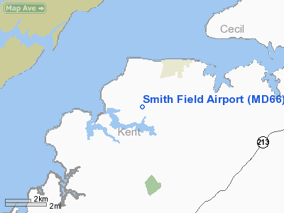
Location & QuickFacts
| FAA Information Effective: | 2008-09-25 |
| Airport Identifier: | MD66 |
| Airport Status: | Operational |
| Longitude/Latitude: | 076-05-52.8150W/39-20-16.3980N
-76.098004/39.337888 (Estimated) |
| Elevation: | 60 ft / 18.29 m (Estimated) |
| Land: | 0 acres |
| From nearest city: | 8 nautical miles N of Chestertown, MD |
| Location: | Kent County, MD |
| Magnetic Variation: | 10W (1985) |
Owner & Manager
| Ownership: | Privately owned |
| Owner: | Raymond B. Smith |
| Address: | 98 Bissell Rd
Lebanon, NJ 08833 |
| Phone number: | 908-236-2472 |
| Manager: | Raymond B. Smith |
| Address: | 98 Bissell Rd
Lebanon, NJ 08833 |
| Phone number: | 908-236-2472 |
Airport Operations and Facilities
| Airport Use: | Private |
| Wind indicator: | Yes |
| Segmented Circle: | No |
| Control Tower: | No |
| Sectional chart: | Washington |
| Region: | AEA - Eastern |
| Boundary ARTCC: | ZDC - Washington |
| Tie-in FSS: | DCA - Leesburg |
| FSS on Airport: | No |
| FSS Toll Free: | 1-800-WX-BRIEF |
Runway Information
Runway 03/21
| Dimension: | 3000 x 60 ft / 914.4 x 18.3 m |
| Surface: | TURF, |
| |
Runway 03 |
Runway 21 |
| Traffic Pattern: | Left | Left |
| Obstruction: | 25 ft pline, 385.0 ft from runway | , 100.0 ft from runway |
|
Radio Navigation Aids
| ID |
Type |
Name |
Ch |
Freq |
Var |
Dist |
| APG | NDB | Aberdeen | | 349.00 | 11W | 11.9 nm |
| MTN | NDB | Martin | | 342.00 | 11W | 13.3 nm |
| IUB | NDB | Institute | | 404.00 | 08W | 24.7 nm |
| FND | NDB | Ellicott | | 371.00 | 11W | 31.7 nm |
| ESN | NDB | Easton | | 212.00 | 10W | 32.1 nm |
| BUH | NDB | Anne Arundel | | 260.00 | 10W | 34.4 nm |
| RNB | NDB | Rainbow | | 363.00 | 11W | 45.0 nm |
| CGE | NDB | Cambridge | | 355.00 | 10W | 48.2 nm |
| MTN | TACAN | Martin | 068X | | 11W | 14.6 nm |
| DOV | TACAN | Dover | 037X | | 09W | 31.9 nm |
| PPM | VOR/DME | Phillips | 021X | 108.40 | 09W | 8.5 nm |
| ENO | VORTAC | Smyrna | 051X | 111.40 | 09W | 27.8 nm |
| BAL | VORTAC | Baltimore | 098X | 115.10 | 11W | 28.1 nm |
| DQO | VORTAC | Dupont | 087X | 114.00 | 10W | 30.6 nm |
| MXE | VORTAC | Modena | 079X | 113.20 | 09W | 40.1 nm |
| OOD | VORTAC | Woodstown | 075X | 112.80 | 10W | 41.0 nm |
| EMI | VORTAC | Westminster | 126X | 117.90 | 08W | 42.0 nm |
| LRP | VORTAC | Lancaster | 120X | 117.30 | 09W | 47.9 nm |
| ADW | VORTAC | Andrews | 078X | 113.10 | 10W | 48.0 nm |
| OTT | VORTAC | Nottingham | 084X | 113.70 | 10W | 48.5 nm |
| ADW | VOT | Andrews Afb | | 109.60 | | 49.2 nm |
Remarks
- USED IN VFR DALGT OPNS ONLY; THR OF RY 21 DSPLCD 15 FT TO ENSURE 20:1 CLNC PLANE OVER THE PLINE 25 FT HIGH & 385 FT NORTH OF THE RY; COORDINATE WITH THE OPERATOR OF HARRIS ARPT TO BECOME AWARE OF TFC PATTERN EXTREMITIES & VISUAL CHECK POINTS.
Images and information placed above are from
http://www.airport-data.com/airport/MD66/
We thank them for the data!
| General Info
|
| Country |
United States
|
| State |
MARYLAND
|
| FAA ID |
MD66
|
| Latitude |
39-20-16.398N
|
| Longitude |
076-05-52.815W
|
| Elevation |
60 feet
|
| Near City |
CHESTERTOWN
|
We don't guarantee the information is fresh and accurate. The data may
be wrong or outdated.
For more up-to-date information please refer to other sources.
|
|


