|
 |
|
||||
|
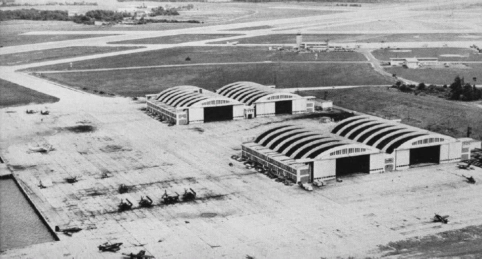
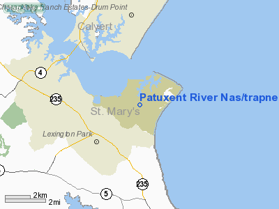
"Pax River" redirects here. For the river, see Patuxent River. Naval Air Station Patuxent River (IATA: NHK, ICAO: KNHK, FAA LID: NHK), also known as NAS Pax River, is a United States Naval Air Station located in St. Mary's County, Maryland on the Chesapeake Bay near the mouth of the Patuxent River. It is home to the U.S. Naval Test Pilot School, and serves as a center for test and evaluation and systems acquisition relating to Naval Aviation. Commissioned on April 1, 1943 on land largely acquired through eminent domain, the air station grew rapidly in response to World War II. The base became a center for testing as several facilities were constructed throughout the 1950s and 1960s; including the U.S. Naval Test Pilot School (1958), the Weapons Systems Test Division (1960), and the Propulsion System Evaluation Facility. The base also served as the testing facility for the V-22 Osprey. Since the end of the Cold War, the Navy's Base Realignment and Closure measures have migrated research and testing facilities for both rotary and fixed-wing aircraft to NAS Patuxent River from decommissioned bases. The complex now hosts over 17,000 people, including active-duty service members, civil-service employees, defense contractor employees, and military dependents. NAS Patuxent River is home to the Naval Air Systems Command (NAVAIR) Headquarters, the Air Test Wing Atlantic, and the Naval Air Warfare Center Aircraft Division (NAWCAD) Commands. It was used as a filming location for the Harrison Ford movie Random Hearts (1999). Ford and director Sydney Pollack both visited Naval Air Station Patuxent River. Ford, a certificated pilot, flew the aircraft himself. HistoryGenesis
Situated on a peninsula between the Patuxent River and the Chesapeake Bay, NAS Patuxent River is located on 6,400 acres (26 km) of what was once prime farmland, consisting of several large plantations, Mattapony, Susquehanna, and Cedar Point, as well as numerous tenant and sharecropper properties and a few clusters of vacation homes. The Cedar Point community included several churches, a post office, and a gas station. Some of the old homes now serve as quarters for Navy personnel stationed there. In 1937, the Navy's Bureau of Aeronautics sought to consolidate aviation test programs, previously being conducted at several stations, including Dahlgren and Norfolk, the Washington Navy Yard, Naval Air Station Anacostia in Washington, D.C., and the Naval Aircraft Factory in Philadelphia, Pennsylvania. Cedar Point was selected due to its remote location on the coastline, well removed from air traffic congestion, with ample space for weapons testing. Wartime urgency
The onset of American involvement in World War II spurred establishment of the new air station. Rear Admiral John Henry Towers, Chief of Bureau of Aeronautics, requested approval and authorization to begin construction on December 22, 1941. Secretary of the Navy, Frank Knox, gave approval on January 7, 1942 and construction began on April 4, 1942. Residents had about a month, until March 1, 1942, to relocate as the federal government purchased all the land at a cost of $712,287 for 6,412 acres (26 km). A lack of transportation in Saint Mary's County led the Navy to revitalize a Pennsylvania Railroad branchline from Brandywine to Mechanicsville, Maryland and build an extension south from Mechanicsville to the air station in 1944. Known as the U.S. Government Railroad, the rail line was steam-powered and operated south of Brandywine for exclusive official use until 1954, when it ceased operation. A highway extension to the new air station was required by the project—250,000 tons of material were transported by either truck or water routes during a year of construction. Employing some 7,000 at its peak of construction, the area had very Gold Rush "boom town" feel as local residents were joined by workers from all over the country, eager to get on the high-paying jobs on station. The Marines take chargeOn 20 October 1942, U.S. Marines first arrived and took over security. Today, the station utilizes Navy Masters-At-Arms (MA) and Department of Defense Police for standard local law enforcement, the Naval Criminal Investigative Service (NCIS) for high profile criminal investigations, and a contract security force for access control. During construction, housing needs far outstripped supply, and barracks were built for workers on the station. Later, several housing areas were erected off station for workers and their families in Lexington Park, formerly Jarboesville, named in honor of the USS Lexington, the Navy's second aircraft carrier, lost during the Battle of the Coral Sea on 8 May 1942. DedicationThe station was formally commissioned "U.S. Naval Air Station, Patuxent River, Maryland" on 1 April 1943. In a ceremony presided over by RADM John S. McCain, Sr., then chief of the Bureau of Aeronautics, Patuxent river was referred to as "the most needed station in the Navy." The unofficial name had been Cedar Point or the Naval Air Station at Cedar Point, but officials were concerned about possible confusion with the Marine Corps Air Station Cherry Point, North Carolina, so the new facility was named for the adjacent river. Trapnell FieldOn 1 April 1976, Patuxent River's air field was named after pioneering aviator VADM Frederick M. Trapnell, a former commander of the Naval Air Test Center at the station. Keynote address speaker, ADM Frederick H. Michaelis, Chief of Naval Material, noted: "All who fly in Navy blue remain indebted to Vice Admiral Trapnell. This field will serve as a living reminder of that debt." Tenant Commands
Patuxent River Naval Air MuseumPatuxent River Naval Air Museum
The above content comes from Wikipedia and is published under free licenses – click here to read more.
Location & QuickFacts
Owner & Manager
Airport Operations and Facilities
Runway InformationRunway 02/20
Runway 06/24
Runway 14/32
Radio Navigation Aids
Remarks
Images and information placed above are from We thank them for the data!
We don't guarantee the information is fresh and accurate. The data may
be wrong or outdated.
|
|||||||||||||||||||||||||||||||||||||||||||||||||||||||||||||||||||||||||||||||||||||||||||||||||||||||||||||||||||||||||||||||||||||||||||||||||||||||||||||||||||||||||||||||||||||||||||||||||||||||||||||||||||||||||||||||||||||||||||||||||||||||||||||||||||||||||||||||||||||||||||||||||||||||||||||||||||||||||||||||||||||||||||||||||||||||||||||||||||||||||||||||||||||||||||||||||||||||||||||||||||||||||||

 |
|
Copyright 2004-2024 © by Airports-Worldwide.com, Vyshenskoho st. 36, Lviv 79010, Ukraine Legal Disclaimer |