 |
|
Coordinates: 38°56′29″N 076°46′21″W / 38.94139°N 76.7725°W / 38.94139; -76.7725
| Freeway Airport |
| IATA: none – ICAO: none – FAA LID: W00 |
| Summary |
| Airport type |
Public |
| Owner |
Rodenhauser Family Trust |
| Serves |
Mitchellville, Maryland |
| Elevation AMSL |
168 ft / 51 m |
| Runways |
| Direction |
Length |
Surface |
| ft |
m |
| 18/36 |
2,420 |
738 |
Asphalt |
| Statistics (2007) |
| Aircraft operations |
61,456 |
| Source: Federal Aviation Administration |
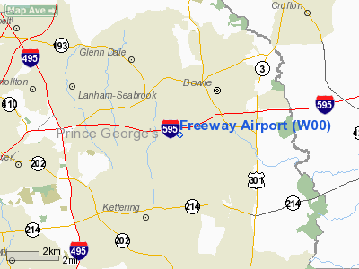
Freeway Airport (FAA LID: W00) is a privately-owned, public-use airport located two miles (3 km) northwest of the central business district of Mitchellville, in Prince Georges County, Maryland, United States. History
Hani Hanjour, one of the hijackers involved in the events of September 11, 2001 trained at Freeway Airport. A month before the attack, "instructors at Freeway Airport in Bowie flew with him and deemed him unfit to rent a plane by himself."
Facilities and aircraft
Freeway Airport covers an area of 100 acres (40 ha) which contains one runway designated 18/36 with a 2,420 x 40 ft (738 x 12 m) asphalt surface. For the 12-month period ending September 24, 2007, the airport had 61,456 aircraft operations, an average of 168 per day: 96% general aviation, 3% military and 1% air taxi.
The above content comes from Wikipedia and is published under free licenses – click here to read more.
Location & QuickFacts
| FAA Information Effective: | 2008-09-25 |
| Airport Identifier: | W00 |
| Airport Status: | Operational |
| Longitude/Latitude: | 076-46-20.5790W/38-56-28.8670N
-76.772383/38.941352 (Estimated) |
| Elevation: | 168 ft / 51.21 m (Surveyed) |
| Land: | 100 acres |
| From nearest city: | 2 nautical miles NW of Mitchellville, MD |
| Location: | Prince Georges County, MD |
| Magnetic Variation: | 10W (1995) |
Owner & Manager
| Ownership: | Privately owned |
| Owner: | Rodenhauser Family Trust |
| Address: | 3900 Church Rd
Mitchellville, MD 20716 |
| Phone number: | 301-390-6424 |
| Manager: | Stanley Rodenhauser |
| Address: | 3900 Church Rd
Mitchellville, MD 20716 |
| Phone number: | 301-390-6424 |
Airport Operations and Facilities
| Airport Use: | Open to public |
| Wind indicator: | Yes |
| Segmented Circle: | Yes |
| Control Tower: | No |
| Lighting Schedule: | DUSK-DAWN
ACTVT MIRL RY 18/36 & PAPI RYS 18 & 36 - CTAF. |
| Beacon Color: | Clear-Green (lighted land airport) |
| Sectional chart: | Washington |
| Region: | AEA - Eastern |
| Boundary ARTCC: | ZDC - Washington |
| Tie-in FSS: | DCA - Leesburg |
| FSS on Airport: | No |
| FSS Toll Free: | 1-800-WX-BRIEF |
| NOTAMs Facility: | DCA (NOTAM-d service avaliable) |
Airport Communications
| CTAF: | 123.075 |
| Unicom: | 123.075 |
Airport Services
| Fuel available: | 100LL |
| Airframe Repair: | MAJOR |
| Power Plant Repair: | MAJOR |
| Bottled Oxygen: | NONE |
| Bulk Oxygen: | NONE |
Runway Information
Runway 18/36
| Dimension: | 2420 x 40 ft / 737.6 x 12.2 m |
| Surface: | ASPH, Good Condition |
| Edge Lights: | Medium |
| |
Runway 18 |
Runway 36 |
| Longitude: | 076-46-23.1700W | 076-46-17.9800W |
| Latitude: | 38-56-40.7200N | 38-56-17.1500N |
| Elevation: | 168.00 ft | 152.00 ft |
| Alignment: | 127 | 127 |
| Traffic Pattern: | Left | Right |
| Markings: | Non-precision instrument, Good Condition | Non-precision instrument, Good Condition |
| Crossing Height: | 47.00 ft | 26.00 ft |
| Displaced threshold: | 0.00 ft | 230.00 ft |
| VASI: | 2-light PAPI on right side | 2-light PAPI on left side |
| Visual Glide Angle: | 6.00° | 5.50° |
| Obstruction: | 54 ft trees, 765.0 ft from runway, 10:1 slope to clear
+7 FT ROAD AT 115 FT OUT, OB. | 52 ft trees, 375.0 ft from runway, 240 ft right of centerline, 3:1 slope to clear
11:1 CLNC TO DSPLCD THLD. |
|
Radio Navigation Aids
| ID |
Type |
Name |
Ch |
Freq |
Var |
Dist |
| BUH | NDB | Anne Arundel | | 260.00 | 10W | 8.6 nm |
| VKX | NDB | Potomac | | 241.00 | 10W | 14.4 nm |
| DC | NDB | Oxonn | | 332.00 | 11W | 15.9 nm |
| GTN | NDB | Georgetown | | 323.00 | 09W | 16.5 nm |
| FND | NDB | Ellicott | | 371.00 | 11W | 20.8 nm |
| IUB | NDB | Institute | | 404.00 | 08W | 21.9 nm |
| GAI | NDB | Gaithersburg | | 385.00 | 09W | 22.9 nm |
| MTN | NDB | Martin | | 342.00 | 11W | 28.3 nm |
| ESN | NDB | Easton | | 212.00 | 10W | 33.9 nm |
| CGE | NDB | Cambridge | | 355.00 | 10W | 42.3 nm |
| NHK | NDB | Patuxent | | 400.00 | 10W | 43.0 nm |
| APG | NDB | Aberdeen | | 349.00 | 11W | 47.3 nm |
| GDX | NDB | Goodwin Lake | | 227.00 | 08W | 49.5 nm |
| MTN | TACAN | Martin | 068X | | 11W | 28.8 nm |
| FDK | VOR | Frederick | | 109.00 | 08W | 39.9 nm |
| DCA | VOR/DME | Washington | 047X | 111.00 | 09W | 13.3 nm |
| PPM | VOR/DME | Phillips | 021X | 108.40 | 09W | 42.2 nm |
| ADW | VORTAC | Andrews | 078X | 113.10 | 10W | 9.2 nm |
| OTT | VORTAC | Nottingham | 084X | 113.70 | 10W | 14.2 nm |
| BAL | VORTAC | Baltimore | 098X | 115.10 | 11W | 14.7 nm |
| AML | VORTAC | Armel | 082X | 113.50 | 08W | 32.5 nm |
| EMI | VORTAC | Westminster | 126X | 117.90 | 08W | 34.6 nm |
| PXT | VORTAC | Patuxent | 123X | 117.60 | 10W | 43.0 nm |
| BRV | VORTAC | Brooke | 092X | 114.50 | 09W | 45.4 nm |
| ADW | VOT | Andrews Afb | | 109.60 | | 10.5 nm |
| DCA | VOT | Washington National | | 109.40 | | 13.5 nm |
Remarks
- TPA 1000 FT MSL (832 FT AGL) FOR ACFT LESS THAN 4000 LBS MAX GWT; TPA 1200 FT MSL (1032 FT AGL) FOR ACFT GREATER THAN 4000 LBS.
- -15 FT DROP 80 FT FROM APCH TO RY 36.
- -7 FT DROP 50 FT FM APCH END RY 18.
- LGTD ANTENNA 135 FT AGL 600 FT NW AER 18.
- STANDARD INSTRUMENT APPROACH PROCEDURES FOR FREEWAY ARPT ARE AUTHORIZED TO PENETRATE THE WASHINGTON D.C. FLIGHT RESTRICTED ZONE UNDER THE FOLLOWING PROVISIONS: ONLY FAR PARTS 91 & 135 OPERATORS AUTHORIZED. NO PRACTICE APPROACHES.
- ESTAB PRIOR TO 1959.
Images and information placed above are from
http://www.airport-data.com/airport/W00/
We thank them for the data!
| General Info
|
| Country |
United States
|
| State |
MARYLAND
|
| FAA ID |
W00
|
| Latitude |
38-56-28.920N
|
| Longitude |
076-46-20.590W
|
| Elevation |
168 feet
|
| Near City |
MITCHELLVILLE
|
We don't guarantee the information is fresh and accurate. The data may
be wrong or outdated.
For more up-to-date information please refer to other sources.
|
|


