 |
|
| College Park Airport |
| IATA: CGS – ICAO: KCGS |
| Summary |
| Airport type |
Public |
| Operator |
Maryland-National Capital Park & Planning Commission |
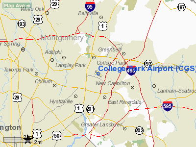
| Location |
College Park, Maryland |
| Elevation AMSL |
48 ft / 14.6 m |
| Coordinates |
38°58′50.1″N 76°55′20.3″W / 38.980583°N 76.922306°W / 38.980583; -76.922306Coordinates: 38°58′50.1″N 76°55′20.3″W / 38.980583°N 76.922306°W / 38.980583; -76.922306 |
| Runways |
| Direction |
Length |
Surface |
| ft |
m |
| 15/33 |
2,607 |
795 |
Asphalt |
| College Park Airport |
| U.S. National Register of Historic Places |
|
College Park Aviation Museum, December 2008
|
| Nearest city: |
College Park, Maryland |
| Built/Founded: |
1908 |
| Architect: |
Unknown |
| Architectural style(s): |
No Style Listed |
| Governing body: |
Local |
| Added to NRHP: |
September 23, 1977 |
| NRHP Reference#: |
77001522
|
College Park Airport (IATA: CGS, ICAO: KCGS) is a public airport located in the City of College Park, in Prince Georges County, Maryland, USA. It is the world's oldest continuously operated airport. History
College Park Airport was established in August 1909 by the United States Army Signal Corps to serve as a training location for Wilbur Wright to instruct two military officers to fly in the government's first aeroplane. Leased on August 25, the first airplane, a Wright Type A biplane, was uncrated and assembled on October 7. Civilian aircraft began flying from College Park Airport as early as December 1911, making it the world's oldest continuously operated airport. In 1977, the airport was added to the National Register of Historic Places.
College Park Airport is home to many "firsts" in aviation, and is particularly significant for the well-known aviators and aviation inventors who played a part in this field's long history. In 1909 Wilbur Wright taught Lieutenants Frederic Humphreys and Frank Lahm. Humphreys became the first military pilot to solo in a government aeroplane.
Civilian aviation began at College Park with Rex Smith, an inventor and patent attorney, who operated the Rex Smith Aeroplane Company. Paul Peck and Tony Jannus were associates of his.
In 1911, the nation's first military aviation school was opened at College Park, with newly trained pilots then-Lt. Henry H. Arnold and Lt. Thomas DeWitt Milling as Wright pilot instructors and Capt. Paul W. Beck as the Curtiss instructor. The military aviation school saw numerous aviation firsts.
In 1918, after a three-month trial with the War Department beginning May 15, the Post Office Department inaugurated the first Postal Airmail Service from College Park, serving Philadelphia and New York (Belmont Park). Flights from College Park continued until 1921. The compass rose and original airmail hangar remain at the modern airport as a witness to this history. The Airport Code "CGS" originally referred to the airport's purpose in the 1930s as an airmail station. CGS = "ColleGe Station".
In 1920, Emile and Henry Berliner (father and son) brought their theories of vertical flight to the field and in 1924 made the first controlled helicopter flight.
From 1927 until 1933, the Bureau of Standards developed and tested the first radio navigational aids for use in "blind" or bad weather flying. This was the forerunner of the modern Instrument Landing System used today by aircraft.
George Brinckerhoff took over management of the Airfield and ran it from 1927 until 1959, hosting numerous airshows and teaching hundreds of pilots to fly during his tenure.
The Maryland-National Capital Park and Planning Commission (M-NCPPC) purchased the Airport in 1973 and it was added to the National Register of Historic Places in 1977. Today it is run as both a historic site and operating airport whose history is depicted in the 27,000 sq ft (2,500 m) College Park Aviation Museum.
Since the 9/11 attacks, and owing to the airport's proximity to the national capital, the operations of the airport have been severely restricted by the Transportation Security Administration in the interest of national security, but civilian pilots are still free to use the airport after going through a one-time background check procedure.
Facilities
Airport facilities
College Park Airport covers 70 acres (280,000 m) and has one runway:
- Runway 15/33: 2,607 x 60 ft (795 x 18 m), Surface: Asphalt
College Park Aviation Museum
The College Park Aviation Museum houses antique and reproduction aircraft associated with the history of College Park Airport. Artifacts, hands-on activities and artifacts highlight the aviators, aircraft builders and airplanes that operated at the airport. The museum offers changing exhibits, special events, lectures, workshops and programs for the public, schools and groups. Opened in 1998, the museum is an affiliate of the Smithsonian Institution.
The above content comes from Wikipedia and is published under free licenses – click here to read more.
Location & QuickFacts
| FAA Information Effective: | 2008-09-25 |
| Airport Identifier: | CGS |
| Airport Status: | Operational |
| Longitude/Latitude: | 076-55-20.3000W/38-58-50.1000N
-76.922306/38.980583 (Estimated) |
| Elevation: | 48 ft / 14.63 m (Surveyed) |
| Land: | 70 acres |
| From nearest city: | 1 nautical miles E of College Park, MD |
| Location: | Prince Georges County, MD |
| Magnetic Variation: | 11W (2000) |
Owner & Manager
| Ownership: | Publicly owned |
| Owner: | Mncppc
MARYLAND NATIONAL CAPITAL PARK & PLANNING CMSN. |
| Address: | Governor Oden Bowie Dr
Upper Marlboro, MD 20772 |
| Phone number: | 301-952-3261 |
| Manager: | Lee Schiek |
| Address: | 1909 Corporal Frank Scott Dr
College Park, MD 20740 |
| Phone number: | 301-864-5844 |
Airport Operations and Facilities
| Airport Use: | Open to public |
| Wind indicator: | Yes |
| Segmented Circle: | No |
| Control Tower: | No |
| Lighting Schedule: | DUSK-DAWN
MIRL RY 15/33; APAP RYS 15 & 33; REIL RYS 15 & 33 OPER MED INTST ONLY DUSK-2200; AFTER 2200 ACTVT - CTAF (MED INTST ONLY). |
| Beacon Color: | Clear-Green (lighted land airport) |
| Landing fee charge: | No |
| Sectional chart: | Washington |
| Region: | AEA - Eastern |
| Traffic Pattern Alt: | 1000 ft |
| Boundary ARTCC: | ZDC - Washington |
| Tie-in FSS: | DCA - Leesburg |
| FSS on Airport: | No |
| FSS Toll Free: | 1-800-WX-BRIEF |
| NOTAMs Facility: | CGS (NOTAM-d service avaliable) |
| Federal Agreements: | NGY |
Airport Communications
| CTAF: | 122.975 |
| Unicom: | 122.975 |
Airport Services
| Fuel available: | 100LL |
| Airframe Repair: | MAJOR |
| Power Plant Repair: | MAJOR |
| Bottled Oxygen: | NONE |
| Bulk Oxygen: | NONE |
Runway Information
Runway 15/33
| Dimension: | 2607 x 60 ft / 794.6 x 18.3 m |
| Surface: | ASPH, Good Condition |
| Edge Lights: | Medium |
| |
Runway 15 |
Runway 33 |
| Longitude: | 076-55-31.2293W | 076-55-09.2815W |
| Latitude: | 38-58-59.7390N | 38-58-40.4849N |
| Elevation: | 48.00 ft | 39.00 ft |
| Alignment: | 127 | 127 |
| Traffic Pattern: | Left | Left |
| Markings: | Non-precision instrument, Fair Condition | Non-precision instrument, Fair Condition |
| Crossing Height: | 40.00 ft | 36.00 ft |
| Displaced threshold: | 416.00 ft | 201.00 ft |
| VASI: | system of panels on left side that may or may not be lighted | system of panels on left side that may or may not be lighted |
| Visual Glide Angle: | 5.00° | 5.00° |
| Runway End Identifier: | Yes | Yes |
| Obstruction: | 96 ft trees, 690.0 ft from runway, 250 ft right of centerline, 5:1 slope to clear
APCH SLOPE 20:1 FM DSPLCD THLD.
RY 15 HAS +27 FT TREES, 128 FM THLD 220 FT RIGHT. | 33 ft trees, 625.0 ft from runway, 13:1 slope to clear
APCH RATIO 28:1 FM DSPLCD THLD.
+15 FT FENCE 87 FT R AT THR; -6 FT DITCH 65 FT L AT THR. |
|
Radio Navigation Aids
| ID |
Type |
Name |
Ch |
Freq |
Var |
Dist |
| BUH | NDB | Anne Arundel | | 260.00 | 10W | 9.8 nm |
| GTN | NDB | Georgetown | | 323.00 | 09W | 9.9 nm |
| DC | NDB | Oxonn | | 332.00 | 11W | 13.8 nm |
| VKX | NDB | Potomac | | 241.00 | 10W | 14.0 nm |
| GAI | NDB | Gaithersburg | | 385.00 | 09W | 16.1 nm |
| FND | NDB | Ellicott | | 371.00 | 11W | 19.6 nm |
| IUB | NDB | Institute | | 404.00 | 08W | 23.0 nm |
| MTN | NDB | Martin | | 342.00 | 11W | 31.7 nm |
| ESN | NDB | Easton | | 212.00 | 10W | 41.3 nm |
| GDX | NDB | Goodwin Lake | | 227.00 | 08W | 42.5 nm |
| NHK | NDB | Patuxent | | 400.00 | 10W | 48.3 nm |
| CGE | NDB | Cambridge | | 355.00 | 10W | 49.5 nm |
| EZF | NDB | Shannon | | 237.00 | 10W | 49.6 nm |
| MTN | TACAN | Martin | 068X | | 11W | 31.8 nm |
| FDK | VOR | Frederick | | 109.00 | 08W | 33.4 nm |
| DCA | VOR/DME | Washington | 047X | 111.00 | 09W | 9.0 nm |
| PPM | VOR/DME | Phillips | 021X | 108.40 | 09W | 45.6 nm |
| ADW | VORTAC | Andrews | 078X | 113.10 | 10W | 10.7 nm |
| BAL | VORTAC | Baltimore | 098X | 115.10 | 11W | 16.7 nm |
| OTT | VORTAC | Nottingham | 084X | 113.70 | 10W | 18.5 nm |
| AML | VORTAC | Armel | 082X | 113.50 | 08W | 25.6 nm |
| EMI | VORTAC | Westminster | 126X | 117.90 | 08W | 31.0 nm |
| BRV | VORTAC | Brooke | 092X | 114.50 | 09W | 43.7 nm |
| PXT | VORTAC | Patuxent | 123X | 117.60 | 10W | 48.3 nm |
| CSN | VORTAC | Casanova | 110X | 116.30 | 06W | 48.7 nm |
| MRB | VORTAC | Martinsburg | 058X | 112.10 | 07W | 49.5 nm |
| DCA | VOT | Washington National | | 109.40 | | 9.7 nm |
| ADW | VOT | Andrews Afb | | 109.60 | | 11.7 nm |
Remarks
- NO TKOFS 2200-0700; LNDG ONLY.
- CATEGORY 1 ACFT ONLY; NO ACFT OVER 8500 LBS MFR GROSS WT; HELICOPTERS ONLY WITH 24 HR PPR - CALL AMGR 301-864-5844.
- NOISE ABATEMENT PROCEDURES IN EFFECT CTC AMGR 301-864-5844.
- AER 15 HEAVY SMOKE & FIREFIGHTING TRAINING OPNS INTERMITTENTLY IN PROGRESS.
- NO STUDENT TGL OR SOLO OPNS PERMITTED.
- DEER ON & INVOF ARPT NIGHTS.
- COMPLIANCE WITH SFAR 94 IS REQUIRED BEFORE PILOTS MAY OPERATE TO/FROM THIS AIRPORT.
- TWO CRANES 233 FT AGL 1 NM NW OF APPROACH END RY 15 UNLGTED.
- EXISTED PRIOR TO 1959.
Images and information placed above are from
http://www.airport-data.com/airport/CGS/
We thank them for the data!
| General Info
|
| Country |
United States
|
| State |
MARYLAND
|
| FAA ID |
CGS
|
| Latitude |
38-58-50.100N
|
| Longitude |
076-55-20.300W
|
| Elevation |
48 feet
|
| Near City |
COLLEGE PARK
|
We don't guarantee the information is fresh and accurate. The data may
be wrong or outdated.
For more up-to-date information please refer to other sources.
|
|


