 |
|
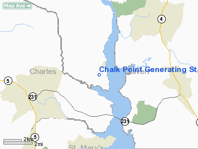
Chalk Point Generating Sta Heliport |
Location & QuickFacts
| FAA Information Effective: | 2008-09-25 |
| Airport Identifier: | MD27 |
| Airport Status: | Operational |
| Longitude/Latitude: | 076-41-33.8670W/38-33-23.4360N
-76.692741/38.556510 (Estimated) |
| Elevation: | 80 ft / 24.38 m (Estimated) |
| Land: | 0 acres |
| From nearest city: | 1 nautical miles SW of Eagle Harbor, MD |
| Location: | Prince Georges County, MD |
| Magnetic Variation: | 10W (1985) |
Owner & Manager
| Ownership: | Privately owned |
| Owner: | Potomac Electric Power Co. |
| Address: | 1900 Penn Ave Nw
Washington, DC 20068 |
| Manager: | H C Edmonds |
| Address: |
Aquasco, MD 20608 |
| Phone number: | 301-843-4100
EXT. 135-121 |
Airport Operations and Facilities
| Airport Use: | Private |
| Wind indicator: | No |
| Segmented Circle: | No |
| Control Tower: | No |
| Landing fee charge: | No |
| Sectional chart: | Washington |
| Region: | AEA - Eastern |
| Boundary ARTCC: | ZDC - Washington |
| Tie-in FSS: | DCA - Leesburg |
| FSS on Airport: | No |
| FSS Toll Free: | 1-800-WX-BRIEF |
Airport Services
| Airframe Repair: | NONE |
| Power Plant Repair: | NONE |
Runway Information
Helipad H1
| Dimension: | 330 x 130 ft / 100.6 x 39.6 m |
| Surface: | TURF, |
| |
Runway H1 |
Runway |
| Traffic Pattern: | Left | Left |
|
Radio Navigation Aids
| ID |
Type |
Name |
Ch |
Freq |
Var |
Dist |
| VKX | NDB | Potomac | | 241.00 | 10W | 16.9 nm |
| DC | NDB | Oxonn | | 332.00 | 11W | 20.1 nm |
| NHK | NDB | Patuxent | | 400.00 | 10W | 21.2 nm |
| GTN | NDB | Georgetown | | 323.00 | 09W | 30.2 nm |
| CGE | NDB | Cambridge | | 355.00 | 10W | 31.1 nm |
| BUH | NDB | Anne Arundel | | 260.00 | 10W | 31.9 nm |
| ESN | NDB | Easton | | 212.00 | 10W | 32.8 nm |
| EZF | NDB | Shannon | | 237.00 | 10W | 39.7 nm |
| APH | NDB | A P Hill | | 396.00 | 10W | 41.0 nm |
| GAI | NDB | Gaithersburg | | 385.00 | 09W | 43.0 nm |
| IUB | NDB | Institute | | 404.00 | 08W | 44.0 nm |
| FND | NDB | Ellicott | | 371.00 | 11W | 44.1 nm |
| MTN | NDB | Martin | | 342.00 | 11W | 47.0 nm |
| MTN | TACAN | Martin | 068X | | 11W | 48.4 nm |
| DCA | VOR/DME | Washington | 047X | 111.00 | 09W | 24.3 nm |
| OTT | VORTAC | Nottingham | 084X | 113.70 | 10W | 9.3 nm |
| ADW | VORTAC | Andrews | 078X | 113.10 | 10W | 17.1 nm |
| PXT | VORTAC | Patuxent | 123X | 117.60 | 10W | 21.2 nm |
| BRV | VORTAC | Brooke | 092X | 114.50 | 09W | 33.8 nm |
| BAL | VORTAC | Baltimore | 098X | 115.10 | 11W | 37.0 nm |
| AML | VORTAC | Armel | 082X | 113.50 | 08W | 42.8 nm |
| ADW | VOT | Andrews Afb | | 109.60 | | 16.5 nm |
| DCA | VOT | Washington National | | 109.40 | | 23.6 nm |
Images and information placed above are from
http://www.airport-data.com/airport/MD27/
We thank them for the data!
| General Info
|
| Country |
United States
|
| State |
MARYLAND
|
| FAA ID |
MD27
|
| Latitude |
38-33-23.436N
|
| Longitude |
076-41-33.867W
|
| Elevation |
80 feet
|
| Near City |
EAGLE HARBOR
|
We don't guarantee the information is fresh and accurate. The data may
be wrong or outdated.
For more up-to-date information please refer to other sources.
|
|


