 |
|
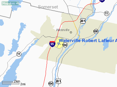
Waterville Robert Lafleur Airport |
| Waterville Robert Lafleur Airport |
| IATA: WVL – ICAO: KWVL – FAA LID: WVL |
| Summary |
| Airport type |
Public |
| Operator |
City of Waterville |
| Location |
Waterville, Maine |
| Elevation AMSL |
333 ft / 101.5 m |
| Coordinates |
44°32′0″N 69°40′32″W / 44.533333°N 69.67556°W / 44.533333; -69.67556Coordinates: 44°32′0″N 69°40′32″W / 44.533333°N 69.67556°W / 44.533333; -69.67556 |
| Runways |
| Direction |
Length |
Surface |
| ft |
m |
| 5/23 |
5,500 |
1,676 |
Asphalt |
| 14/32 |
2,301 |
701 |
Cracked/broken asphalt, CLOSED |
Waterville Robert Lafleur Airport (IATA: WVL, ICAO: KWVL, FAA LID: WVL) is a general aviation airport located two miles (3 km) southwest of the central business district (CBD) of Waterville, a city in Kennebec County, Maine, USA. The airport covers 350 acres (142 ha) and has one open runway.
It is currently not served by any commercial service, though scheduled air service was once available on Air New England and Northeast Express Regional Airlines.
The above content comes from Wikipedia and is published under free licenses – click here to read more.
Location & QuickFacts
| FAA Information Effective: | 2008-09-25 |
| Airport Identifier: | WVL |
| Airport Status: | Operational |
| Longitude/Latitude: | 069-40-31.9000W/44-31-59.7000N
-69.675528/44.533250 (Estimated) |
| Elevation: | 333 ft / 101.50 m (Surveyed) |
| Land: | 375 acres |
| From nearest city: | 2 nautical miles SW of Waterville, ME |
| Location: | Kennebec County, ME |
| Magnetic Variation: | 18W (1995) |
Owner & Manager
| Ownership: | Publicly owned |
| Owner: | City Of Waterville |
| Address: | City Hall, 1 Common St
Waterville, ME 04901 |
| Phone number: | 207-680-4203 |
| Manager: | Creg Brown |
| Address: | City Hall, 1 Common Street
Waterville, ME 04901 |
| Phone number: | 207-861-8013
OR EVENINGS 207-314-2427. |
Airport Operations and Facilities
| Airport Use: | Open to public |
| Wind indicator: | Yes |
| Segmented Circle: | Yes |
| Control Tower: | No |
| Lighting Schedule: | DUSK-DAWN
ACTVT HIRL RY 05/23; MALSF RY 05 - CTAF; MIRL RY 14/32 OPERS DUSK-DAWN. |
| Beacon Color: | Clear-Green (lighted land airport) |
| Landing fee charge: | No |
| Sectional chart: | Montreal |
| Region: | ANE - New England |
| Boundary ARTCC: | ZBW - Boston |
| Tie-in FSS: | BGR - Bangor |
| FSS on Airport: | No |
| FSS Toll Free: | 1-800-WX-BRIEF |
| NOTAMs Facility: | WVL (NOTAM-d service avaliable) |
| Federal Agreements: | NGY3 |
Airport Communications
| CTAF: | 122.700 |
| Unicom: | 122.700 |
Airport Services
| Fuel available: | 100LLA |
| Airframe Repair: | NONE |
| Power Plant Repair: | NONE |
| Bottled Oxygen: | NONE |
| Bulk Oxygen: | NONE |
Runway Information
Runway 05/23
| Dimension: | 5500 x 100 ft / 1676.4 x 30.5 m |
| Surface: | ASPH, Poor Condition
LONGITUDNAL CRACKS & VEGETATION GROWING THROUGH RY ASPHALT.
SURFACE IS CRACKED WITH WEEDS. |
| Weight Limit: | Single wheel: 40000 lbs.
Dual wheel: 60000 lbs.
Dual tandem wheel: 105000 lbs. |
| Edge Lights: | High |
| |
Runway 05 |
Runway 23 |
| Longitude: | 069-40-50.2800W | 069-40-13.9600W |
| Latitude: | 44-31-35.4680N | 44-32-23.1600N |
| Elevation: | 268.00 ft | 333.00 ft |
| Alignment: | 29 | 127 |
| ILS Type: | ILS/DME
| |
| Traffic Pattern: | Left | Left |
| Markings: | Precision instrument, Good Condition | Precision instrument, Good Condition |
| Crossing Height: | 51.00 ft | 0.00 ft |
| VASI: | 4-box on left side | 2-box on left side |
| Visual Glide Angle: | 3.00° | 0.00° |
| Approach lights: | MALSF | |
| Runway End Identifier: | No | Yes |
| Centerline Lights: | No | No |
| Touchdown Lights: | No | No |
|
Runway 14/32
| Dimension: | 2301 x 150 ft / 701.3 x 45.7 m |
| Surface: | ASPH, Poor Condition
LONGITUDNAL CRACKS & VEGETATION GROWING THROUGH RY ASPHALT.
SURFACE IS CRACKED WITH WEEDS. |
| Weight Limit: | Single wheel: 25000 lbs. |
| Edge Lights: | Medium |
| |
Runway 14 |
Runway 32 |
| Longitude: | 069-40-44.1990W | 069-40-18.2600W |
| Latitude: | 44-32-07.2210N | 44-31-54.1120N |
| Elevation: | 308.00 ft | 299.00 ft |
| Alignment: | 125 | 127 |
| Traffic Pattern: | Left | Left |
| Markings: | Basic, Good Condition
RY HOLD POSTION MARKINGS MISSING. | Basic, Good Condition |
| Runway End Identifier: | No | No |
| Centerline Lights: | No | No |
| Touchdown Lights: | No | No |
| Obstruction: | 25 ft trees, 543.0 ft from runway, 75 ft right of centerline, 13:1 slope to clear | 6 ft brush, 250.0 ft from runway, 8:1 slope to clear |
|
Radio Navigation Aids
| ID |
Type |
Name |
Ch |
Freq |
Var |
Dist |
| RL | NDB | Bracy | | 399.00 | 18W | 5.1 nm |
| BUP | NDB | Burnham | | 348.00 | 18W | 16.8 nm |
| BST | NDB | Belfast | | 278.00 | 18W | 29.4 nm |
| ISS | NDB | Wiscasset | | 407.00 | 18W | 33.1 nm |
| SUH | NDB | Sprucehead | | 356.00 | 18W | 38.0 nm |
| NHZ | TACAN | Brunswick | 099X | | 17W | 41.1 nm |
| AUG | VOR/DME | Augusta | 051X | 111.40 | 18W | 13.8 nm |
| BGR | VORTAC | Bangor | 095X | 114.80 | 19W | 39.0 nm |
| BGR | VOT | Bangor | | 111.00 | | 40.4 nm |
Remarks
- NUMEROUS SEA GULLS ON AND WITHIN 1-1/2 MI AREA OF ARPT.
- DEER ON & INVOF ARPT.
- WILD TURKEYS WITHIN ARPT PERIMETER FENCE.
- HELICOPTER OPNS PAVED AREA ONLY.
- AVOID HOSPITAL 1 MILE NORTH.
- EXISTED PRIOR TO 1959.
Images and information placed above are from
http://www.airport-data.com/airport/WVL/
We thank them for the data!
| General Info
|
| Country |
United States
|
| State |
MAINE
|
| FAA ID |
WVL
|
| Latitude |
44-31-59.700N
|
| Longitude |
069-40-31.900W
|
| Elevation |
333 feet
|
| Near City |
WATERVILLE
|
We don't guarantee the information is fresh and accurate. The data may
be wrong or outdated.
For more up-to-date information please refer to other sources.
|
|


