 |
|
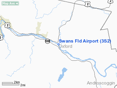
Location & QuickFacts
| FAA Information Effective: | 2008-09-25 |
| Airport Identifier: | 3S2 |
| Airport Status: | Operational |
| Longitude/Latitude: | 070-24-24.5000W/44-30-50.9000N
-70.406806/44.514139 (Estimated) |
| Elevation: | 400 ft / 121.92 m (Estimated) |
| Land: | 30 acres |
| From nearest city: | 3 nautical miles SE of Dixfield, ME |
| Location: | Oxford County, ME |
| Magnetic Variation: | 18W (1985) |
Owner & Manager
| Ownership: | Privately owned |
| Owner: | Royal Swan |
| Address: | Rr 2, Box 2475
Dixfield, ME 04224 |
| Phone number: | 207-562-4758 |
| Manager: | Royal Swan |
| Address: | Rr 2, Box 2475
Dixfield, ME 04224 |
| Phone number: | 207-562-4758 |
Airport Operations and Facilities
| Airport Use: | Open to public |
| Wind indicator: | Yes |
| Segmented Circle: | No |
| Control Tower: | No |
| Landing fee charge: | No |
| Sectional chart: | Montreal |
| Region: | ANE - New England |
| Boundary ARTCC: | ZBW - Boston |
| Tie-in FSS: | BGR - Bangor |
| FSS on Airport: | No |
| FSS Toll Free: | 1-800-WX-BRIEF |
| NOTAMs Facility: | BGR (NOTAM-d service avaliable) |
Airport Communications
Airport Services
| Airframe Repair: | NONE |
| Power Plant Repair: | NONE |
Runway Information
Runway 12/30
| Dimension: | 1808 x 40 ft / 551.1 x 12.2 m |
| Surface: | TURF, Good Condition |
| |
Runway 12 |
Runway 30 |
| Longitude: | 070-24-35.2991W | 070-24-13.7906W |
| Latitude: | 44-30-55.4623N | 44-30-46.4213N |
| Elevation: | 418.00 ft | 418.00 ft |
| Alignment: | 121 | 127 |
| Traffic Pattern: | Left | Left |
| Obstruction: | 55 ft trees, 65 ft right of centerline | 4 ft berm, 0.0 ft from runway |
|
Radio Navigation Aids
| ID |
Type |
Name |
Ch |
Freq |
Var |
Dist |
| SZO | FAN MARKER | Grinn | | | 17W | 39.2 nm |
| RL | NDB | Bracy | | 399.00 | 18W | 29.0 nm |
| RQM | NDB | Rangeley | | 221.00 | 18W | 29.2 nm |
| HXK | NDB | Hornebrook | | 281.00 | 17W | 33.3 nm |
| SZO | NDB | Sebago | | 227.00 | 17W | 40.1 nm |
| ISS | NDB | Wiscasset | | 407.00 | 18W | 45.9 nm |
| BUP | NDB | Burnham | | 348.00 | 18W | 46.2 nm |
| NHZ | TACAN | Brunswick | 099X | | 17W | 43.8 nm |
| AUG | VOR/DME | Augusta | 051X | 111.40 | 18W | 28.7 nm |
| BML | VOR/DME | Berlin | 041X | 110.40 | 17W | 34.1 nm |
Remarks
- CONTACT AMGR FOR RY CONDITIONS IN WINTER.
- IN ACCORD W/VFR.
Images and information placed above are from
http://www.airport-data.com/airport/3S2/
We thank them for the data!
| General Info
|
| Country |
United States
|
| State |
MAINE
|
| FAA ID |
3S2
|
| Latitude |
44-30-50.900N
|
| Longitude |
070-24-24.500W
|
| Elevation |
400 feet
|
| Near City |
DIXFIELD
|
We don't guarantee the information is fresh and accurate. The data may
be wrong or outdated.
For more up-to-date information please refer to other sources.
|
|


