 |
|
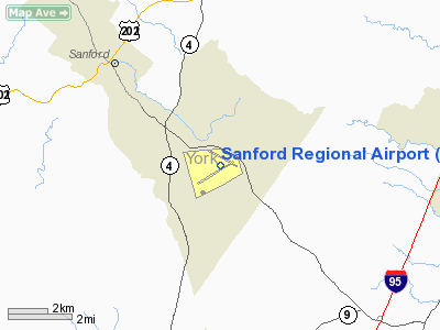
| Sanford Regional Airport |
| IATA: SFM – ICAO: KSFM – FAA LID: SFM |
| Summary |
| Airport type |
Public |
| Owner |
Town of Sanford |
| Location |
Sanford, Maine |
| Elevation AMSL |
244 ft / 74 m |
| Coordinates |
43°23′38″N 070°42′29″W / 43.39389°N 70.70806°W / 43.39389; -70.70806 |
| Runways |
| Direction |
Length |
Surface |
| ft |
m |
| 7/25 |
6,000 |
1,829 |
Asphalt |
| 14/32 |
4,999 |
1,524 |
Asphalt |
| Statistics (2006) |
| Aircraft operations |
76,010 |
| Based aircraft |
78 |
| Source: Federal Aviation Administration |
Sanford Regional Airport (IATA: SFM, ICAO: KSFM, FAA LID: SFM) is a public airport located four miles (6 km) southeast of the central business district of Sanford, a town in York County, Maine, United States. This airport is publicly owned by Town of Sanford. Facilities and aircraft
Sanford Regional Airport covers an area of 1,115 acres (451 ha) which contains two runways:
- Runway 7/25: 6,000 x 150 ft (1,829 x 46 m), Surface: Asphalt
- Runway 14/32: 4,999 x 100 ft (1,524 x 30 m), Surface: Asphalt
For 12-month period ending 29 August 2006 the airport had 76,010 aircraft operations, an average of 208 per day: 96% general aviation (72,640), 4% air taxi (3,350) and <1% military (20). There are 78 aircraft based at this airport: 92% single engine (72) and 8% multi engine (6).
Facts
Both George Bush and George H. W. Bush frequently fly into Sanford Regional airport in the summer months as they have a house in Kennebunkport, Maine.
The above content comes from Wikipedia and is published under free licenses – click here to read more.
Location & QuickFacts
| FAA Information Effective: | 2008-09-25 |
| Airport Identifier: | SFM |
| Airport Status: | Operational |
| Longitude/Latitude: | 070-42-28.8010W/43-23-37.9000N
-70.708000/43.393861 (Estimated) |
| Elevation: | 244 ft / 74.37 m (Surveyed) |
| Land: | 1115 acres |
| From nearest city: | 4 nautical miles SE of Sanford, ME |
| Location: | York County, ME |
| Magnetic Variation: | 17W (1990) |
Owner & Manager
| Ownership: | Publicly owned |
| Owner: | Town Of Sanford |
| Address: | 919 Main Street
Sanford, ME 04073 |
| Phone number: | 207-432-0596 |
| Manager: | Evan R. Mc Dougal |
| Address: | 919 Main St
Sanford, ME 04073 |
| Phone number: | 207-432-0596
ALTERNATE 207-324-8695 |
Airport Operations and Facilities
| Airport Use: | Open to public |
| Wind indicator: | Yes |
| Segmented Circle: | Yes |
| Control Tower: | No |
| Lighting Schedule: | DUSK-DAWN
ACTVT HIRL RY 07/25; MIRL RY 14/32; PAPI & REIL RY 07; ODALS RY 25 & TWY E - CTAF. |
| Beacon Color: | Clear-Green (lighted land airport) |
| Landing fee charge: | No |
| Sectional chart: | New York |
| Region: | ANE - New England |
| Boundary ARTCC: | ZBW - Boston |
| Tie-in FSS: | BGR - Bangor |
| FSS on Airport: | No |
| FSS Toll Free: | 1-800-WX-BRIEF |
| NOTAMs Facility: | SFM (NOTAM-d service avaliable) |
| Federal Agreements: | NGPR3Y |
Airport Communications
| CTAF: | 123.075 |
| Unicom: | 123.075 |
Airport Services
| Fuel available: | 100LLA |
| Airframe Repair: | MAJOR |
| Power Plant Repair: | MAJOR |
| Bottled Oxygen: | HIGH/LOW |
| Bulk Oxygen: | NONE |
Runway Information
Runway 07/25
| Dimension: | 6000 x 150 ft / 1828.8 x 45.7 m |
| Surface: | ASPH, Fair Condition |
| Weight Limit: | Single wheel: 50000 lbs.
Dual wheel: 82000 lbs. |
| Edge Lights: | High |
| |
Runway 07 |
Runway 25 |
| Longitude: | 070-43-09.2490W | 070-42-00.0610W |
| Latitude: | 43-23-12.8460N | 43-23-43.9210N |
| Elevation: | 238.00 ft | 233.00 ft |
| Alignment: | 58 | 127 |
| ILS Type: | ILS
| |
| Traffic Pattern: | Left | Left |
| Markings: | Precision instrument, Fair Condition | Non-precision instrument, Fair Condition |
| Crossing Height: | 42.00 ft | 59.00 ft |
| VASI: | 4-light PAPI on left side | 4-box on left side |
| Visual Glide Angle: | 3.00° | 3.00° |
| Approach lights: | | ODALS |
| Runway End Identifier: | Yes | |
| Centerline Lights: | No | No |
| Touchdown Lights: | No | No |
|
Runway 14/32
| Dimension: | 4999 x 100 ft / 1523.7 x 30.5 m |
| Surface: | ASPH, Good Condition |
| Weight Limit: | Dual wheel: 72000 lbs. |
| Edge Lights: | Medium |
| |
Runway 14 |
Runway 32 |
| Longitude: | 070-42-51.5030W | 070-41-52.2270W |
| Latitude: | 43-24-01.2350N | 43-23-37.3660N |
| Elevation: | 244.00 ft | 231.00 ft |
| Alignment: | 119 | 127 |
| Traffic Pattern: | Left | Left |
| Markings: | Basic, Fair Condition | Basic, Fair Condition |
| Crossing Height: | 23.00 ft | 36.00 ft |
| Displaced threshold: | 896.00 ft | 0.00 ft |
| VASI: | 4-light PAPI on left side | 4-light PAPI on left side |
| Visual Glide Angle: | 4.00° | 3.00° |
| Runway End Identifier: | No | No |
| Centerline Lights: | No | No |
| Touchdown Lights: | No | No |
| Obstruction: | 44 ft tree, 480.0 ft from runway, 125 ft right of centerline, 6:1 slope to clear
APCH RATIO 26:1 TO DSPLCD THLD. | 45 ft tree, 1235.0 ft from runway, 125 ft right of centerline, 23:1 slope to clear |
|
Radio Navigation Aids
| ID |
Type |
Name |
Ch |
Freq |
Var |
Dist |
| LCI | FAN MARKER | Laconia | | | | 33.6 nm |
| SZO | FAN MARKER | Grinn | | | 17W | 34.7 nm |
| BVY | FAN MARKER | Beverly | | | | 48.2 nm |
| PH | MARINE NDB | Portland Lhb-p | | 301.00 | 17W | 28.1 nm |
| ESG | NDB | Rollins | | 260.00 | 16W | 11.7 nm |
| SZO | NDB | Sebago | | 227.00 | 17W | 30.8 nm |
| CO | NDB | Epsom | | 216.00 | 16W | 36.5 nm |
| LC | NDB | Blnap | | 328.00 | 16W | 37.2 nm |
| DRY | NDB | Derry | | 338.00 | 16W | 43.7 nm |
| TOF | NDB | Topsfield | | 269.00 | 16W | 47.8 nm |
| NHZ | TACAN | Brunswick | 099X | | 17W | 44.7 nm |
| PSM | VOR/DME | Pease | 112X | 116.50 | 16W | 19.4 nm |
| LWM | VOR/DME | Lawrence | 072X | 112.50 | 15W | 42.8 nm |
| MHT | VOR/DME | Manchester | 091X | 114.40 | 15W | 42.9 nm |
| ENE | VORTAC | Kennebunk | 118X | 117.10 | 17W | 4.5 nm |
| CON | VORTAC | Concord | 076X | 112.90 | 15W | 39.4 nm |
| PWM | VOT | Portland Intl Jetport | | 111.00 | | 22.6 nm |
Remarks
- WILDLIFE ON & INVOF ARPT.
- CALM WIND PREFERRED RY 32.
- EXISTED PRIOR TO 1959.
Images and information placed above are from
http://www.airport-data.com/airport/SFM/
We thank them for the data!
| General Info
|
| Country |
United States
|
| State |
MAINE
|
| FAA ID |
SFM
|
| Latitude |
43-23-37.900N
|
| Longitude |
070-42-28.801W
|
| Elevation |
244 feet
|
| Near City |
SANFORD
|
We don't guarantee the information is fresh and accurate. The data may
be wrong or outdated.
For more up-to-date information please refer to other sources.
|
|


