|
 |
|
||||
|
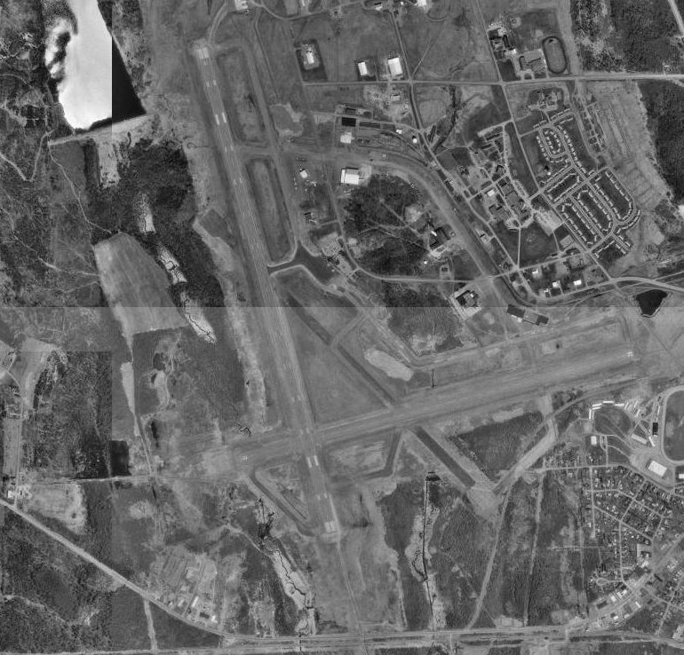
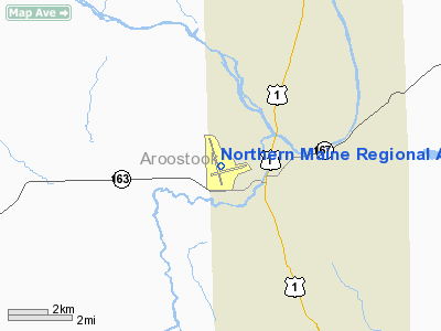
Landing runway 1 at PQI. Northern Maine Regional Airport at Presque Isle (IATA: PQI, ICAO: KPQI, FAA LID: PQI) is a city-owned public-use airport located one nautical mile (2 km) northwest of the central business district of Presque Isle, a city in Aroostook County, Maine, United States. It serves the residents of Presque Isle, Maine, and a vast area of northern Maine and northwestern New Brunswick with commercial and charter aviation services. Airline service is subsidized by the Essential Air Service program. The airport is home to the second longest commercial runway in Maine (second only to Bangor International Airport), and third longest overall (after the Loring Commerce Centre, formerly Loring Air Force Base) and is often advertised as the "Gateway to Northern Maine." The airport was once hub to Aroostook Airways, a commuter airline which operated in the 1970s, with service to several destinations throughout New England. HistoryWorld War TwoDuring World War II, the federal government appropriated the airport, establishing an air base for planes bound to and from Great Britain. Lane Construction of Hampden, Maine, was one of the contractors who worked on upgrading the airport for the military. Floyd E. Brown of Hermon, Maine, was one of the foreman and would take airplane rides at the end of the day to gauge his progress against the other foreman. (He would later serve in the US Army as a Staff Sergeant/section chief of the 60mm mortars (C Co., 328th Regimental Combat Team, 26th ID.)) Almost overnight, Presque Isle Army Airfield became a vital air transport installation and the city found itself a busy war center. During the Second World War, Clark Gable was briefly stationed at Presque Isle before being sent to England. Operations during this period were described by Ernest K. Gann, based upon his personal experiences in the Air Transport Command, in his book, Fate Is The Hunter. Post warWhen the United States Air Force closed Presque Isle Air Force Base in 1961, the former Air Force Base was redeveloped. Presque Isle is home the University of Maine at Presque Isle, as well as the Northern Maine Community College. Scheduled commercial air service is available through Northern Maine Regional Airport in Presque Isle. General aviation services are available through both Northern Maine Regional Airport and Caribou Municipal Airport. In addition, the Skyway Industrial Park sits adjacent to Northern Maine Regional Airport which offers commercial airline as well as general aviation services to the entire region. FedEx and United Parcel Service augment park accessibility by air to and from major markets. Skyway Industrial Park, owned by the city of Presque Isle and administered by the Presque Isle Industrial Council, has been attractive to a variety of new businesses. To date, over 40 companies have located on the park. The park consists of 440 acres, of which 175 is prime industrial land served by all utilities, streets, subdivided and available for further development. Located adjacent to the airport and within 1.5 miles of downtown, the park has become a dominant feature in the local and regional economy. Facilities and aircraftNorthern Maine Regional Airport at Presque Isle covers an area of 1,489 acres (603 ha) at an elevation of 534 feet (163 m) above mean sea level. It has two asphalt paved runways: 1/19 measuring 7,439 by 150 feet (2,267 by 46 m) and 10/28 measuring 5,994 by 150 feet (1,827 by 46 m). For the 12-month period ending July 31, 2007, the airport had 4,684 aircraft operations, an average of 12 per day: 49% general aviation, 42% scheduled commercial, 7% air taxi and 2% military. At that time there were 22 aircraft based at this airport: 77% single-engine and 23% multi-engine. Aircraft servicing Presque Isle include: Saab 340 operated by US Airways Express; Cessna 208 Caravan and Beechcraft C99 operated by Wiggins Airways; and Embraer 110 Bandeirante operated by AirNow. Airlines and destinations
Air cargo operators and destinations
The above content comes from Wikipedia and is published under free licenses – click here to read more.
Location & QuickFacts
Owner & Manager
Airport Operations and Facilities
Airport Communications
Airport Services
Runway InformationRunway 01/19
Runway 10/28
Radio Navigation Aids
Remarks
Images and information placed above are from We thank them for the data!
We don't guarantee the information is fresh and accurate. The data may
be wrong or outdated.
|
||||||||||||||||||||||||||||||||||||||||||||||||||||||||||||||||||||||||||||||||||||||||||||||||||||||||||||||||||||||||||||||||||||||||||||||||||||||||||||||||||||||||||||||||||||||||||||||||||||||||||||||||||||||||||||||||||||||||||||||||||||||||||||||||||||||||||||||||||||||||||||||||||||||||||||||||||||||||||||||||||||||||||||||||||||||||||||||||||||||||||||||||

 |
|
Copyright 2004-2024 © by Airports-Worldwide.com, Vyshenskoho st. 36, Lviv 79010, Ukraine Legal Disclaimer |