 |
|
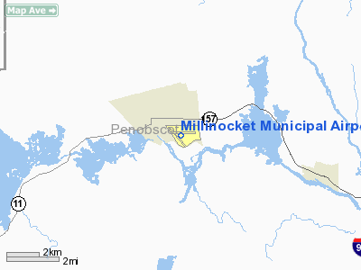
Millinocket Municipal Airport |
| Millinocket Municipal Airport |
| IATA: MLT – ICAO: KMLT – FAA LID: MLT |
| Summary |
| Airport type |
Public |
| Owner |
Town of Millinocket |
| Serves |
Millinocket, Maine |
| Elevation AMSL |
408 ft / 124 m |
| Coordinates |
45°38′52″N 068°41′08″W / 45.64778°N 68.68556°W / 45.64778; -68.68556 |
| Runways |
| Direction |
Length |
Surface |
| ft |
m |
| 11/29 |
4,713 |
1,437 |
Asphalt |
| 16/34 |
4,008 |
1,222 |
Asphalt |
| Statistics (2006) |
| Aircraft operations |
7,700 |
| Based aircraft |
15 |
| Source: Federal Aviation Administration |
Millinocket Municipal Airport (IATA: MLT, ICAO: KMLT, FAA LID: MLT) is a town-owned, public-use airport located one nautical mile (2 km) southeast of the central business district of Millinocket, a town in Penobscot County, Maine, United States. It once offered commercial airline service on Northeast Airlines. Facilities and aircraft
Millinocket Municipal Airport covers an area of 322 acres (130 ha) at an elevation of 408 feet (124 m) above mean sea level. It has two asphalt paved runways: 11/29 measuring 4,713 x 100 feet (1,437 x 30 m) and 16/34 measuring 4,008 x 100 feet (1,222 x 30 m).
For the 12-month period ending August 18, 2006, the airport had 7,700 aircraft operations, an average of 21 per day: 82% general aviation, 13% military and 5% air taxi. At that time there were 15 aircraft based at this airport: 93% single-engine and 7% ultralight.
The above content comes from Wikipedia and is published under free licenses – click here to read more.
Location & QuickFacts
| FAA Information Effective: | 2008-09-25 |
| Airport Identifier: | MLT |
| Airport Status: | Operational |
| Longitude/Latitude: | 068-41-08.0230W/45-38-52.2100N
-68.685562/45.647836 (Estimated) |
| Elevation: | 408 ft / 124.36 m (Surveyed) |
| Land: | 322 acres |
| From nearest city: | 1 nautical miles SE of Millinocket, ME |
| Location: | Penobscot County, ME |
| Magnetic Variation: | 20W (1965) |
Owner & Manager
| Ownership: | Publicly owned |
| Owner: | Town Of Millinocket |
| Address: | 197 Penobscot Ave
Millinocket, ME 04462 |
| Phone number: | 207-723-6649 |
| Manager: | Town Of Millinocket |
| Address: | Millinocket Municipal Arpt.,, 16 Medway Rd.
Millinocket, ME 04462 |
| Phone number: | 207-723-6649 |
Airport Operations and Facilities
| Airport Use: | Open to public |
| Wind indicator: | Yes |
| Segmented Circle: | No |
| Control Tower: | No |
| Lighting Schedule: | DUSK-DAWN
ACTVT MIRL RY 11/29; REIL RY 11 & VASI RY 29 - CTAF. |
| Beacon Color: | Clear-Green (lighted land airport) |
| Landing fee charge: | No |
| Sectional chart: | Halifax |
| Region: | ANE - New England |
| Boundary ARTCC: | ZBW - Boston |
| Tie-in FSS: | BGR - Bangor |
| FSS on Airport: | No |
| FSS Toll Free: | 1-800-WX-BRIEF |
| NOTAMs Facility: | MLT (NOTAM-d service avaliable) |
| Federal Agreements: | NGY3 |
Airport Communications
| CTAF: | 122.800 |
| Unicom: | 122.800 |
Airport Services
| Fuel available: | 100LLA
FUEL AVBL 24 HRS, CALL 207-723-4375. |
| Airframe Repair: | NONE |
| Power Plant Repair: | NONE |
| Bottled Oxygen: | NONE |
| Bulk Oxygen: | NONE |
Runway Information
Runway 11/29
| Dimension: | 4713 x 100 ft / 1436.5 x 30.5 m |
| Surface: | ASPH, Good Condition |
| Weight Limit: | Single wheel: 30000 lbs.
Dual wheel: 44000 lbs. |
| Edge Lights: | Medium |
| |
Runway 11 |
Runway 29 |
| Longitude: | 068-41-34.0626W | 068-40-27.7232W |
| Latitude: | 45-38-57.7405N | 45-38-57.4458N |
| Elevation: | 401.00 ft | 395.00 ft |
| Alignment: | 90 | 127 |
| ILS Type: | | LOCALIZER
|
| Traffic Pattern: | Left | Left |
| Markings: | Basic, Fair Condition | Non-precision instrument, Fair Condition |
| Crossing Height: | 0.00 ft | 51.00 ft |
| VASI: | | 4-box on right side |
| Visual Glide Angle: | 0.00° | 3.00° |
| Runway End Identifier: | Yes | No |
| Centerline Lights: | No | No |
| Touchdown Lights: | No | No |
| Obstruction: | 35 ft trees, 428.0 ft from runway, 240 ft right of centerline, 7:1 slope to clear | 50 ft trees, 1250.0 ft from runway, 270 ft left of centerline, 21:1 slope to clear
16' TREES 110' FROM THRESHOLD 100' R, 8-12' BRUSH 120' FROM THRESHOLD 125' L |
|
Runway 16/34
| Dimension: | 4008 x 100 ft / 1221.6 x 30.5 m |
| Surface: | ASPH, Good Condition |
| Weight Limit: | Single wheel: 30000 lbs.
Dual wheel: 44000 lbs. |
| |
Runway 16 |
Runway 34 |
| Longitude: | 068-41-34.8866W | 068-40-57.8333W |
| Latitude: | 45-39-00.7694N | 45-38-30.9376N |
| Elevation: | 400.00 ft | 380.00 ft |
| Alignment: | 127 | 127 |
| Traffic Pattern: | Left | Left |
| Markings: | Basic, Fair Condition | Basic, Fair Condition |
| Runway End Identifier: | No | No |
| Centerline Lights: | No | No |
| Touchdown Lights: | No | No |
| Obstruction: | 55 ft trees, 1350.0 ft from runway, 100 ft right of centerline, 21:1 slope to clear | 20 ft trees, 279.0 ft from runway, 75 ft left of centerline, 4:1 slope to clear |
|
Radio Navigation Aids
| ID |
Type |
Name |
Ch |
Freq |
Var |
Dist |
| LNT | NDB | Milnot | | 344.00 | 19W | 5.7 nm |
| LRG | NDB | Lincoln | | 216.00 | 19W | 18.6 nm |
| OLD | NDB | Old Town | | 272.00 | 20W | 38.6 nm |
| XQA | NDB | Squaw | | 236.00 | 18W | 42.3 nm |
| MLT | VOR/DME | Millinocket | 126X | 117.90 | 20W | 8.0 nm |
| HUL | VOR/DME | Houlton | 108X | 116.10 | 21W | 42.7 nm |
| PNN | VOR/DME | Princeton | 090X | 114.30 | 21W | 45.6 nm |
| BGR | VORTAC | Bangor | 095X | 114.80 | 19W | 49.1 nm |
Remarks
- RY 16/34 CLSD WINTER MONTHS EXCP SKI ACFT; SNOWBANK CROSSES INTXN RY 16/34 AT RY 11/29 & ALONG 1000 FT TWY PLOWED CNTR OF RY 16/34 FROM INTXN TO SOUTH TWY TO RAMP.
- RY 11 APCH HAS SEVERAL LGTD STACKS 180FT-270 FT ABOVE RY END ELEVATION 2800 FT FM RY END & IMMEDIATELY R OF APCH.
- RY 11/29 HAS 15-20 FT TREES & BRUSH PARALLEL TO RY BOTH SIDES 240 FT FM CNTRLN.
- EXISTED PRIOR TO 1959.
Images and information placed above are from
http://www.airport-data.com/airport/MLT/
We thank them for the data!
| General Info
|
| Country |
United States
|
| State |
MAINE
|
| FAA ID |
MLT
|
| Latitude |
45-38-52.210N
|
| Longitude |
068-41-08.023W
|
| Elevation |
408 feet
|
| Near City |
MILLINOCKET
|
We don't guarantee the information is fresh and accurate. The data may
be wrong or outdated.
For more up-to-date information please refer to other sources.
|
|


