 |
|
Lucky Landing Marina And Spb Seaplane Base |
| Lucky Landing Marina and Seaplane Base |
| IATA: none – ICAO: none – FAA LID: 06B |
| Summary |
| Airport type |
Public |
| Owner |
Timothy D. Hodgkins |
| Serves |
Bangor, Maine |
| Elevation AMSL |
115 ft / 35 m |
| Coordinates |
44°54′25″N 068°48′18″W / 44.90694°N 68.805°W / 44.90694; -68.805 |
| Runways |
| Direction |
Length |
Surface |
| ft |
m |
| 2/20 |
15,000 |
4,572 |
Water |
| Statistics (2006) |
| Aircraft operations |
1,850 |
| Source: Federal Aviation Administration |
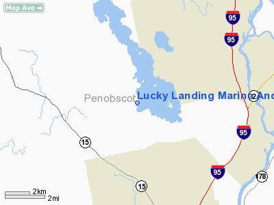
Lucky Landing Marina and Seaplane Base (FAA LID: 06B) is a privately-owned, public-use seaplane base located seven nautical miles (13 km) north of the central business district of Bangor, a city in Penobscot County, Maine, United States. It is located on Pushaw Lake.
Facilities and aircraft
Lucky Landing Marina and Seaplane Base has one landing area designated 2/20 which measures 15,000 x 4,000 ft (4,572 x 1,219 m). For the 12-month period ending July 31, 2006, the airport had 1,850 aircraft operations, an average of 154 per month: 86% general aviation and 14% air taxi.
The above content comes from Wikipedia and is published under free licenses – click here to read more.
Location & QuickFacts
| FAA Information Effective: | 2008-09-25 |
| Airport Identifier: | 06B |
| Airport Status: | Operational |
| Longitude/Latitude: | 068-48-18.1300W/44-54-25.2480N
-68.805036/44.907013 (Estimated) |
| Elevation: | 115 ft / 35.05 m (Surveyed) |
| Land: | 0 acres |
| From nearest city: | 7 nautical miles N of Bangor, ME |
| Location: | Penobscot County, ME |
| Magnetic Variation: | 19W (1985) |
Owner & Manager
| Ownership: | Privately owned |
| Owner: | Timothy D Hodgkins |
| Address: | 35 Lucky Landing Rd
Glenburn, ME 04401 |
| Phone number: | 207-945-5087 |
| Manager: | Timothy D Hodgkins |
| Address: | 35 Lucky Landing Rd
Glenburn, ME 04401 |
| Phone number: | 207-945-5087 |
Airport Operations and Facilities
| Airport Use: | Open to public |
| Wind indicator: | Yes |
| Segmented Circle: | No |
| Control Tower: | No |
| Landing fee charge: | No |
| Sectional chart: | Halifax |
| Region: | ANE - New England |
| Boundary ARTCC: | ZBW - Boston |
| Tie-in FSS: | BGR - Bangor |
| FSS on Airport: | No |
| FSS Toll Free: | 1-800-WX-BRIEF |
| NOTAMs Facility: | BGR (NOTAM-d service avaliable) |
Airport Communications
Airport Services
| Fuel available: | 100LLMOGAS |
| Airframe Repair: | MINOR |
| Power Plant Repair: | MINOR |
Runway Information
Runway 02/20
| Dimension: | 15000 x 4000 ft / 4572.0 x 1219.2 m |
| Surface: | WATER, |
| |
Runway 02 |
Runway 20 |
| Traffic Pattern: | Right | Left |
|
Radio Navigation Aids
| ID |
Type |
Name |
Ch |
Freq |
Var |
Dist |
| OLD | NDB | Old Town | | 272.00 | 20W | 9.4 nm |
| BUP | NDB | Burnham | | 348.00 | 18W | 26.7 nm |
| LRG | NDB | Lincoln | | 216.00 | 19W | 29.3 nm |
| BH | NDB | Surry | | 330.00 | 19W | 30.7 nm |
| BST | NDB | Belfast | | 278.00 | 18W | 31.1 nm |
| LNT | NDB | Milnot | | 344.00 | 19W | 45.9 nm |
| RL | NDB | Bracy | | 399.00 | 18W | 48.0 nm |
| MLT | VOR/DME | Millinocket | 126X | 117.90 | 20W | 42.7 nm |
| BGR | VORTAC | Bangor | 095X | 114.80 | 19W | 4.9 nm |
| BGR | VOT | Bangor | | 111.00 | | 6.2 nm |
Remarks
- WATER LANDING AREA NOT MARKED.
- FILED FOR RECORD PURPOSES ONLY.
Images and information placed above are from
http://www.airport-data.com/airport/06B/
We thank them for the data!
| General Info
|
| Country |
United States
|
| State |
MAINE
|
| FAA ID |
06B
|
| Latitude |
44-54-25.248N
|
| Longitude |
068-48-18.130W
|
| Elevation |
115 feet
|
| Near City |
BANGOR
|
We don't guarantee the information is fresh and accurate. The data may
be wrong or outdated.
For more up-to-date information please refer to other sources.
|
|


