 |
|
| Lincoln Regional Airport |
| IATA: none – ICAO: KLRG – FAA LID: LRG |
| Summary |
| Airport type |
Public |
| Owner |
Town of Lincoln |
| Serves |
Lincoln, Maine |
| Elevation AMSL |
208 ft / 63 m |
| Coordinates |
45°21′44″N 068°32′05″W / 45.36222°N 68.53472°W / 45.36222; -68.53472 |
| Runways |
| Direction |
Length |
Surface |
| ft |
m |
| 17/35 |
2,804 |
855 |
Asphalt |
| 6W/24W |
2,400 |
732 |
Water |
| Statistics (2006) |
| Aircraft operations |
3,800 |
| Based aircraft |
34 |
| Source: Federal Aviation Administration |
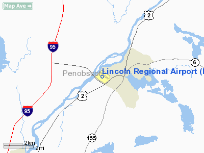
Lincoln Regional Airport (ICAO: KLRG, FAA LID: LRG) is a public airport located two nautical miles (3.7 km) southwest of the central business district of Lincoln, a town in Penobscot County, Maine, United States. It is owned by the Town of Lincoln.
Although most U.S. airports use the same three-letter location identifier for the FAA and IATA, this airport is assigned LRG by the FAA but has no designation from the IATA (which assigned LRG to Lora Lai, Pakistan).
Facilities and aircraft
Lincoln Regional Airport covers an area of 59 acres (24 ha) which contains one asphalt paved runways (17/35) measuring 2,804 x 75 ft (855 x 23 m). It also has one seaplane landing area (6W/24W) measuring 2,400 x 100 ft (732 x 30 m).
For the 12-month period ending July 31, 2006, the airport had 3,800 aircraft operations, an average of 10 per day, 100% of which were general aviation. There are 34 aircraft based at this airport: 91% single engine, 3% multi-engine and 6% ultralight.
The above content comes from Wikipedia and is published under free licenses – click here to read more.
Location & QuickFacts
| FAA Information Effective: | 2008-09-25 |
| Airport Identifier: | LRG |
| Airport Status: | Operational |
| Longitude/Latitude: | 068-32-05.0890W/45-21-43.7790N
-68.534747/45.362161 (Estimated) |
| Elevation: | 208 ft / 63.40 m (Surveyed) |
| Land: | 59 acres |
| From nearest city: | 2 nautical miles SW of Lincoln, ME |
| Location: | Penobscot County, ME |
| Magnetic Variation: | 19W (1995) |
Owner & Manager
| Ownership: | Publicly owned |
| Owner: | Town Of Lincoln |
| Address: | 63 Main Street
Lincoln, ME 04457 |
| Phone number: | 207-794-3372 |
| Manager: | Glenn Aho |
| Address: | 63 Main Street
Lincoln, ME 04457 |
| Phone number: | 207-794-3372 |
Airport Operations and Facilities
| Airport Use: | Open to public |
| Wind indicator: | Yes |
| Segmented Circle: | Yes |
| Control Tower: | No |
| Lighting Schedule: | DUSK-DAWN
ACTVT MIRL RY 17/35 - CTAF. |
| Beacon Color: | Clear-Green (lighted land airport) |
| Landing fee charge: | No |
| Sectional chart: | Halifax |
| Region: | ANE - New England |
| Boundary ARTCC: | ZBW - Boston |
| Tie-in FSS: | BGR - Bangor |
| FSS on Airport: | No |
| FSS Toll Free: | 1-800-WX-BRIEF |
| NOTAMs Facility: | BGR (NOTAM-d service avaliable) |
| Federal Agreements: | NGY |
Airport Communications
| CTAF: | 122.800 |
| Unicom: | 122.800 |
Airport Services
| Airframe Repair: | NONE |
| Power Plant Repair: | NONE |
| Bottled Oxygen: | NONE |
| Bulk Oxygen: | NONE |
Runway Information
Runway 06W/24W
| Dimension: | 2400 x 100 ft / 731.5 x 30.5 m |
| Surface: | WATER, |
| |
Runway 06W |
Runway 24W |
| Traffic Pattern: | Left | Left |
| Obstruction: | 64 ft pline, 960.0 ft from runway, 15:1 slope to clear | 94 ft trees, 1410.0 ft from runway, 15:1 slope to clear |
|
Runway 17/35
| Dimension: | 2804 x 75 ft / 854.7 x 22.9 m |
| Surface: | ASPH, Good Condition |
| Weight Limit: | Single wheel: 25000 lbs. |
| Edge Lights: | Medium |
| |
Runway 17 |
Runway 35 |
| Longitude: | 068-32-15.6910W | 068-31-54.4570W |
| Latitude: | 45-21-55.4250N | 45-21-32.1380N |
| Elevation: | 196.00 ft | 206.00 ft |
| Alignment: | 127 | 127 |
| Traffic Pattern: | Left | Left |
| Markings: | Basic, Good Condition | Basic, Good Condition |
| Obstruction: | 21 ft trees, 214.0 ft from runway, 85 ft left of centerline
+6 FT BRUSH 50 FT FM THLD 64 FT LEFT. | 35 ft trees, 613.0 ft from runway, 209 ft left of centerline, 11:1 slope to clear |
|
Radio Navigation Aids
| ID |
Type |
Name |
Ch |
Freq |
Var |
Dist |
| LRG | NDB | Lincoln | | 216.00 | 19W | 0.4 nm |
| LNT | NDB | Milnot | | 344.00 | 19W | 17.2 nm |
| OLD | NDB | Old Town | | 272.00 | 20W | 21.8 nm |
| XQA | NDB | Squaw | | 236.00 | 18W | 49.0 nm |
| MLT | VOR/DME | Millinocket | 126X | 117.90 | 20W | 13.5 nm |
| PNN | VOR/DME | Princeton | 090X | 114.30 | 21W | 35.1 nm |
| BGR | VORTAC | Bangor | 095X | 114.80 | 19W | 34.4 nm |
| BGR | VOT | Bangor | | 111.00 | | 35.5 nm |
Remarks
- 40 FT BRIDGE AT S. END WATER LDG AREA.
- VFR ONLY.
Images and information placed above are from
http://www.airport-data.com/airport/LRG/
We thank them for the data!
| General Info
|
| Country |
United States
|
| State |
MAINE
|
| FAA ID |
LRG
|
| Latitude |
45-21-43.779N
|
| Longitude |
068-32-05.089W
|
| Elevation |
208 feet
|
| Near City |
LINCOLN
|
We don't guarantee the information is fresh and accurate. The data may
be wrong or outdated.
For more up-to-date information please refer to other sources.
|
|


