|
|
Knox County Regional Airport |
| Knox County Regional Airport |
 |
| IATA: RKD – ICAO: KRKD |
| Summary |
| Airport type |
Public |
| Operator |
Knox County |
| Location |
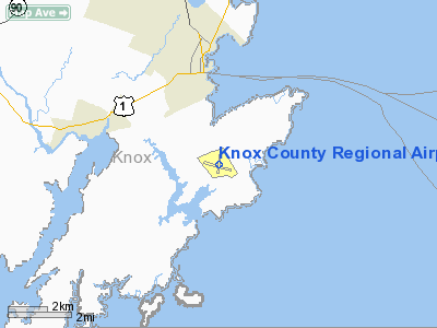
Rockland, Maine |
| Elevation AMSL |
56 ft / 17.1 m |
| Coordinates |
44°03′36″N 69°05′57″W / 44.06°N 69.09917°W / 44.06; -69.09917Coordinates: 44°03′36″N 69°05′57″W / 44.06°N 69.09917°W / 44.06; -69.09917 |
| Runways |
| Direction |
Length |
Surface |
| ft |
m |
| 13/31 |
5,007 |
1,526 |
Asphalt |
| 3/21 |
3,900 |
1,189 |
Asphalt |
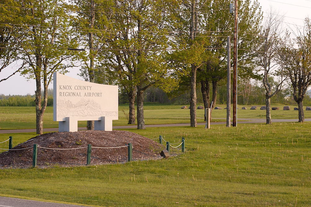
Approaching the runway for landing over Ash Point road Knox County Regional Airport (IATA: RKD, ICAO: KRKD) is a public airport located the town of Owls Head, three miles (5 km) south of the central business district (CBD) of the city of Rockland, in Knox County, Maine, USA. The airport covers 538 acres (218 ha) and has two runways.
Knox County Regional Airport serves the residents of midcoast Maine with commercial and charter aviation services. It is also a major hub of freight and mail service to Maine's island communities including Matinicus, North Haven and Vinalhaven.
During the summer months, the airport is one of Maine's busiest, with significant private jet operations bringing visitors to the numerous summer colonies in the Penobscot Bay region. The influx in traffic in recent years prompted the implementation of a voluntary night curfew on arrivals and departures between 10:30 p.m. and 6:00 a.m.
Owls Head Transportation Museum is also situated at the airport on an older (abandoned) third runway. It has a museum of antique autos, aircraft, and engines. During the summer special event gatherings are held for enthusists.
MBNA, the American credit card corporation that has substantial business operations in the region, owns a large hangar on the airport property. After its purchase by Bank of America, MBNA has scaled back its Knox County presence though. History
The airport was built during World War II and was known as "Ash Point Naval Air Station." With the familiar triangle of runways (the third runway was discontinued in the 1970s) it was one of a string of military airports along the Maine coast.
After the war, it was operated by the City of Rockland until 1968. It was then turned over to Knox County and renamed Knox County Regional Airport. Since that time, the airport has been developed, the runways expanded, and an Instrument Landing System (ILS) was installed.
Airlines and destinations
Scheduled airline service is subsidized by the Essential Air Service program.
| Airlines |
Destinations |
| Cape Air |
Boston |
Charter
- Penobscot Island Air (Charter and freight to Criehaven, Islesboro, Matinicus, North Haven, Swans Island and Vinalhaven.)
The above content comes from Wikipedia and is published under free licenses – click here to read more.
Location & QuickFacts
| FAA Information Effective: | 2008-09-25 |
| Airport Identifier: | RKD |
| Airport Status: | Operational |
| Longitude/Latitude: | 069-05-57.2290W/44-03-36.4000N
-69.099230/44.060111 (Estimated) |
| Elevation: | 56 ft / 17.07 m (Surveyed) |
| Land: | 538 acres |
| From nearest city: | 3 nautical miles S of Rockland, ME |
| Location: | Knox County, ME |
| Magnetic Variation: | 18W (2000) |
Owner & Manager
| Ownership: | Publicly owned |
| Owner: | Knox County |
| Address: | 62 Union St
Rockland, ME 04841 |
| Phone number: | 207-594-0420 |
| Manager: | Jeff Northgraves |
| Address: | 5 Airport Road
Owls Head, ME 04854 |
| Phone number: | 207-594-4131 |
Airport Operations and Facilities
| Airport Use: | Open to public |
| Wind indicator: | Yes |
| Segmented Circle: | Yes |
| Control Tower: | No |
| Lighting Schedule: | DUSK-DAWN
ACTVT MIRL RY 03/21; HIRL RY 13/31; MALSR RY 13 & PAPI RYS 03, 13 & 31; REIL RYS 03 & 31 - CTAF. |
| Beacon Color: | Clear-Green (lighted land airport) |
| Landing fee charge: | No |
| Sectional chart: | Montreal |
| Region: | ANE - New England |
| Boundary ARTCC: | ZBW - Boston |
| Tie-in FSS: | BGR - Bangor |
| FSS on Airport: | No |
| FSS Toll Free: | 1-800-WX-BRIEF |
| NOTAMs Facility: | RKD (NOTAM-d service avaliable) |
| Certification type/date: | III A S 08/20 |
| Federal Agreements: | NGPRY3 |
Airport Communications
| CTAF: | 123.050 |
| Unicom: | 123.050 |
Airport Services
| Fuel available: | 100LLA |
| Airframe Repair: | MAJOR |
| Power Plant Repair: | MAJOR |
| Bottled Oxygen: | NONE |
| Bulk Oxygen: | NONE |
Runway Information
Runway 03/21
| Dimension: | 3900 x 100 ft / 1188.7 x 30.5 m |
| Surface: | ASPH, Good Condition |
| Weight Limit: | Single wheel: 65000 lbs.
Dual wheel: 80000 lbs. |
| Edge Lights: | Medium |
| |
Runway 03 |
Runway 21 |
| Longitude: | 069-06-02.3800W | 069-05-49.9700W |
| Latitude: | 44-03-22.5500N | 44-04-00.0100N |
| Elevation: | 50.00 ft | 55.00 ft |
| Alignment: | 13 | 127 |
| ILS Type: | LOC/DME
| |
| Traffic Pattern: | Left | Left |
| Markings: | Non-precision instrument, Good Condition | Non-precision instrument, Good Condition |
| Crossing Height: | 34.00 ft | 0.00 ft |
| VASI: | 4-light PAPI on left side | |
| Visual Glide Angle: | 3.00° | 0.00° |
| Runway End Identifier: | Yes | |
| Centerline Lights: | No | No |
| Touchdown Lights: | No | No |
| Obstruction: | 50 ft trees, 1200.0 ft from runway, 20:1 slope to clear | 45 ft trees, 1000.0 ft from runway, 100 ft right of centerline, 18:1 slope to clear |
|
Runway 13/31
| Dimension: | 5007 x 100 ft / 1526.1 x 30.5 m |
| Surface: | ASPH, Good Condition |
| Weight Limit: | Single wheel: 65000 lbs.
Dual wheel: 80000 lbs. |
| Edge Lights: | High |
| |
Runway 13 |
Runway 31 |
| Longitude: | 069-06-30.1430W | 069-05-26.0940W |
| Latitude: | 44-03-41.4790N | 44-03-23.8150N |
| Elevation: | 45.00 ft | 54.00 ft |
| Alignment: | 111 | 127 |
| ILS Type: | ILS/DME
| |
| Traffic Pattern: | Left | Left |
| Markings: | Precision instrument, Good Condition | Precision instrument, Good Condition |
| Crossing Height: | 51.00 ft | 50.00 ft |
| VASI: | 4-light PAPI on right side | 4-light PAPI on left side |
| Visual Glide Angle: | 3.00° | 3.00° |
| Approach lights: | MALSR | |
| Runway End Identifier: | No | Yes |
| Centerline Lights: | No | No |
| Touchdown Lights: | No | No |
| Obstruction: | 83 ft trees, 3022.0 ft from runway, 34:1 slope to clear | 40 ft trees, 1000.0 ft from runway, 20:1 slope to clear |
|
Radio Navigation Aids
| ID |
Type |
Name |
Ch |
Freq |
Var |
Dist |
| SUH | NDB | Sprucehead | | 356.00 | 18W | 0.6 nm |
| BST | NDB | Belfast | | 278.00 | 18W | 21.4 nm |
| ISS | NDB | Wiscasset | | 407.00 | 18W | 23.8 nm |
| RL | NDB | Bracy | | 399.00 | 18W | 36.4 nm |
| BUP | NDB | Burnham | | 348.00 | 18W | 39.9 nm |
| BH | NDB | Surry | | 330.00 | 19W | 44.6 nm |
| NHZ | TACAN | Brunswick | 099X | | 17W | 37.3 nm |
| AUG | VOR/DME | Augusta | 051X | 111.40 | 18W | 33.9 nm |
| BGR | VORTAC | Bangor | 095X | 114.80 | 19W | 48.0 nm |
| BGR | VOT | Bangor | | 111.00 | | 46.4 nm |
Remarks
- DEER & SEAGULLS ON & INVOF ARPT.
- VOLUNTARY NIGHT CUFREW IN EFFECT 2230-0600.
- NOISE ABATEMENT PROCEDURES IN EFFECT; CALL 207-596-0617.
- EXISTED PRIOR TO 1959.
Images and information placed above are from
http://www.airport-data.com/airport/RKD/
We thank them for the data!
| General Info
|
| Country |
United States
|
| State |
MAINE
|
| FAA ID |
RKD
|
| Latitude |
44-03-36.300N
|
| Longitude |
069-05-57.300W
|
| Elevation |
55 feet
|
| Near City |
ROCKLAND
|
We don't guarantee the information is fresh and accurate. The data may
be wrong or outdated.
For more up-to-date information please refer to other sources.
|
|