 |
|
Greenville Municipal Airport |
| Greenville Municipal Airport |
| IATA: none – ICAO: none – FAA LID: 3B1 |
| Summary |
| Airport type |
Public |
| Owner |
Town of Greenville |
| Serves |
Greenville, Maine |
| Elevation AMSL |
1,401 ft / 427 m |
| Coordinates |
45°27′47″N 069°33′06″W / 45.46306°N 69.55167°W / 45.46306; -69.55167 |
| Runways |
| Direction |
Length |
Surface |
| ft |
m |
| 14/32 |
3,999 |
1,219 |
Asphalt |
| 3/21 |
3,000 |
914 |
Asphalt |
| Statistics (2006) |
| Aircraft operations |
5,800 |
| Source: Federal Aviation Administration |
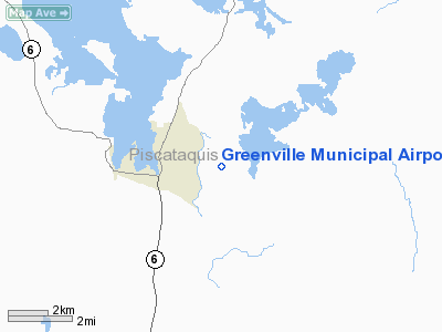
Greenville Municipal Airport (FAA LID: 3B1) is a public airport located two miles (3 km) east of the central business district of Greenville, a town in Piscataquis County, Maine, United States. It is owned by the Town of Greenville.
Facilities and aircraft
Greenville Municipal Airport covers an area of 241 acres (98 ha) which contains two asphalt paved runways: 14/32 measuring 3,999 x 75 ft (1,219 x 23 m) and 3/21 measuring 3,000 x 75 ft (914 x 23 m). For the 12-month period ending August 24, 2006, the airport had 5,800 general aviation aircraft operations, an average of 15 per day.
The above content comes from Wikipedia and is published under free licenses – click here to read more.
Location & QuickFacts
| FAA Information Effective: | 2008-09-25 |
| Airport Identifier: | 3B1 |
| Airport Status: | Operational |
| Longitude/Latitude: | 069-33-05.8000W/45-27-46.9000N
-69.551611/45.463028 (Estimated) |
| Elevation: | 1401 ft / 427.02 m (Surveyed) |
| Land: | 241 acres |
| From nearest city: | 2 nautical miles E of Greenville, ME |
| Location: | Piscataquis County, ME |
| Magnetic Variation: | 18W (1995) |
Owner & Manager
| Ownership: | Publicly owned |
| Owner: | Town Of Greenville |
| Address: | Town Office Building
Greenville, ME 04441 |
| Phone number: | 207-695-2421 |
| Manager: | John Simko |
| Address: | Town Office Bldg
Greenville, ME 04441 |
| Phone number: | 207-695-2421 |
Airport Operations and Facilities
| Airport Use: | Open to public |
| Wind indicator: | Yes |
| Segmented Circle: | Yes |
| Control Tower: | No |
| Lighting Schedule: | DUSK-DAWN
ACTVT MIRL RY 14/32 - CTAF. |
| Beacon Color: | Clear-Green (lighted land airport) |
| Landing fee charge: | No |
| Sectional chart: | Montreal |
| Region: | ANE - New England |
| Boundary ARTCC: | ZBW - Boston |
| Tie-in FSS: | BGR - Bangor |
| FSS on Airport: | No |
| FSS Toll Free: | 1-800-WX-BRIEF |
| NOTAMs Facility: | BGR (NOTAM-d service avaliable) |
| Federal Agreements: | NGY3 |
Airport Communications
| CTAF: | 122.800 |
| Unicom: | 122.800 |
Airport Services
| Fuel available: | 100LL
FOR FUEL & OTHER SVCS CALL 207-695-2993. 24 HR FUEL CREDIT CARD. |
| Airframe Repair: | MAJOR |
| Power Plant Repair: | MAJOR |
| Bottled Oxygen: | NONE |
| Bulk Oxygen: | NONE |
Runway Information
Runway 03/21
| Dimension: | 3000 x 75 ft / 914.4 x 22.9 m |
| Surface: | ASPH, Fair Condition |
| Weight Limit: | Single wheel: 12500 lbs. |
| |
Runway 03 |
Runway 21 |
| Longitude: | 069-33-13.4700W | 069-33-06.6070W |
| Latitude: | 45-27-34.5330N | 45-28-03.7520N |
| Elevation: | 1374.00 ft | 1396.00 ft |
| Alignment: | 9 | 127 |
| Traffic Pattern: | Left | Left |
| Markings: | Basic, Poor Condition
RY 03/21 MARKINGS BADLY FADED. | Basic, Poor Condition |
| Runway End Identifier: | No | No |
| Centerline Lights: | No | No |
| Touchdown Lights: | No | No |
| Obstruction: | 20 ft trees, 201.0 ft from runway
RWY 03 +1 FT BRUSH 100 FT FM THLD 0B. 34 FOOT TREES, 140 FEET FROM THRESHOLD, 125 FEET RIGHT. | 10 ft trees, 201.0 ft from runway
+6 FT BRUSH 80 FT FM THLD 0B. |
|
Runway 14/32
| Dimension: | 3999 x 75 ft / 1218.9 x 22.9 m |
| Surface: | ASPH, Good Condition |
| Weight Limit: | Single wheel: 12500 lbs. |
| Edge Lights: | Medium |
| |
Runway 14 |
Runway 32 |
| Longitude: | 069-33-27.4970W | 069-32-37.6610W |
| Latitude: | 45-27-54.2360N | 45-27-36.1020N |
| Elevation: | 1379.00 ft | 1368.00 ft |
| Alignment: | 117 | 127 |
| Traffic Pattern: | Left | Left |
| Markings: | Non-precision instrument, Good Condition | Basic, Good Condition |
| Crossing Height: | 40.00 ft | 40.00 ft |
| VASI: | 4-light PAPI on right side
PAPI UNUSBL BYD 8 DEGS RIGHT OF CNTRLN. | 4-light PAPI on left side |
| Visual Glide Angle: | 3.00° | 3.10° |
| Runway End Identifier: | Yes | No |
| Centerline Lights: | No | No |
| Touchdown Lights: | No | No |
| Obstruction: | , 50:1 slope to clear | 22 ft trees, 1260.0 ft from runway, 48:1 slope to clear |
|
Radio Navigation Aids
| ID |
Type |
Name |
Ch |
Freq |
Var |
Dist |
| XQA | NDB | Squaw | | 236.00 | 18W | 6.3 nm |
| LRG | NDB | Lincoln | | 216.00 | 19W | 43.3 nm |
| LNT | NDB | Milnot | | 344.00 | 19W | 43.6 nm |
| BUP | NDB | Burnham | | 348.00 | 18W | 46.8 nm |
| OLD | NDB | Old Town | | 272.00 | 20W | 47.6 nm |
| MLT | VOR/DME | Millinocket | 126X | 117.90 | 20W | 44.3 nm |
| BGR | VORTAC | Bangor | 095X | 114.80 | 19W | 47.1 nm |
Remarks
- DEER ON & INVOF ARPT.
- EXISTED PRIOR TO 1959.
Images and information placed above are from
http://www.airport-data.com/airport/3B1/
We thank them for the data!
| General Info
|
| Country |
United States
|
| State |
MAINE
|
| FAA ID |
3B1
|
| Latitude |
45-27-46.900N
|
| Longitude |
069-33-05.800W
|
| Elevation |
1401 feet
|
| Near City |
GREENVILLE
|
We don't guarantee the information is fresh and accurate. The data may
be wrong or outdated.
For more up-to-date information please refer to other sources.
|
|


