 |
|
Eastern Slopes Regional Airport |
Coordinates: 43°59′28″N 070°56′52″W / 43.99111°N 70.94778°W / 43.99111; -70.94778
| Eastern Slopes Regional Airport |
| IATA: FRY – ICAO: KIZG – FAA LID: IZG |
| Summary |
| Airport type |
Public |
| Owner |
Eastern Slopes Regional Airport Authority |
| Serves |
Fryeburg, Maine |
| Elevation AMSL |
454 ft / 138 m |
| Runways |
| Direction |
Length |
Surface |
| ft |
m |
| 14/32 |
4,200 |
1,280 |
Asphalt |
| Statistics (2006) |
| Aircraft operations |
33,350 |
| Source: Federal Aviation Administration |
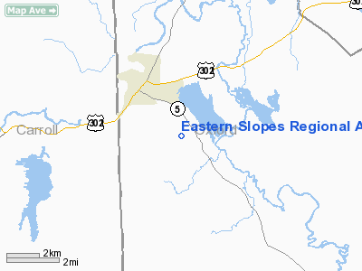
Eastern Slopes Regional Airport (IATA: FRY, ICAO: KIZG, FAA LID: IZG), also known as Eastern Slopes State Airport, is a public airport located three miles (5 km) southeast of the central business district of Fryeburg, a town in Oxford County, Maine, United States. It is owned by the Eastern Slopes Regional Airport Authority. The airport is accessible from ME-5 in Fryeburg and Brownfield, Maine. It is very close to Conway, New Hampshire.
Although most U.S. airports use the same three-letter location identifier for the FAA and IATA, Eastern Slopes Regional Airport is assigned IZG by the FAA and FRY by the IATA. History
The airport was built to replace the North Conway airport (closed in 1988 and now Settler's Green Outlet Village).
Until 2004, the airport served very little purpose except to Dearborn Precision Tubular Products, which used it as a cargo stop. In 2004, Eastern Slopes Aviation began to try and secure funding for development at the airport, including the construction of a terminal and the establishment of commuter service from the airport to Portland, Maine, slated to begin in spring 2006. The airport handled 12,605 passengers in 2004.
Facilities and aircraft
Eastern Slopes Regional Airport covers an area of 533 acres (216 ha) which contains one runway designated 14/32 with a 4,200 x 75 ft (1,280 x 23 m) asphalt surface. For the 12-month period ending August 26, 2006, the airport had 33,350 aircraft operations, an average of 91 per day: 99% general aviation (33,000), 1% air taxi and <1% military.
Airlines (passenger and cargo)
- Eastern Slopes Aviation (Boston's Logan, Portland)
- Linear Air (Air Charter Boston Hanscom, Bedford)
Historical Service
- 1952-present: Eastern Slopes Aviation
- 2006: Saco Airlines
The above content comes from Wikipedia and is published under free licenses – click here to read more.
Location & QuickFacts
| FAA Information Effective: | 2008-09-25 |
| Airport Identifier: | IZG |
| Airport Status: | Operational |
| Longitude/Latitude: | 070-56-52.3480W/43-59-28.1210N
-70.947874/43.991145 (Estimated) |
| Elevation: | 454 ft / 138.38 m (Surveyed) |
| Land: | 533 acres |
| From nearest city: | 3 nautical miles SE of Fryeburg, ME |
| Location: | Oxford County, ME |
| Magnetic Variation: | 17W (1995) |
Owner & Manager
| Ownership: | Publicly owned |
| Owner: | Eastern Slope Regional Apt Auth |
| Address: | Box 334
Fryeburg, ME 04037 |
| Phone number: | 207-935-2050 |
| Manager: | Joseph Solari, Chairman Arpt Auth |
| Address: | Eastern Slope Arpt,
Fryeburg, ME 04037 |
| Phone number: | 207-935-2050 |
Airport Operations and Facilities
| Airport Use: | Open to public |
| Wind indicator: | Yes |
| Segmented Circle: | Yes |
| Control Tower: | No |
| Lighting Schedule: | DUSK-DAWN
ACTVT MIRL RY 14/32 - CTAF. |
| Beacon Color: | Clear-Green (lighted land airport) |
| Landing fee charge: | No |
| Sectional chart: | New York |
| Region: | ANE - New England |
| Boundary ARTCC: | ZBW - Boston |
| Tie-in FSS: | BGR - Bangor |
| FSS on Airport: | No |
| FSS Toll Free: | 1-800-WX-BRIEF |
| NOTAMs Facility: | IZG (NOTAM-d service avaliable) |
| Federal Agreements: | NGY |
Airport Communications
| CTAF: | 122.800 |
| Unicom: | 122.800 |
Airport Services
| Fuel available: | 100LL
24 HR CREDIT CARD FUEL. |
| Airframe Repair: | MAJOR |
| Power Plant Repair: | MAJOR |
| Bottled Oxygen: | NONE |
| Bulk Oxygen: | NONE |
Runway Information
Runway 14/32
| Dimension: | 4200 x 75 ft / 1280.2 x 22.9 m |
| Surface: | ASPH, Good Condition |
| Weight Limit: | Single wheel: 30000 lbs. |
| Edge Lights: | Medium |
| |
Runway 14 |
Runway 32 |
| Longitude: | 070-57-15.4490W | 070-56-29.2460W |
| Latitude: | 43-59-40.4470N | 43-59-15.7960N |
| Elevation: | 454.00 ft | 420.00 ft |
| Alignment: | 126 | 127 |
| Traffic Pattern: | Left | Left |
| Markings: | Basic, Fair Condition | Non-precision instrument, Fair Condition |
| VASI: | | 2-box on left side |
| Runway End Identifier: | | Yes |
| Obstruction: | 20 ft trees, 410.0 ft from runway, 125 ft right of centerline, 11:1 slope to clear | 12 ft trees, 210.0 ft from runway, 200 ft left of centerline
TREES +12 FT 120 FT FM RY END; 200 FT R & L. |
|
Radio Navigation Aids
| ID |
Type |
Name |
Ch |
Freq |
Var |
Dist |
| SZO | FAN MARKER | Grinn | | | 17W | 3.5 nm |
| LCI | FAN MARKER | Laconia | | | | 33.3 nm |
| HIE | FAN MARKER | Witey | | | 17W | 34.9 nm |
| PH | MARINE NDB | Portland Lhb-p | | 301.00 | 17W | 46.5 nm |
| SZO | NDB | Sebago | | 227.00 | 17W | 8.9 nm |
| HXK | NDB | Hornebrook | | 281.00 | 17W | 36.6 nm |
| LC | NDB | Blnap | | 328.00 | 16W | 37.4 nm |
| GMA | NDB | Mahn | | 386.00 | 17W | 38.9 nm |
| ESG | NDB | Rollins | | 260.00 | 16W | 46.6 nm |
| NHZ | TACAN | Brunswick | 099X | | 17W | 45.0 nm |
| BML | VOR/DME | Berlin | 041X | 110.40 | 17W | 39.9 nm |
| ENE | VORTAC | Kennebunk | 118X | 117.10 | 17W | 37.0 nm |
| PWM | VOT | Portland Intl Jetport | | 111.00 | | 34.5 nm |
Remarks
- OBSTN LGTD HILLS IN APCH TO RWY 4500' N, 10000' NW & 7000' SW.
- BIRDS & DEER ON & INVOF ARPT.
Images and information placed above are from
http://www.airport-data.com/airport/IZG/
We thank them for the data!
| General Info
|
| Country |
United States
|
| State |
MAINE
|
| FAA ID |
IZG
|
| Latitude |
43-59-28.121N
|
| Longitude |
070-56-52.348W
|
| Elevation |
454 feet
|
| Near City |
FRYEBURG
|
We don't guarantee the information is fresh and accurate. The data may
be wrong or outdated.
For more up-to-date information please refer to other sources.
|
|


