 |
|
| Dexter Regional Airport |
| IATA: none – ICAO: none – FAA LID: 1B0 |
| Summary |
| Airport type |
Public |
| Owner |
Town of Dexter |
| Serves |
Dexter, Maine |
| Elevation AMSL |
533 ft / 162 m |
| Coordinates |
45°00′14.9″N 069°14′13.3″W / 45.004139°N 69.237028°W / 45.004139; -69.237028 |
| Runways |
| Direction |
Length |
Surface |
| ft |
m |
| 16/34 |
3,009 |
917 |
Asphalt |
| Statistics (2008) |
| Aircraft operations |
6,963 |
| Based aircraft |
35 |
| Source: Federal Aviation Administration |
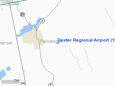
Dexter Regional Airport is a public use airport in Penobscot County, Maine, United States. It is owned by the Town of Dexter and is located three nautical miles (5.56 km) east of the central business district.
Facilities and aircraft
Dexter Regional Airport covers an area of 311 acres (126 ha) at an elevation of 533 feet (162 m) above mean sea level. It has one runway designated 16/34 with an asphalt surface measuring 3,009 by 80 feet (917 x 24 m).
For the 12-month period ending August 10, 2008, the airport had 6,963 aircraft operations, an average of 19 per day: 100% general aviation with a few ultralights. At that time there were 35 aircraft based at this airport: 86% single-engine, 9% ultralights, 3% multi-engine, and 3% helicopters.
The above content comes from Wikipedia and is published under free licenses – click here to read more.
Location & QuickFacts
| FAA Information Effective: | 2008-09-25 |
| Airport Identifier: | 1B0 |
| Airport Status: | Operational |
| Longitude/Latitude: | 069-14-13.3000W/45-00-14.9000N
-69.237028/45.004139 (Estimated) |
| Elevation: | 533 ft / 162.46 m (Surveyed) |
| Land: | 311 acres |
| From nearest city: | 3 nautical miles E of Dexter, ME |
| Location: | Penobscot County, ME |
| Magnetic Variation: | 18W (1995) |
Owner & Manager
| Ownership: | Publicly owned |
| Owner: | Town Of Dexter |
| Address: | Town Office Bldg, 23 Main
Dexter, ME 04930 |
| Phone number: | 207-924-7351 |
| Manager: | Roger Nelson |
| Address: | 599 Spring St
Dexter, ME 04930 |
| Phone number: | 207-924-7102 |
Airport Operations and Facilities
| Airport Use: | Open to public |
| Wind indicator: | Yes |
| Segmented Circle: | No |
| Control Tower: | No |
| Lighting Schedule: | DUSK-DAWN
ACTVT LIRL RY 16/34 - 122.8. |
| Beacon Color: | Clear-Green (lighted land airport) |
| Landing fee charge: | No |
| Sectional chart: | Montreal |
| Region: | ANE - New England |
| Boundary ARTCC: | ZBW - Boston |
| Tie-in FSS: | BGR - Bangor |
| FSS on Airport: | No |
| FSS Toll Free: | 1-800-WX-BRIEF |
| NOTAMs Facility: | BGR (NOTAM-d service avaliable) |
| Federal Agreements: | NGY3 |
Airport Communications
| CTAF: | 122.800 |
| Unicom: | 122.800 |
Airport Services
| Airframe Repair: | NONE |
| Power Plant Repair: | NONE |
| Bottled Oxygen: | NONE |
| Bulk Oxygen: | NONE |
Runway Information
Runway 16/34
| Dimension: | 3009 x 80 ft / 917.1 x 24.4 m |
| Surface: | ASPH, Fair Condition |
| Weight Limit: | Single wheel: 30000 lbs. |
| Edge Lights: | Low |
| |
Runway 16 |
Runway 34 |
| Longitude: | 069-14-25.2577W | 069-13-57.9350W |
| Latitude: | 45-00-27.5991N | 45-00-05.0888N |
| Elevation: | 516.00 ft | 518.00 ft |
| Alignment: | 127 | 127 |
| Traffic Pattern: | Left | Left |
| Markings: | Basic, Good Condition | Non-precision instrument, Good Condition |
| Runway End Identifier: | No | No |
| Centerline Lights: | No | No |
| Touchdown Lights: | No | No |
| Obstruction: | 9 ft tree, 363.0 ft from runway, 18:1 slope to clear | 11 ft pole, 254.0 ft from runway, 32 ft right of centerline, 4:1 slope to clear
RY 34 +10 FT POLE, 140 FT RY END, 126 FT L; +8 FT CHIMNEY, 193 FT RY END 146 FT L. |
|
Radio Navigation Aids
| ID |
Type |
Name |
Ch |
Freq |
Var |
Dist |
| BUP | NDB | Burnham | | 348.00 | 18W | 19.1 nm |
| OLD | NDB | Old Town | | 272.00 | 20W | 25.7 nm |
| XQA | NDB | Squaw | | 236.00 | 18W | 36.2 nm |
| LRG | NDB | Lincoln | | 216.00 | 19W | 36.4 nm |
| BST | NDB | Belfast | | 278.00 | 18W | 36.9 nm |
| RL | NDB | Bracy | | 399.00 | 18W | 39.0 nm |
| LNT | NDB | Milnot | | 344.00 | 19W | 48.4 nm |
| BH | NDB | Surry | | 330.00 | 19W | 48.6 nm |
| MLT | VOR/DME | Millinocket | 126X | 117.90 | 20W | 46.4 nm |
| AUG | VOR/DME | Augusta | 051X | 111.40 | 18W | 47.6 nm |
| BGR | VORTAC | Bangor | 095X | 114.80 | 19W | 18.3 nm |
| BGR | VOT | Bangor | | 111.00 | | 21.8 nm |
Remarks
- RY 34 30 FT DROPOFF 30 FT FM EOR.
- RY 16 30 FT DROPOFF 145 FT FM EOR.
- EXISTED PRIOR TO 1959.
Images and information placed above are from
http://www.airport-data.com/airport/1B0/
We thank them for the data!
| General Info
|
| Country |
United States
|
| State |
MAINE
|
| FAA ID |
1B0
|
| Latitude |
45-00-30.220N
|
| Longitude |
069-14-23.162W
|
| Elevation |
533 feet
|
| Near City |
DEXTER
|
We don't guarantee the information is fresh and accurate. The data may
be wrong or outdated.
For more up-to-date information please refer to other sources.
|
|


