|
|
Dewitt Fld Old Town Municipal Airport |
Old Town Municipal Airport
Dewitt Field |
| IATA: OLD – ICAO: KOLD – FAA LID: OLD |
| Summary |
| Airport type |
Public |
| Owner |
City of Old Town |
| Serves |
Old Town, Maine |
| Elevation AMSL |
126 ft / 38 m |
| Coordinates |
44°57′09″N 068°40′28″W / 44.9525°N 68.67444°W / 44.9525; -68.67444 |
| Runways |
| Direction |
Length |
Surface |
| ft |
m |
| 4/22 |
3,199 |
975 |
Asphalt |
| 12/30 |
3,999 |
1,219 |
Asphalt |
| 17W/35W |
8,400 |
2,560 |
Water |
| Statistics (2006) |
| Aircraft operations |
47,160 |
| Based aircraft |
51 |
| Source: Federal Aviation Administration |
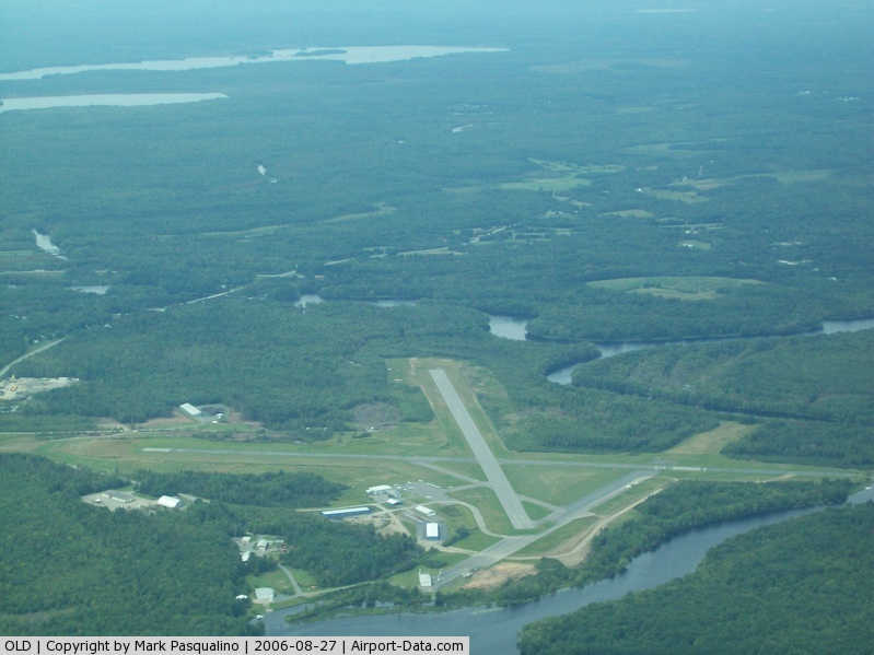
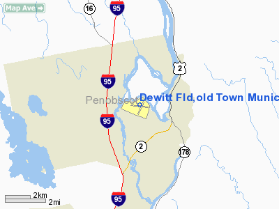
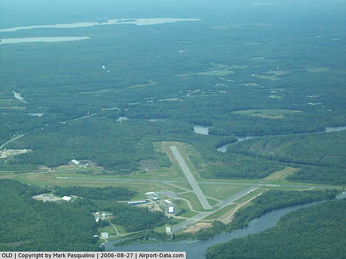
Old Town Municipal Airport and Seaplane Base (IATA: OLD, ICAO: KOLD, FAA LID: OLD), also known as Dewitt Field, is a public use airport located two nautical miles (4 km) northwest of the central business district of Old Town, in Penobscot County, Maine, United States. It is owned by the City of Old Town. The seaplane base is located on the Penobscot River.
Facilities and aircraft
Dewitt Field covers an area of 360 acres (146 ha) at an elevation of 126 feet (38 m) above mean sea level. It has two asphalt paved runways: 12/30 measuring 3,999 x 100 ft (1,219 x 30 m) and 4/22 measuring: 3,199 x 75 ft (975 x 23 m). It also has one seaplane landing area (17W/35W) measuring 8,400 x 100 ft (2,560 x 30 m).
For the 12-month period ending July 31, 2006, the airport had 47,160 aircraft operations, an average of 129 per day: 99% general aviation and 1% military. At that time there were 51 aircraft based at this airport: 80% single-engine, 8% multi-engine, 10% helicopter and 2% ultralight.
The above content comes from Wikipedia and is published under free licenses – click here to read more.
|
 |
(Click on the photo to enlarge) |
Location & QuickFacts
| FAA Information Effective: | 2008-09-25 |
| Airport Identifier: | OLD |
| Airport Status: | Operational |
| Longitude/Latitude: | 068-40-27.6000W/44-57-09.0000N
-68.674333/44.952500 (Estimated) |
| Elevation: | 126 ft / 38.40 m (Surveyed)
RY 17W/35W ELEVATION IS 102 FT (ESTIMATED). |
| Land: | 360 acres |
| From nearest city: | 2 nautical miles NW of Old Town, ME |
| Location: | Penobscot County, ME |
| Magnetic Variation: | 19W (1995) |
Owner & Manager
| Ownership: | Publicly owned |
| Owner: | City Of Old Town |
| Address: | City Hall
Old Town, ME 04468 |
| Phone number: | 207-827-3968 |
| Manager: | David Wight |
| Address: | Old Town Muni Arpt, P.o. Box 558
Old Town, ME 04468 |
| Phone number: | 207-827-3974 |
Airport Operations and Facilities
| Airport Use: | Open to public |
| Wind indicator: | Yes |
| Segmented Circle: | No |
| Control Tower: | No |
| Lighting Schedule: | DUSK-DAWN
ACTVT MIRL RY 04/22 & RY 12/30 - CTAF. |
| Beacon Color: | Clear-Green (lighted land airport)
ROTG BCN OTS INDEFLY. |
| Landing fee charge: | No |
| Sectional chart: | Halifax |
| Region: | ANE - New England |
| Boundary ARTCC: | ZBW - Boston |
| Tie-in FSS: | BGR - Bangor |
| FSS on Airport: | No |
| FSS Toll Free: | 1-800-WX-BRIEF |
| NOTAMs Facility: | BGR (NOTAM-d service avaliable) |
| Federal Agreements: | NGY3 |
Airport Communications
| CTAF: | 122.800 |
| Unicom: | 122.800 |
Airport Services
| Fuel available: | 100LLA |
| Airframe Repair: | MAJOR |
| Power Plant Repair: | MAJOR |
| Bottled Oxygen: | LOW |
| Bulk Oxygen: | NONE |
Runway Information
Runway 04/22
| Dimension: | 3199 x 75 ft / 975.1 x 22.9 m |
| Surface: | ASPH, Good Condition |
| Weight Limit: | Single wheel: 37000 lbs.
Dual wheel: 45000 lbs. |
| Edge Lights: | Medium |
| |
Runway 04 |
Runway 22 |
| Longitude: | 068-40-32.4038W | 068-40-15.7474W |
| Latitude: | 44-56-52.0093N | 44-57-21.2953N |
| Elevation: | 126.00 ft | 119.00 ft |
| Alignment: | 22 | 127 |
| Traffic Pattern: | Left | Left |
| Markings: | Non-precision instrument, Fair Condition | Non-precision instrument, Fair Condition |
| Crossing Height: | 0.00 ft | 52.00 ft |
| VASI: | | 4-box on left side |
| Visual Glide Angle: | 0.00° | 3.50° |
| Runway End Identifier: | Yes | No |
| Centerline Lights: | No | No |
| Touchdown Lights: | No | No |
|
Runway 12/30
| Dimension: | 3999 x 100 ft / 1218.9 x 30.5 m |
| Surface: | ASPH, Good Condition |
| Weight Limit: | Single wheel: 30000 lbs. |
| Edge Lights: | Medium |
| |
Runway 12 |
Runway 30 |
| Longitude: | 068-40-57.9606W | 068-40-02.7203W |
| Latitude: | 44-57-13.1656N | 44-57-08.6759N |
| Elevation: | 124.00 ft | 119.00 ft |
| Alignment: | 97 | 127 |
| Traffic Pattern: | Left | Left |
| Markings: | Non-precision instrument, Poor Condition
MKGS FADED & PAINT PEELING. | Non-precision instrument, Poor Condition
MKGS FADED & PAINT PEELING. |
| Crossing Height: | 0.00 ft | 45.00 ft |
| VASI: | | 4-light PAPI on left side |
| Visual Glide Angle: | 0.00° | 3.50° |
| Runway End Identifier: | No | No |
| Centerline Lights: | No | No |
| Touchdown Lights: | No | No |
| Obstruction: | 25 ft trees, 550.0 ft from runway, 50 ft left of centerline, 14:1 slope to clear | 37 ft trees, 875.0 ft from runway, 50 ft right of centerline, 18:1 slope to clear |
|
Runway 17W/35W
| Dimension: | 8400 x 100 ft / 2560.3 x 30.5 m |
| Surface: | WATER, |
| |
Runway 17W |
Runway 35W |
| Traffic Pattern: | Left | Left |
| Runway End Identifier: | No | No |
| Centerline Lights: | No | No |
| Touchdown Lights: | No | No |
|
Radio Navigation Aids
| ID |
Type |
Name |
Ch |
Freq |
Var |
Dist |
| OLD | NDB | Old Town | | 272.00 | 20W | 3.7 nm |
| LRG | NDB | Lincoln | | 216.00 | 19W | 25.0 nm |
| BH | NDB | Surry | | 330.00 | 19W | 29.4 nm |
| BUP | NDB | Burnham | | 348.00 | 18W | 32.9 nm |
| BST | NDB | Belfast | | 278.00 | 18W | 35.6 nm |
| LNT | NDB | Milnot | | 344.00 | 19W | 42.2 nm |
| MLT | VOR/DME | Millinocket | 126X | 117.90 | 20W | 38.7 nm |
| PNN | VOR/DME | Princeton | 090X | 114.30 | 21W | 47.0 nm |
| BGR | VORTAC | Bangor | 095X | 114.80 | 19W | 10.8 nm |
| BGR | VOT | Bangor | | 111.00 | | 10.6 nm |
Remarks
Images and information placed above are from
http://www.airport-data.com/airport/OLD/
We thank them for the data!
| General Info
|
| Country |
United States
|
| State |
MAINE
|
| FAA ID |
OLD
|
| Latitude |
44-57-09.000N
|
| Longitude |
068-40-27.600W
|
| Elevation |
126 feet
|
| Near City |
OLD TOWN
|
We don't guarantee the information is fresh and accurate. The data may
be wrong or outdated.
For more up-to-date information please refer to other sources.
|
|