 |
|
Biddeford Municipal Airport |
| Biddeford Municipal Airport |
| IATA: none – ICAO: none – FAA LID: B19 |
| Summary |
| Airport type |
Public |
| Owner |
City of Biddeford |
| Serves |
Biddeford, Maine |
| Elevation AMSL |
157 ft / 48 m |
| Coordinates |
43°27′50.8″N 070°28′20.6″W / 43.464111°N 70.472389°W / 43.464111; -70.472389 |
| Runways |
| Direction |
Length |
Surface |
| ft |
m |
| 06/24 |
3,000 |
914 |
Asphalt |
| Statistics (2008) |
| Aircraft operations |
23,150 |
| Based aircraft |
48 |
| Source: Federal Aviation Administration |
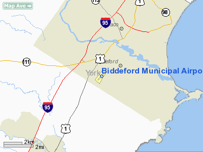
Biddeford Municipal Airport (FAA LID: B19) is a public use airport in York County, Maine, United States. It is owned by the City of Biddeford and is located two nautical miles (3.70 km) south of the central business district.
Facilities and aircraft
Biddeford Municipal Airport covers an area of 126 acres (51 ha) at an elevation of 157 feet (48 m) above mean sea level. It has one runway designated 06/24 with an asphalt surface measuring 3,000 by 75 feet (914 x 23 m).
For the 12-month period ending August 19, 2008, the airport had 23,150 aircraft operations, an average of 63 per day: 100% general aviation with a few military. At that time there were 48 aircraft based at this airport: 96% single-engine and 4% multi-engine.
The above content comes from Wikipedia and is published under free licenses – click here to read more.
Location & QuickFacts
| FAA Information Effective: | 2008-09-25 |
| Airport Identifier: | B19 |
| Airport Status: | Operational |
| Longitude/Latitude: | 070-28-20.6000W/43-27-50.8000N
-70.472389/43.464111 (Estimated) |
| Elevation: | 157 ft / 47.85 m (Surveyed) |
| Land: | 126 acres |
| From nearest city: | 2 nautical miles S of Biddeford, ME |
| Location: | York County, ME |
| Magnetic Variation: | 17W (2000) |
Owner & Manager
| Ownership: | Publicly owned |
| Owner: | City Of Biddeford |
| Address: | Box 586 205 Main St.
Biddeford, ME 04005 |
| Phone number: | 207-283-0181 |
| Manager: | Tom Bryand |
| Address: | 17 Landry St
Biddeford, ME 04005 |
| Phone number: | 207-284-2200 |
Airport Operations and Facilities
| Airport Use: | Open to public |
| Wind indicator: | Yes |
| Segmented Circle: | No |
| Control Tower: | No |
| Lighting Schedule: | DUSK-DAWN
ACTVT MIRL RY 06/24 & REIL RY 06 - CTAF; VASI RY 06 OPERATE 24 HRS. |
| Beacon Color: | Clear-Green (lighted land airport) |
| Landing fee charge: | No |
| Sectional chart: | New York |
| Region: | ANE - New England |
| Traffic Pattern Alt: | 838 ft |
| Boundary ARTCC: | ZBW - Boston |
| Tie-in FSS: | BGR - Bangor |
| FSS on Airport: | No |
| FSS Toll Free: | 1-800-WX-BRIEF |
| NOTAMs Facility: | BGR (NOTAM-d service avaliable) |
| Federal Agreements: | NGY |
Airport Communications
| CTAF: | 123.000 |
| Unicom: | 123.000 |
Airport Services
| Fuel available: | 100LL |
| Airframe Repair: | MAJOR |
| Power Plant Repair: | MAJOR |
| Bottled Oxygen: | NONE |
| Bulk Oxygen: | NONE |
Runway Information
Runway 06/24
| Dimension: | 3000 x 75 ft / 914.4 x 22.9 m |
| Surface: | ASPH, Fair Condition |
| Weight Limit: | Single wheel: 25000 lbs. |
| Edge Lights: | Medium |
| |
Runway 06 |
Runway 24 |
| Longitude: | 070-28-33.9100W | 070-28-07.3560W |
| Latitude: | 43-27-39.5900N | 43-28-02.0310N |
| Elevation: | 146.00 ft | 155.00 ft |
| Alignment: | 41 | 127 |
| Traffic Pattern: | Left | Left |
| Markings: | Basic, Fair Condition | Basic, Fair Condition |
| Crossing Height: | 31.00 ft | 0.00 ft |
| VASI: | 4-box on left side | |
| Visual Glide Angle: | 3.50° | 0.00° |
| Runway End Identifier: | Yes | No |
| Obstruction: | 8 ft brush, 201.0 ft from runway, 140 ft right of centerline
BRUSH +6 FT AT END OF RWY, 140 FT RIGHT | 15 ft tree, 341.0 ft from runway, 52 ft right of centerline, 9:1 slope to clear
BRUSH +3 FT AT END OF RUNWAY, 125 FT RIGHT AND LEFT |
|
Radio Navigation Aids
| ID |
Type |
Name |
Ch |
Freq |
Var |
Dist |
| SZO | FAN MARKER | Grinn | | | 17W | 34.6 nm |
| LCI | FAN MARKER | Laconia | | | | 42.7 nm |
| PH | MARINE NDB | Portland Lhb-p | | 301.00 | 17W | 17.0 nm |
| ESG | NDB | Rollins | | 260.00 | 16W | 21.4 nm |
| SZO | NDB | Sebago | | 227.00 | 17W | 29.7 nm |
| LC | NDB | Blnap | | 328.00 | 16W | 46.6 nm |
| CO | NDB | Epsom | | 216.00 | 16W | 47.6 nm |
| ISS | NDB | Wiscasset | | 407.00 | 18W | 47.7 nm |
| NHZ | TACAN | Brunswick | 099X | | 17W | 34.3 nm |
| PSM | VOR/DME | Pease | 112X | 116.50 | 16W | 27.7 nm |
| ENE | VORTAC | Kennebunk | 118X | 117.10 | 17W | 6.6 nm |
| PWM | VOT | Portland Intl Jetport | | 111.00 | | 12.6 nm |
Remarks
- DEER ON & INVOF ARPT.
- NOISE ABATEMENT IN EFCT 24 HRS; FOR SPECIFICS CTC FBO 877-247-1878.
- EXISTED PRIOR TO 1959.
Images and information placed above are from
http://www.airport-data.com/airport/B19/
We thank them for the data!
| General Info
|
| Country |
United States
|
| State |
MAINE
|
| FAA ID |
B19
|
| Latitude |
43-27-50.800N
|
| Longitude |
070-28-20.600W
|
| Elevation |
157 feet
|
| Near City |
BIDDEFORD
|
We don't guarantee the information is fresh and accurate. The data may
be wrong or outdated.
For more up-to-date information please refer to other sources.
|
|


