 |
|
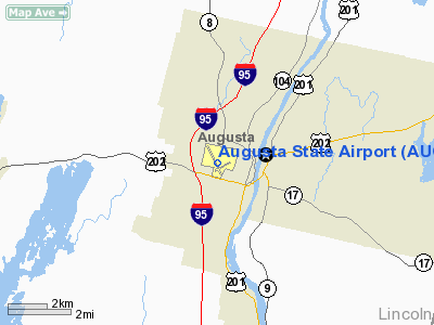
| Augusta State Airport |
| IATA: AUG – ICAO: KAUG – FAA LID: AUG |
| Summary |
| Airport type |
Public |
| Owner |
State of Maine |
| Serves |
Augusta, Maine |
| Elevation AMSL |
352 ft / 107 m |
| Coordinates |
44°19′14″N 069°47′50″W / 44.32056°N 69.79722°W / 44.32056; -69.79722 |
| Website |
www.AugustaAirport.org |
| Runways |
| Direction |
Length |
Surface |
| ft |
m |
| 17/35 |
5,001 |
1,524 |
Asphalt |
| 8/26 |
2,703 |
824 |
Asphalt |
| Statistics (2007) |
| Aircraft operations |
33,800 |
| Based aircraft |
46 |
| Sources: FAA and airport website |
Augusta Airport during or before the Second World War. US Military image Augusta State Airport (IATA: AUG, ICAO: KAUG, FAA LID: AUG) is a public use airport located one nautical mile (2 km) northwest of the central business district of Augusta, a city in Kennebec County, Maine, United States. It is owned by the state of Maine, but managed and operated by the city of Augusta. The airport is mostly used for general aviation, but is served by one commercial airline. Service is subsidized by the Essential Air Service program. Facilities and aircraft
Augusta State Airport covers an area of 350 acres (142 ha) at an elevation of 352 feet (107 m) above mean sea level. It has two asphalt paved runways: 17/35 measuring 5,001 x 150 feet (1,524 x 46 m) and 8/26 measuring 2,703 x 75 feet (824 x 23 m).
For the 12-month period ending June 30, 2007, the airport had 33,800 aircraft operations, an average of 92 per day: 75% general aviation, 16% air taxi and 9% military. At that time there were 46 aircraft based at this airport: 89% single-engine and 11% multi-engine.
Airlines and destinations
| Airlines |
Destinations |
| New England Air Transport |
Frenchville, Portland, Presque Isle [Temporarily Suspended] |
| US Airways Express operated by Colgan Air |
Boston, Bar Harbor |
The above content comes from Wikipedia and is published under free licenses – click here to read more.
Location & QuickFacts
| FAA Information Effective: | 2008-09-25 |
| Airport Identifier: | AUG |
| Airport Status: | Operational |
| Longitude/Latitude: | 069-47-50.3450W/44-19-14.3390N
-69.797318/44.320650 (Estimated) |
| Elevation: | 352 ft / 107.29 m (Surveyed) |
| Land: | 350 acres |
| From nearest city: | 1 nautical miles NW of Augusta, ME |
| Location: | Kennebec County, ME |
| Magnetic Variation: | 18W (1985) |
Owner & Manager
| Ownership: | Publicly owned |
| Owner: | State Of Maine |
| Address: | 16 State House Station
Augusta, ME 04333 |
| Phone number: | 202-624-3250 |
| Manager: | John Guimond |
| Address: | 75 Airport Rd
Augusta, ME 04330 |
| Phone number: | 207-626-2306 |
Airport Operations and Facilities
| Airport Use: | Open to public |
| Wind indicator: | Yes |
| Segmented Circle: | Yes |
| Control Tower: | No |
| Lighting Schedule: | DUSK-DAWN
ACTVT HIRL RY 17/35; MIRL RY 08/26; REIL RY 35; VASI RY 17 & MALSR RY 17 - CTAF. |
| Beacon Color: | Clear-Green (lighted land airport) |
| Landing fee charge: | Yes |
| Sectional chart: | Montreal |
| Region: | ANE - New England |
| Traffic Pattern Alt: | 1048 ft |
| Boundary ARTCC: | ZBW - Boston |
| Tie-in FSS: | BGR - Bangor |
| FSS Toll Free: | 1-800-WX-BRIEF |
| NOTAMs Facility: | AUG (NOTAM-d service avaliable) |
| Certification type/date: | III A S 10/20 |
| Federal Agreements: | NGPY3 |
Airport Communications
| CTAF: | 123.000 |
| Unicom: | 123.000 |
Airport Services
| Fuel available: | 100LLA
FOR FUEL AFTER NORMAL BUSINESS HRS CALL OR 207-622-2507. |
| Airframe Repair: | MAJOR |
| Power Plant Repair: | MAJOR |
| Bottled Oxygen: | NONE |
| Bulk Oxygen: | NONE |
Runway Information
Runway 08/26
| Dimension: | 2703 x 75 ft / 823.9 x 22.9 m |
| Surface: | ASPH, Good Condition |
| Weight Limit: | Single wheel: 30000 lbs. |
| Edge Lights: | Medium |
| |
Runway 08 |
Runway 26 |
| Longitude: | 069-47-53.1969W | 069-47-20.3501W |
| Latitude: | 44-19-02.1314N | 44-19-14.6458N |
| Elevation: | 349.00 ft | 352.00 ft |
| Alignment: | 62 | 127 |
| Traffic Pattern: | Left | Left |
| Markings: | Non-precision instrument, Good Condition | Non-precision instrument, Good Condition |
| Runway End Identifier: | No | No |
| Centerline Lights: | No | No |
| Touchdown Lights: | No | No |
| Obstruction: | 26 ft tree, 272.0 ft from runway, 75 ft left of centerline, 2:1 slope to clear | 6 ft road, 201.0 ft from runway, 131 ft left of centerline
ROAD & FENCE LEFT OF APCH, 0-200 FT FM RY END LGTD. |
|
Runway 17/35
| Dimension: | 5001 x 150 ft / 1524.3 x 45.7 m |
| Surface: | ASPH, Good Condition |
| Surface Treatment: | Porous Friction Course |
| Weight Limit: | Single wheel: 50000 lbs.
Dual wheel: 60000 lbs. |
| Edge Lights: | High |
| |
Runway 17 |
Runway 35 |
| Longitude: | 069-48-13.2375W | 069-47-42.1086W |
| Latitude: | 44-19-39.5634N | 44-18-55.5220N |
| Elevation: | 310.00 ft | 347.00 ft |
| Alignment: | 127 | 127 |
| ILS Type: | ILS
| |
| Traffic Pattern: | Left | Left |
| Markings: | Precision instrument, Good Condition | Precision instrument, Good Condition |
| Crossing Height: | 60.00 ft | 46.00 ft |
| VASI: | 4-box on right side | 4-box on left side |
| Visual Glide Angle: | 3.00° | 3.00° |
| Approach lights: | MALSR | |
| Runway End Identifier: | | Yes |
| Centerline Lights: | No | No |
| Touchdown Lights: | No | No |
| Obstruction: | , 50:1 slope to clear | 15 ft road, 201.0 ft from runway, 400 ft right of centerline
RWY 35, ROAD 240 FT RT, 0-200 FT FROM RWY END |
|
Radio Navigation Aids
| ID |
Type |
Name |
Ch |
Freq |
Var |
Dist |
| PH | MARINE NDB | Portland Lhb-p | | 301.00 | 17W | 49.4 nm |
| RL | NDB | Bracy | | 399.00 | 18W | 8.8 nm |
| ISS | NDB | Wiscasset | | 407.00 | 18W | 21.4 nm |
| BUP | NDB | Burnham | | 348.00 | 18W | 29.5 nm |
| SUH | NDB | Sprucehead | | 356.00 | 18W | 34.0 nm |
| BST | NDB | Belfast | | 278.00 | 18W | 34.2 nm |
| SZO | NDB | Sebago | | 227.00 | 17W | 49.3 nm |
| NHZ | TACAN | Brunswick | 099X | | 17W | 27.4 nm |
| PWM | VOT | Portland Intl Jetport | | 111.00 | | 46.6 nm |
Remarks
- RWY 35 DESIGNATED CALM WIND RWY.
- TWY 'D' CLSD NOV-MAY.
- PAEW 1,000 FT ENE AER 26.
- TWY F EAST CLOSED TO ALL ACFT WITH WING SPAN GREATER THAN 45 FT.
- LANDING FEE FOR MULTI-ENGINE ACFT.
- BIRDS & DEER ON & INVOF ARPT.
- STACK 310 MSL 1.3 NE LGTS OTS INDEFLY.
- EXISTED PRIOR TO 1959.
Images and information placed above are from
http://www.airport-data.com/airport/AUG/
We thank them for the data!
| General Info |
| Country |
United States
|
| State |
MAINE
|
| FAA ID |
AUG
|
| Latitude |
44-19-14.339N
|
| Longitude |
069-47-50.345W
|
| Elevation |
352 feet
|
| Near City |
AUGUSTA
|
We don't guarantee the information is fresh and accurate. The data may
be wrong or outdated.
For more up-to-date information please refer to other sources.
|
|


