|
|
Hammond Northshore Regional Airport |
| Hammond Northshore Regional Airport |
 |
| IATA: none â ICAO: KHDC â FAA LID: HDC |
| Summary |
| Airport type |
Public |
| Owner |
City of Hammond |
| Serves |
Hammond, Louisiana |
| Elevation AMSL |
47 ft / 14 m |
| Coordinates |
30°31â²18â³N 090°25â²06â³W / 30.52167°N 90.41833°W / 30.52167; -90.41833 |
| Website |
www.hammond.org/... |
| Runways |
| Direction |
Length |
Surface |
| ft |
m |
| 13/31 |
6,502 |
1,982 |
Asphalt/Concrete |
| 18/36 |
5,001 |
1,524 |
Concrete |
| Statistics (2008) |
| Aircraft operations |
76,850 |
| Based aircraft |
113 |
| Source: Federal Aviation Administration |
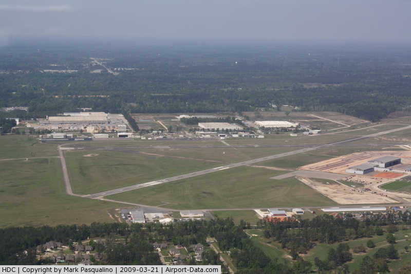
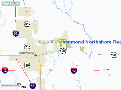
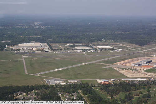
Hammond Northshore Regional Airport (ICAO: KHDC, FAA LID: HDC) is a city-owned public-use airport located three nautical miles (6 km) northeast of the central business district of Hammond, a city in Tangipahoa Parish, Louisiana, United States.
Although most U.S. airports use the same three-letter location identifier for the FAA and IATA, this airport is assigned HDC by the FAA but has no designation from the IATA. Facilities and aircraft
Hammond Northshore Regional Airport covers an area of 920 acres (372 ha) at an elevation of 47 feet (14 m) above mean sea level. It has two runways: 13/31 is 6,502 by 100 feet (1,982 x 30 m) with an asphalt/concrete surface; 18/36 is 5,001 by 150 feet (1,524 x 46 m) with a concrete surface.
For the 12-month period ending April 16, 2008, the airport had 76,850 aircraft operations, an average of 210 per day: 82% general aviation, 16% military and 2% air taxi. At that time there were 113 aircraft based at this airport: 67% single-engine, 18% military, 9% multi-engine, 5% jet and 1% helicopter.
The Louisiana Army National Guard maintains a 56-acre campus (constructed in 2008-2009) at the Hammond airport, which is home to the 1/244th Air Assault Helicopter Battalion, which operates UH-60 Blackhawk helicopters, and the 204th Theater Air Operation Command.
History
During World War II, part of the airport served as a detention camp for prisoners of war from Germany.
The above content comes from Wikipedia and is published under free licenses – click here to read more.
|
 |
(Click on the photo to enlarge) |
Location &
QuickFacts
|
FAA
Information Effective: |
2008-09-25 |
|
Airport
Identifier: |
HDC |
|
Airport
Status: |
Operational |
|
Longitude/Latitude: |
090-25-06.1707W/30-31-18.0747N
-90.418381/30.521687 (Estimated) |
|
Elevation: |
47 ft / 14.33 m (Estimated) |
|
Land: |
920 acres |
|
From
nearest city: |
3 nautical miles NE of Hammond, LA |
|
Location: |
Tangipahoa Parish, LA |
|
Magnetic Variation: |
03E (1990) |
Owner & Manager
|
Ownership: |
Publicly owned |
|
Owner: |
City Of Hammond |
|
Address: |
Po Box 2788
Hammond, LA 70404-2788 |
|
Phone
number: |
985-277-5600 |
|
Manager: |
Jason Ball |
|
Address: |
600 Judge Leon Ford Drive
Hammond, LA 70401 |
|
Phone number: |
985-277-5667
OR 985-543-0445 (HOME). |
Airport Operations and Facilities
|
Airport
Use: |
Open to public |
|
Wind
indicator: |
Yes |
|
Segmented Circle: |
No |
|
Control
Tower: |
No |
|
Lighting
Schedule: |
DUSK-DAWN
MIRL & TWY LGTS RYS 13/31 & 18/36; REIL RYS 13 & 31 AND MALSR RY 18
PRESET LOW INTST DUSK-DAWN; TO INCR INTST ACTVT - CTAF. |
|
Beacon
Color: |
Clear-Green (lighted land airport) |
|
Landing
fee charge: |
No |
|
Sectional chart: |
New Orleans |
|
Region: |
ASW - Southwest |
|
Traffic
Pattern Alt: |
956 ft |
|
Boundary
ARTCC: |
ZHU - Houston |
|
Tie-in
FSS: |
DRI - De Ridder |
|
FSS on
Airport: |
No |
|
FSS Toll
Free: |
1-800-WX-BRIEF |
|
NOTAMs
Facility: |
DRI (NOTAM-d service avaliable) |
|
Federal Agreements: |
NGPY3 |
Airport Communications
|
CTAF: |
122.700 |
|
Unicom: |
122.700 |
Airport Services
|
Fuel
available: |
100LLA
SELF SERVICE FUEL AVBL 24 HRS WITH CREDIT CARD ON WEST RAMP.
FULL SERVICE AVBL ON SE RAMP. |
|
Airframe
Repair: |
MAJOR |
|
Power
Plant Repair: |
MAJOR |
|
Bottled
Oxygen: |
NONE |
|
Bulk
Oxygen: |
NONE |
|
Runway Information
Runway 13/31
|
Dimension: |
6502 x 100 ft / 1981.8 x 30.5 m |
|
Surface: |
ASPH-CONC, Good Condition |
|
Weight Limit: |
Single wheel: 22000 lbs.
Dual wheel: 33000 lbs. |
|
Edge Lights: |
Medium |
|
|
Runway 13
|
Runway 31
|
|
Longitude: |
090-25-30.5336W |
090-24-37.5192W |
|
Latitude: |
30-31-40.5352N |
30-30-55.4253N |
|
Elevation: |
46.00 ft |
40.00 ft |
|
Alignment: |
127 |
127 |
|
Traffic
Pattern: |
Left |
Left |
|
Markings: |
Non-precision instrument, Good Condition |
Non-precision instrument, Good Condition |
|
Crossing
Height: |
50.00 ft |
50.00 ft |
|
Displaced
threshold: |
0.00 ft |
690.00 ft |
|
VASI: |
4-light PAPI on left side |
4-light PAPI on left side |
|
Visual
Glide Angle: |
3.30° |
3.30° |
|
Runway End
Identifier: |
Yes |
Yes |
|
Obstruction: |
60 ft trees, 2600.0 ft from runway, 40:1 slope to clear |
70 ft trees, 1150.0 ft from runway, 250 ft right of
centerline, 13:1 slope to clear
APCH SLOPE 24:1 TO DSPLCD THLD. |
|
Runway 18/36
|
Dimension: |
5001 x 150 ft / 1524.3 x 45.7 m |
|
Surface: |
CONC, Fair Condition |
|
Weight Limit: |
Single wheel: 27000 lbs.
Dual wheel: 41000 lbs. |
|
Edge Lights: |
Medium |
|
|
Runway 18
|
Runway 36
|
|
Longitude: |
090-25-09.2010W |
090-25-08.7160W |
|
Latitude: |
30-31-42.9470N |
30-30-53.4480N |
|
Elevation: |
44.00 ft |
40.00 ft |
|
Alignment: |
127 |
127 |
|
ILS Type: |
ILS |
|
|
Traffic
Pattern: |
Left |
Left |
|
Markings: |
Precision instrument, Fair Condition |
Precision instrument, Fair Condition |
|
Crossing
Height: |
52.00 ft |
52.00 ft |
|
VASI: |
4-light PAPI on left side |
4-light PAPI on left side |
|
Visual
Glide Angle: |
3.00° |
3.00° |
|
Approach
lights: |
MALSR |
|
|
Runway End
Identifier: |
Yes |
Yes |
|
Obstruction: |
, 50:1 slope to clear |
30 ft pline, 1000.0 ft from runway, 26:1 slope to clear |
|
Radio Navigation Aids
|
ID |
Type |
Name |
Ch |
Freq |
Var |
Dist |
|
MS |
NDB |
Kinte |
|
338.00 |
03E |
29.9 nm |
|
FNA |
NDB |
Florenville |
|
371.00 |
03E |
31.6 nm |
|
DEF |
NDB |
Slidell |
|
256.00 |
03E |
33.2 nm |
|
BX |
NDB |
Carma |
|
353.00 |
02E |
36.0 nm |
|
MJD |
NDB |
Picayune |
|
276.00 |
01E |
39.7 nm |
|
MC |
NDB |
Ferni |
|
413.00 |
03E |
44.3 nm |
|
HMU |
VOR |
Hammond |
|
109.60 |
03E |
0.1 nm |
|
RQR |
VOR/DME |
Reserve |
045X |
110.80 |
02E |
27.6 nm |
|
PCU |
VOR/DME |
Picayune |
059X |
112.20 |
05E |
35.7 nm |
|
BTR |
VORTAC |
Baton Rouge |
112X |
116.50 |
06E |
45.4 nm |
|
HRV |
VORTAC |
Harvey |
088X |
114.10 |
02E |
45.8 nm |
|
MCB |
VORTAC |
Mc Comb |
114X |
116.70 |
03E |
47.8 nm |
|
NEW |
VOT |
New Orleans Lakefront |
|
111.00 |
|
35.4 nm |
Remarks
-
EXCAVATED AREAS
WHERE DRAINAGE WAS REMOVED ARE BEGINNING TO ERODE INTO RY 18/36 SAFETY AREA.
-
ELECTRONIC EQUIP,
OPEN DITCHES & EROSION WITHIN SAFETY AREA AER 36.
-
RY 18/36 ALL
SAFETY AREAS NSTD.
-
TWYS WEST OF RY
18 UNLGTD.
-
PAEW NW END RY 13/31.
-
TWYS A & E WEST
OF RY 18/36 LGTS OTS INDEFLY.
-
BIRDS, DEER &
COYOTES ON & INVOF ARPT.
-
UNMKD N/S TWY ADJ
RY 18/36 CLSD TO ACFT OVER 80,000 LBS.
-
TRANSIENT PARKING
& MIL & GOVT ACFT SERVICED AT SE APRON AT THE FBO.
-
ULTRALIGHT
ACTIVITY ON & INVOF ARPT.
Based Aircraft
|
Aircraft based
on field: |
113 |
|
Single Engine
Airplanes: |
76 |
|
Multi Engine
Airplanes: |
10 |
|
Jet Engine
Airplanes: |
6 |
|
Helicopters: |
1 |
|
Military: |
20 |
Operational Statistics
Time Period: 2007-04-18 - 2008-04-16
|
Aircraft
Operations: |
211/Day |
|
Air Taxi: |
2.0% |
|
General
Aviation Local: |
49.2% |
|
General
Aviation Itinerant: |
33.2% |
|
Military: |
15.6% |
Hammond Northshore Regional Airport
Address:
Tangipahoa Parish, LA
Tel:
985-277-5600,
985-277-5667
Images
and information placed above are from
http://www.airport-data.com/airport/HDC/
We
thank them for the data!
|
General Info |
| Country |
United
States |
| State |
LOUISIANA |
| FAA ID |
HDC
|
| Latitude |
30-31-15.488N |
|
Longitude |
090-25-03.434W |
|
Elevation |
44 feet
|
| Near
City |
HAMMOND
|
We don't guarantee the information is fresh and accurate. The data may
be wrong or outdated.
For more up-to-date information please refer to other sources.
|
|