|
|
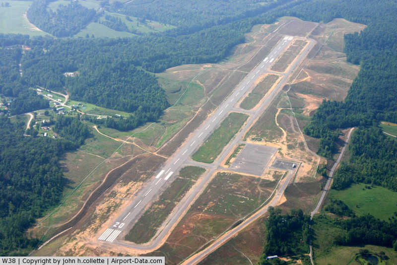
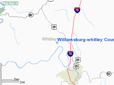
Williamsburg-whitley County Airport |
|
 |
(Click on the photo to enlarge) |
|
Location &
QuickFacts
|
FAA
Information Effective: |
2008-09-25 |
|
Airport
Identifier: |
W38 |
|
Airport
Status: |
Operational |
|
Longitude/Latitude: |
084-11-58.3000W/36-47-42.0000N
-84.199528/36.795000 (Estimated) |
|
Elevation: |
1178 ft / 359.05 m (Surveyed) |
|
Land: |
500 acres |
|
From
nearest city: |
4 nautical miles NN of Williamsburg, KY |
|
Location: |
Whitley County, KY |
|
Magnetic Variation: |
05W (2005) |
Owner & Manager
|
Ownership: |
Publicly owned |
|
Owner: |
Williamsburg-whitley Cnty Apt Board |
|
Address: |
P. O. Box 312
Williamsburg, KY 40769 |
|
Phone
number: |
606-549-2688 |
|
Manager: |
Dan Dickten |
|
Address: |
P.o. Box 312
Williamsburg, KY 40769 |
|
Phone number: |
606-549-2688 |
Airport Operations and Facilities
|
Airport
Use: |
Open to public |
|
Wind
indicator: |
Yes |
|
Segmented Circle: |
Yes |
|
Control
Tower: |
No |
|
Lighting
Schedule: |
DUSK-DAWN
ACTVT MIRL RYS 2/20, REILS RY 2 & RY 20 - CTAF. |
|
Beacon
Color: |
Clear-Green (lighted land airport) |
|
Sectional chart: |
Cincinnati |
|
Region: |
ASO - Southern |
|
Boundary
ARTCC: |
ZID - Indianapolis |
|
Tie-in
FSS: |
LOU - Louisville |
|
FSS Toll
Free: |
1-800-WX-BRIEF |
|
NOTAMs
Facility: |
LOU (NOTAM-d service avaliable) |
|
Federal Agreements: |
NGY |
Airport Communications
|
CTAF: |
122.700 |
|
Unicom: |
122.700 |
Airport Services
|
Runway Information
Runway 02/20
|
Dimension: |
5500 x 100 ft / 1676.4 x 30.5 m |
|
Surface: |
ASPH, Good Condition |
|
Weight Limit: |
Single wheel: 30000 lbs.
Dual wheel: 45000 lbs. |
|
Edge Lights: |
Medium |
|
|
Runway 02
|
Runway 20
|
|
Longitude: |
084-12-08.6234W |
084-11-47.9025W |
|
Latitude: |
36-47-16.1229N |
36-48-07.8710N |
|
Elevation: |
1156.00 ft |
1178.00 ft |
|
Traffic
Pattern: |
Left |
Left |
|
Markings: |
Non-precision instrument, Good Condition |
Non-precision instrument, Good Condition |
|
Crossing
Height: |
35.00 ft |
30.00 ft |
|
VASI: |
4-light PAPI on left side |
4-light PAPI on left side |
|
Visual
Glide Angle: |
3.17° |
3.17° |
|
Runway End
Identifier: |
Yes |
Yes |
|
Obstruction: |
410 ft trees, 12300.0 ft from runway, 500 ft left of
centerline, 30:1 slope to clear |
147 ft trees, 5200.0 ft from runway, 300 ft right of
centerline, 34:1 slope to clear |
|
Radio Navigation Aids
|
ID |
Type |
Name |
Ch |
Freq |
Var |
Dist |
|
BPO |
NDB |
Piney Grove |
|
403.00 |
05W |
20.3 nm |
|
CDX |
NDB |
Cumberland River |
|
388.00 |
05E |
26.1 nm |
|
JAU |
NDB |
Jacksboro |
|
204.00 |
03W |
27.5 nm |
|
EKQ |
NDB |
Elk Spring |
|
290.00 |
03W |
31.7 nm |
|
LOZ |
VORTAC |
London |
108X |
116.10 |
03W |
14.9 nm |
|
LVT |
VORTAC |
Livingston |
021X |
108.40 |
02W |
48.3 nm |
Based Aircraft
|
Aircraft based
on field: |
7 |
|
Single Engine
Airplanes: |
5 |
|
Multi Engine
Airplanes: |
1 |
|
Helicopters: |
1 |
Operational Statistics
Time Period: 2006-04-10 - 2007-04-09
|
Aircraft
Operations: |
9/Month |
|
General
Aviation Local: |
50.0% |
|
General
Aviation Itinerant: |
50.0% |
Williamsburg-whitley County Airport
Address:
Whitley County, KY
Tel:
606-549-2688
Images
and information placed above are from
http://www.airport-data.com/airport/W38/
We
thank them for the data!
|
General Info |
| Country |
United
States |
| State |
KENTUCKY
|
| FAA ID |
W38
|
| Latitude |
36.795008
36° 47' 42.03" N |
|
Longitude |
-84.199525
084° 11' 58.29" W |
|
Elevation |
1178
feet
359 meters |
| Magnetic
Variation |
005° W
(01/06) |
|
Operating Agency |
U.S.CIVIL AIRPORT WHEREIN PERMIT COVERS USE BY TRANSIT MILITARY
AIRCRAFT |
We don't guarantee the information is fresh and accurate. The data may
be wrong or outdated.
For more up-to-date information please refer to other sources.
|
|