 |
|
Coordinates: 37°23â²15â³N 083°15â²42â³W / 37.3875°N 83.26167°W / 37.3875; -83.26167
| Wendell H. Ford Airport |
| IATA: none â ICAO: none â FAA LID: K20 |
| Summary |
| Airport type |
Public |
| Owner |
Hazard-Perry County Board |
| Serves |
Hazard, Kentucky |
| Elevation AMSL |
1,253 ft / 382 m |
| Runways |
| Direction |
Length |
Surface |
| ft |
m |
| 14/32 |
5,500 |
1,676 |
Asphalt |
| 6/24 |
3,250 |
991 |
Asphalt |
| Statistics (2006) |
| Aircraft operations |
10,200 |
| Source: Federal Aviation Administration |
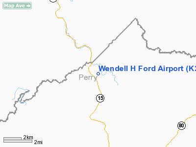
Wendell H. Ford Airport (FAA LID: K20) is a public airport located 10 miles (16 km) northwest of the central business district of Hazard, a city in Perry County, Kentucky, United States. It is named for former Kentucky Senator and Governor Wendell H. Ford.
Facilities and aircraft
Wendell H. Ford Airport covers an area of 37 acres (15 ha) which contains two asphalt paved runways: 14/32 measuring 5,500 x 100 ft (1,676 x 30 m) and 6/24 measuring 3,250 x 60 ft (991 x 18 m). For the 12-month period ending September 21, 2006, the airport had 10,200 aircraft operations, an average of 27 per day: 85% general aviation, 13% air taxi and 2% military.
The above content comes from Wikipedia and is published under free licenses – click here to read more.
|
Location &
QuickFacts
|
FAA
Information Effective: |
2008-09-25 |
|
Airport
Identifier: |
K20 |
|
Airport
Status: |
Operational |
|
Longitude/Latitude: |
083-15-41.7410W/37-23-14.5270N
-83.261595/37.387369 (Estimated) |
|
Elevation: |
1253 ft / 381.91 m (Surveyed) |
|
Land: |
37 acres |
|
From
nearest city: |
10 nautical miles NW of Hazard, KY |
|
Location: |
Perry County, KY |
|
Magnetic Variation: |
04W (1990) |
Owner & Manager
|
Ownership: |
Publicly owned |
|
Owner: |
Hazard-perry County Board |
|
Address: |
P.o. Box 420
Hazard, KY 41702 |
|
Phone number: |
606-436-3171 |
|
Manager: |
Jeff Hylton |
|
Address: |
Po Box 2346
Hazard, KY 41701 |
|
Phone number: |
606-439-5140 |
Airport
Operations and Facilities
|
Airport
Use: |
Open to public |
|
Wind
indicator: |
Yes |
|
Segmented Circle: |
Yes |
|
Control
Tower: |
No |
|
Lighting
Schedule: |
DUSK-DAWN
ACTVT MIRL RY 14/32, REIL RYS 14 & 32 AND PAPI RYS 14 & 32 - CTAF. |
|
Beacon
Color: |
Clear-Green (lighted land airport) |
|
Landing
fee charge: |
Yes
RAMP FEES. |
|
Sectional chart: |
Cincinnati |
|
Region: |
ASO - Southern |
|
Boundary
ARTCC: |
ZID - Indianapolis |
|
Tie-in
FSS: |
LOU - Louisville |
|
FSS on
Airport: |
No |
|
FSS Toll
Free: |
1-800-WX-BRIEF |
|
NOTAMs
Facility: |
LOU (NOTAM-d service avaliable) |
|
Federal Agreements: |
N |
Airport Communications
|
CTAF: |
122.700 |
|
Unicom: |
122.700 |
Airport Services
|
Fuel
available: |
100LLA |
|
Airframe
Repair: |
NONE |
|
Power
Plant Repair: |
NONE |
|
Bottled
Oxygen: |
NONE |
|
Bulk
Oxygen: |
NONE |
|
Runway Information
Runway 06/24
|
Dimension: |
3250 x 60 ft / 990.6 x 18.3 m |
|
Surface: |
ASPH, Fair Condition |
|
Weight Limit: |
Single wheel: 12000 lbs. |
|
|
Runway 06
|
Runway 24
|
|
Longitude: |
083-16-11.2100W |
083-15-36.6100W |
|
Latitude: |
37-23-22.0400N |
37-23-38.4300N |
|
Elevation: |
1243.00 ft |
1242.00 ft |
|
Alignment: |
59 |
127 |
|
Traffic
Pattern: |
Left |
Left |
|
Markings: |
Basic, Fair Condition |
Basic, Fair Condition |
|
Displaced
threshold: |
277.00 ft
DSPLCD THR LGTS 65 FT W OF MARKED DSPLCD THR. RY 24 DSPLCD THR LGTS 10
FT E OF MARKED DSPLCD THR. |
282.00 ft |
|
Obstruction: |
, 50:1 slope to clear |
315 ft trees, 3203.0 ft from runway, 438 ft left of
centerline, 9:1 slope to clear
APCH RATIO 11:1 TO DSPLCD THR.
15 FT BRUSH 25 FT FM RY END BOTH SIDES OF CNTRLN. |
|
Runway 14/32
|
Dimension: |
5500 x 100 ft / 1676.4 x 30.5 m |
|
Surface: |
ASPH, Good Condition |
|
Weight Limit: |
Single wheel: 30000 lbs. |
|
Edge Lights: |
Medium |
|
|
Runway 14
|
Runway 32
|
|
Longitude: |
083-15-56.9700W |
083-15-12.1429W |
|
Latitude: |
37-23-25.7300N |
37-22-44.7743N |
|
Elevation: |
1243.00 ft |
1253.00 ft |
|
Alignment: |
127 |
127 |
|
Traffic
Pattern: |
Left |
Left |
|
Markings: |
Non-precision instrument, Fair Condition |
Non-precision instrument, |
|
Crossing
Height: |
29.00 ft |
38.00 ft |
|
VASI: |
4-light PAPI on left side |
4-light PAPI on right side
UNUSBL BYD 2.5 NM. UNUSBL BYD 7 DEG RIGHT OF FINAL & BYD 5 DEG LEFT OF
FINAL |
|
Visual
Glide Angle: |
3.00° |
4.00° |
|
Runway End
Identifier: |
Yes |
Yes |
|
Obstruction: |
227 ft trees, 6700.0 ft from runway, 200 ft right of
centerline, 28:1 slope to clear |
200 ft hill, 4200.0 ft from runway, 20:1 slope to clear |
|
Radio Navigation Aids
|
ID |
Type |
Name |
Ch |
Freq |
Var |
Dist |
|
LQV |
NDB |
Long Hollow |
|
252.00 |
03W |
41.9 nm |
|
XYC |
NDB |
Seco |
|
393.00 |
03W |
42.9 nm |
|
AZQ |
VOR/DME |
Hazard |
049X |
111.20 |
04W |
0.2 nm |
|
LOZ |
VORTAC |
London |
108X |
116.10 |
03W |
45.9 nm |
|
ECB |
VORTAC |
Newcombe |
041X |
110.40 |
02W |
49.3 nm |
Based Aircraft
|
Aircraft based
on field: |
33 |
|
Single Engine
Airplanes: |
18 |
|
Multi Engine
Airplanes: |
12 |
|
Jet Engine
Airplanes: |
2 |
|
Helicopters: |
1 |
Operational Statistics
Time Period: 2005-09-22 - 2006-09-21
|
Aircraft
Operations: |
197/Week |
|
Air Taxi: |
12.7% |
|
General
Aviation Local: |
39.2% |
|
General
Aviation Itinerant: |
46.1% |
|
Military: |
2.0% |
Wendell H Ford Airport
Address:
Perry County, KY
Tel:
606-436-3171, 606-439-5140
Images
and information placed above are from
http://www.airport-data.com/airport/K20/
We
thank them for the data!
|
General Info |
| Country |
United
States |
| State |
KENTUCKY
|
| FAA ID |
K20
|
| Latitude |
37-23-16.218N |
|
Longitude |
083-15-43.412W |
|
Elevation |
1253
feet |
| Near
City |
HAZARD
|
We don't guarantee the information is fresh and accurate. The data may
be wrong or outdated.
For more up-to-date information please refer to other sources.
|
|


