 |
|
|
|
|
|
|
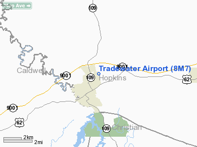
Location &
QuickFacts
|
FAA
Information Effective: |
2008-09-25 |
|
Airport
Identifier: |
8M7 |
|
Airport
Status: |
Operational |
|
Longitude/Latitude: |
087-40-30.0230W/37-11-20.1650N
-87.675006/37.188935 (Estimated) |
|
Elevation: |
405 ft / 123.44 m (Estimated) |
|
Land: |
27 acres |
|
From
nearest city: |
2 nautical miles NE of Dawson Springs, KY |
|
Location: |
Hopkins County, KY |
|
Magnetic Variation: |
00E (1985) |
Owner & Manager
|
Ownership: |
Publicly owned |
|
Owner: |
Dawson Springs |
|
Address: |
320 E Rosedale Lane
Dawson Springs, KY 42408 |
|
Phone
number: |
502-797-4561 |
|
Manager: |
Herbert Chaney |
|
Address: |
320 E Rosedale Lane
Dawson Springs, KY 42408 |
|
Phone number: |
502-797-4561 |
Airport Operations and Facilities
|
Airport
Use: |
Open to public |
|
Wind
indicator: |
Yes
LCTD INSIDE OBJECT FREE AREA 99.14 FT FM RY CNTRLN. |
|
Segmented Circle: |
Yes |
|
Control
Tower: |
No |
|
Landing
fee charge: |
No |
|
Sectional chart: |
St Louis |
|
Region: |
ASO - Southern |
|
Boundary
ARTCC: |
ZME - Memphis |
|
Tie-in
FSS: |
LOU - Louisville |
|
FSS on
Airport: |
No |
|
FSS Toll
Free: |
1-800-WX-BRIEF |
|
NOTAMs
Facility: |
LOU (NOTAM-d service avaliable) |
Airport Communications
Airport Services
|
Airframe
Repair: |
NONE |
|
Power
Plant Repair: |
NONE |
|
Bottled
Oxygen: |
NONE |
|
Bulk
Oxygen: |
NONE |
|
Runway Information
Runway 18/36
|
Dimension: |
2875 x 80 ft / 876.3 x 24.4 m |
|
Surface: |
TURF, Good Condition |
|
|
Runway 18
|
Runway 36
|
|
Traffic
Pattern: |
Left |
Left |
|
Obstruction: |
30 ft trees, 483.0 ft from runway, 10 ft right of
centerline, 16:1 slope to clear |
, 50:1 slope to clear |
|
Radio Navigation Aids
|
ID |
Type |
Name |
Ch |
Freq |
Var |
Dist |
|
TWT |
NDB |
Tradewater |
|
276.00 |
00E |
21.2 nm |
|
HIX |
NDB |
Honey Grove |
|
356.00 |
01W |
24.6 nm |
|
GMH |
NDB |
Muhlenberg |
|
362.00 |
01E |
24.8 nm |
|
FK |
NDB |
Airbe |
|
273.00 |
01W |
29.9 nm |
|
GVA |
NDB |
Geneva |
|
224.00 |
01W |
37.2 nm |
|
BDD |
NDB |
Bellgrade |
|
254.00 |
00E |
47.8 nm |
|
HXW |
TACAN |
Screaming Eagle |
096X |
|
01W |
32.0 nm |
|
CKV |
VOR/DME |
Clarksville |
043X |
110.60 |
01W |
36.3 nm |
|
OWB |
VOR/DME |
Owensboro |
023X |
108.60 |
01E |
41.2 nm |
|
CCT |
VORTAC |
Central City |
035X |
109.80 |
01W |
22.9 nm |
|
PXV |
VORTAC |
Pocket City |
080X |
113.30 |
03E |
44.6 nm |
Remarks
Based Aircraft
|
Aircraft based
on field: |
3 |
|
Single Engine
Airplanes: |
3 |
Operational Statistics
Time Period: 2005-02-03 - 2006-02-02
|
Aircraft
Operations: |
19/Week |
|
General
Aviation Local: |
47.4% |
|
General
Aviation Itinerant: |
47.4% |
|
Military: |
5.3% |
Tradewater Airport
Address:
Hopkins County, KY
Tel:
502-797-4561
Images
and information placed above are from
http://www.airport-data.com/airport/8M7/
We
thank them for the data!
|
General Info |
| Country |
United
States |
| State |
KENTUCKY
|
| FAA ID |
8M7
|
| Latitude |
37-11-20.165N |
|
Longitude |
087-40-30.023W |
|
Elevation |
405 feet
|
| Near
City |
DAWSON
SPRINGS |
We don't guarantee the information is fresh and accurate. The data may
be wrong or outdated.
For more up-to-date information please refer to other sources.
|
|


