 |
|
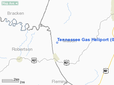
Tennessee Gas Greenup Heliport |
|
Location &
QuickFacts
|
FAA
Information Effective: |
2008-09-25 |
|
Airport
Identifier: |
0KY3 |
|
Airport
Status: |
Operational |
|
Longitude/Latitude: |
083-57-10.0000W/38-33-41.0000N
-83.952778/38.561389 (Estimated) |
|
Elevation: |
604 ft / 184.10 m (Estimated) |
|
Land: |
0 acres |
|
From
nearest city: |
9 nautical miles SW of Load, KY |
|
Location: |
Greenup County, KY |
|
Magnetic Variation: |
04W (1990) |
Owner & Manager
|
Ownership: |
Privately owned |
|
Owner: |
Tennessee Gas Pipeline Co. |
|
Address: |
Route 7
Load, KY 41144 |
|
Phone number: |
606-473-9829 |
|
Manager: |
Orville Ward
DISTRICT SUPERINTENDENT. |
|
Address: |
Route 7
Load, KY 41144 |
|
Phone number: |
606-473-9829 |
Airport
Operations and Facilities
|
Airport
Use: |
Private |
|
Segmented Circle: |
No |
|
Control
Tower: |
No |
|
Sectional chart: |
Cincinnati |
|
Region: |
ASO - Southern |
|
Boundary
ARTCC: |
ZID - Indianapolis |
|
Tie-in
FSS: |
LOU - Louisville |
|
FSS on
Airport: |
No |
|
FSS Toll
Free: |
1-800-WX-BRIEF |
|
Runway Information
Helipad H1
|
Dimension: |
30 x 30 ft / 9.1 x 9.1 m |
|
Surface: |
CONC, |
|
|
Runway H1
|
Runway
|
|
Traffic
Pattern: |
Left |
Left |
|
Radio Navigation Aids
|
ID |
Type |
Name |
Ch |
Freq |
Var |
Dist |
|
XW |
NDB |
Flmng |
|
400.00 |
05W |
14.4 nm |
|
AMT |
NDB |
West Union |
|
359.00 |
04W |
25.4 nm |
|
IOB |
NDB |
Mount Sterling |
|
210.00 |
04W |
30.2 nm |
|
PWF |
NDB |
Sportys |
|
245.00 |
04W |
33.3 nm |
|
PZO |
NDB |
Peebles |
|
329.00 |
02W |
36.5 nm |
|
LUK |
NDB |
Cincinnati |
|
335.00 |
04W |
40.3 nm |
|
HOC |
NDB |
Hillsboro |
|
278.00 |
05W |
42.1 nm |
|
MDE |
NDB |
Madeira |
|
379.00 |
04W |
44.0 nm |
|
FEU |
NDB |
Arnold |
|
521.00 |
03W |
45.9 nm |
|
ISZ |
NDB |
Cincinnati-blue Ash |
|
388.00 |
04W |
46.1 nm |
|
HW |
NDB |
Cubla |
|
299.00 |
04W |
47.7 nm |
|
LE |
NDB |
Blayd |
|
242.00 |
04W |
48.0 nm |
|
UR |
NDB |
Burln |
|
321.00 |
04W |
48.2 nm |
|
XYC |
NDB |
Seco |
|
393.00 |
03W |
48.4 nm |
|
FLM |
VOR/DME |
Falmouth |
117X |
117.00 |
04W |
17.6 nm |
|
HYK |
VORTAC |
Lexington |
073X |
112.60 |
00E |
43.4 nm |
|
CVG |
VORTAC |
Cincinnati |
120X |
117.30 |
04W |
44.5 nm |
|
YRK |
VORTAC |
York |
075X |
112.80 |
05W |
46.0 nm |
|
LUK |
VOT |
Cincinnati Muni/lunken |
|
108.40 |
|
39.4 nm |
Remarks
-
PROVIDED VFR/PR
USE; ALL APCH/DEP ROUTE HEL OPNS ARE FROM 130-310 DEG; AREA APPROPRIATELY MKD;
A WIND INDICATOR IS MNTND.
Tennessee Gas Greenup Heliport
Address:
Greenup County, KY
Tel:
606-473-9829
Images
and information placed above are from
http://www.airport-data.com/airport/0KY3/
We
thank them for the data!
|
General Info |
| Country |
United
States |
| State |
KENTUCKY
|
| FAA ID |
0KY3
|
| Latitude |
38-33-41.000N |
|
Longitude |
083-57-10.000W |
|
Elevation |
604 feet
|
| Near
City |
LOAD
|
We don't guarantee the information is fresh and accurate. The data may
be wrong or outdated.
For more up-to-date information please refer to other sources.
|
|


