 |
|
Paintsville - Prestonsburg - Combs Field Airport |
| Paintsville-Prestonsburg Combs Field |
| IATA: none â ICAO: none â FAA LID: 9KY9
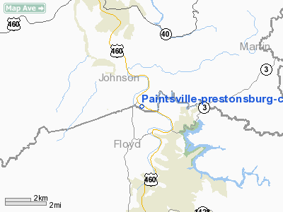
Location of Paintsville-Prestonsburg Combs Field
|
| Summary |
| Airport type |
Publicly owned, Private use |
| Owner |
Paintsville-Prestonsburg Air Board |
| Serves |
Paintsville / Prestonsburg |
| Location |
Hager Hill, Kentucky |
| Elevation AMSL |
624 ft / 190 m |
| Coordinates |
37°44â²45â³N 082°46â²45â³W / 37.74583°N 82.77917°W / 37.74583; -82.77917 |
| Runways |
| Direction |
Length |
Surface |
| ft |
m |
| 13/31 |
3,070 |
936 |
Asphalt |
| Statistics (2005) |
| Aircraft operations |
5,830 |
| Based aircraft |
10 |
| Source: Federal Aviation Administration |
Paintsville-Prestonsburg Combs Field (FAA LID: 9KY9) is a publicly-owned, private-use airport located four nautical miles (7 km) southeast of the central business district of Paintsville, in Johnson County, Kentucky, United States. It is owned by the Paintsville-Prestonsburg Air Board. The airport officially opened on August 1, 1964.
Facilities and aircraft
Paintsville-Prestonsburg Combs Field covers an area of 25 acres (10 ha) at an elevation of 624 feet (190 m) above mean sea level. It has one asphalt paved runway designated 13/31 which measures 3,070 by 75 feet (936 by 23 meters).
For the 12-month period ending December 21, 2005, the airport had 5,830 aircraft operations, an average of 15 per day: 3,000 itinerant general aviation, 1,500 local general aviation, 1,300 air taxi and 30 military. At that time there were 10 aircraft based at this airport: 100% single-engine.
The above content comes from Wikipedia and is published under free licenses – click here to read more.
|
Location &
QuickFacts
|
FAA
Information Effective: |
2008-09-25 |
|
Airport
Identifier: |
9KY9 |
|
Airport
Status: |
Operational |
|
Longitude/Latitude: |
082-46-44.5760W/37-44-45.3440N
-82.779049/37.745929 (Estimated) |
|
Elevation: |
624 ft / 190.20 m (Estimated) |
|
Land: |
25 acres |
|
From
nearest city: |
4 nautical miles SE of Paintsville, KY |
|
Location: |
Johnson County, KY |
|
Magnetic Variation: |
04W (1985) |
Owner & Manager
|
Ownership: |
Publicly owned |
|
Owner: |
Paintsville-prestonburg Air Board |
|
Address: |
Po Box 109
Ivel, KY 41642-0109 |
|
Phone
number: |
606-478-4333 |
|
Manager: |
Windell D. Stratton
AIR BOARD CHAIRMAN. |
|
Address: |
Po Box 109
Ivel, KY 41642-0109 |
|
Phone number: |
606-478-4333
ARPT PHONE 606-789-5544 OR 606-789-5300. |
Airport Operations and Facilities
|
Airport Use: |
Private |
|
Wind indicator: |
Yes |
|
Segmented Circle: |
Yes |
|
Control Tower: |
No |
|
Landing fee charge: |
No |
|
Sectional chart: |
Cincinnati |
|
Region: |
ASO - Southern |
|
Boundary ARTCC: |
ZID - Indianapolis |
|
Tie-in FSS: |
LOU - Louisville |
|
FSS on Airport: |
No |
|
FSS Toll Free: |
1-800-WX-BRIEF |
Airport
Communications
Airport Services
|
Fuel
available: |
100LLMOGAS |
|
Bottled
Oxygen: |
NONE |
|
Bulk
Oxygen: |
NONE |
|
Runway Information
Runway 13/31
|
Dimension: |
3070 x 75 ft / 935.7 x 22.9 m |
|
Surface: |
ASPH, Good Condition |
|
Weight Limit: |
Single wheel: 25000 lbs. |
|
|
Runway 13 |
Runway 31 |
|
Traffic
Pattern: |
Left |
Left |
|
Markings: |
Basic, Good Condition |
Basic, Good Condition |
|
Obstruction: |
20 ft trees, 200.0 ft from runway, 60 ft left of
centerline
RY 13 20 FT TREES 150 FT FROM RY END & 60 FT LEFT. |
57 ft trees, 610.0 ft from runway, 84 ft left of
centerline, 7:1 slope to clear
12 FT TREES 150 FT FROM RY END & 45 FT LEFT. |
|
Radio Navigation Aids
|
ID |
Type |
Name |
Ch |
Freq |
Var |
Dist |
|
AJY |
FAN MARKER |
Ashland |
|
|
03W |
48.8 nm |
|
GTC |
NDB |
Guyandot |
|
293.00 |
03W |
41.4 nm |
|
AZQ |
VOR/DME |
Hazard |
049X |
111.20 |
04W |
31.4 nm |
|
ECB |
VORTAC |
Newcombe |
041X |
110.40 |
02W |
25.6 nm |
Remarks
-
ARPT LCTD IN MTN
RIVER VALLEY.
DFCLT APPROACHES TO RY.
-
VFR ONLY
Based Aircraft
|
Aircraft based
on field: |
10 |
|
Single Engine
Airplanes: |
10 |
Operational Statistics
Time Period: 2004-12-22 - 2005-12-21
|
Aircraft
Operations: |
113/Week |
|
Air Taxi: |
22.3% |
|
General
Aviation Local: |
25.7% |
|
General
Aviation Itinerant: |
51.5% |
|
Military: |
0.5% |
Paintsville-prestonsburg-combs Field
Airport
Address:
Johnson County, KY
Tel:
606-478-4333
Images
and information placed above are from
http://www.airport-data.com/airport/9KY9/
We
thank them for the data!
|
General Info |
| Country |
United
States |
| State |
KENTUCKY
|
| FAA ID |
9KY9
|
| Time |
UTC-5(-4DT) |
| Latitude |
37.745928
37° 44' 45.34" N |
|
Longitude |
-82.779050
082° 46' 44.58" W |
|
Elevation |
624 feet
190 meters |
| Magnetic
Variation |
006° W
(01/06) |
|
Operating Agency |
PRIVATE
|
|
Operating Hours |
SEE
REMARKS FOR OPERATING HOURS OR COMMUNICATIONS FOR POSSIBLE HOURS
|
| Daylight
Saving Time |
Second
Sunday in March at 0200 to first Sunday in November at 0200 local time
(Exception Arizona and that portion of Indiana in the Eastern Time
Zone) |
We don't guarantee the information is fresh and accurate. The data may
be wrong or outdated.
For more up-to-date information please refer to other sources.
|
|


