 |
|
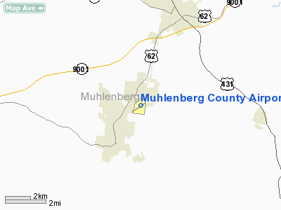
Muhlenberg County Airport |
|
|
|
Location &
QuickFacts
|
FAA
Information Effective: |
2008-09-25 |
|
Airport
Identifier: |
M21 |
|
Airport
Status: |
Operational |
|
Longitude/Latitude: |
087-09-22.9900W/37-13-34.4300N
-87.156386/37.226231 (Estimated) |
|
Elevation: |
422 ft / 128.63 m (Surveyed) |
|
Land: |
92 acres |
|
From
nearest city: |
2 nautical miles NE of Greenville, KY |
|
Location: |
Muhlenberg County, KY |
|
Magnetic Variation: |
00E (1980) |
Owner & Manager
|
Ownership: |
Publicly owned |
|
Owner: |
Muhlenberg County |
|
Address: |
Muhlenberg Co Courthouse
Greenville, KY 42345 |
|
Phone number: |
270-754-9929 |
|
Manager: |
Daniel Taylor |
|
Address: |
400 Airport Road
Greenville, KY 42345 |
|
Phone number: |
270-338-9419 |
Airport
Operations and Facilities
|
Airport
Use: |
Open to public |
|
Wind
indicator: |
Yes |
|
Control
Tower: |
No |
|
Lighting
Schedule: |
DUSK-DAWN
ACTVT MIRL RY 05/23, SAVASI RYS 05 & 23 AND REIL RYS 05 & 23 - CTAF. |
|
Beacon
Color: |
Clear-Green (lighted land airport) |
|
Landing
fee charge: |
No |
|
Sectional chart: |
St Louis |
|
Region: |
ASO - Southern |
|
Boundary
ARTCC: |
ZME - Memphis |
|
Tie-in
FSS: |
LOU - Louisville |
|
FSS on
Airport: |
No |
|
FSS Toll
Free: |
1-800-WX-BRIEF |
|
NOTAMs
Facility: |
LOU (NOTAM-d service avaliable) |
|
Federal Agreements: |
N |
Airport Communications
|
CTAF: |
123.000 |
|
Unicom: |
123.000 |
Airport Services
|
Fuel
available: |
100LLA
100LL FUEL SELF SERVE 24 HRS WITH CREDIT CARD. JET A FUEL AVBL ON
REQUEST DURG HRS ARPT ATTENDED. FOR JET A FUEL AND OTHER SVCS AFTER
HRS CALL 270-543-5198. |
|
Airframe
Repair: |
MAJOR |
|
Power
Plant Repair: |
MAJOR |
|
Bottled
Oxygen: |
NONE |
|
Bulk
Oxygen: |
NONE |
|
Runway Information
Runway 05/23
|
Dimension: |
5000 x 75 ft / 1524.0 x 22.9 m |
|
Surface: |
ASPH, Good Condition |
|
Weight Limit: |
Single wheel: 28000 lbs. |
|
Edge Lights: |
Medium |
|
|
Runway 05
|
Runway 23
|
|
Longitude: |
087-09-48.5680W |
087-08-57.4170W |
|
Latitude: |
37-13-20.5490N |
37-13-48.3110N |
|
Elevation: |
415.00 ft |
420.00 ft |
|
Alignment: |
56 |
127 |
|
Traffic
Pattern: |
Left |
Left |
|
Markings: |
Non-precision instrument, Good Condition |
Non-precision instrument, Good Condition |
|
Crossing
Height: |
30.00 ft |
25.00 ft |
|
Displaced
threshold: |
0.00 ft |
400.00 ft |
|
VASI: |
2-box SAVASI on left side |
2-box SAVASI on left side |
|
Visual
Glide Angle: |
5.00° |
5.00° |
|
Runway End
Identifier: |
Yes |
Yes |
|
Obstruction: |
10 ft road, 200.0 ft from runway, 20 ft right of
centerline
-2 FT DITCH & +10 FT BRUSH 184 FT FM RY END; PVT ROAD 189 FT FM RY END. |
67 ft road, 1672.0 ft from runway, 30 ft right of
centerline, 21:1 slope to clear
SLOPE 24:1 AT DSPLCD THLD. |
|
Radio Navigation Aids
|
ID |
Type |
Name |
Ch |
Freq |
Var |
Dist |
|
GMH |
NDB |
Muhlenberg |
|
362.00 |
01E |
0.1 nm |
|
HIX |
NDB |
Honey Grove |
|
356.00 |
01W |
22.5 nm |
|
FK |
NDB |
Airbe |
|
273.00 |
01W |
31.9 nm |
|
TWT |
NDB |
Tradewater |
|
276.00 |
00E |
40.5 nm |
|
PED |
NDB |
Needmore |
|
221.00 |
01W |
43.0 nm |
|
GVA |
NDB |
Geneva |
|
224.00 |
01W |
45.4 nm |
|
ON |
NDB |
Music |
|
279.00 |
03W |
47.4 nm |
|
HXW |
TACAN |
Screaming Eagle |
096X |
|
01W |
36.9 nm |
|
OWB |
VOR/DME |
Owensboro |
023X |
108.60 |
01E |
31.1 nm |
|
CKV |
VOR/DME |
Clarksville |
043X |
110.60 |
01W |
38.4 nm |
|
CCT |
VORTAC |
Central City |
035X |
109.80 |
01W |
10.7 nm |
|
BWG |
VORTAC |
Bowling Green |
126X |
117.90 |
02E |
38.6 nm |
Remarks
-
MKD & LGTD PLINE
UNDER RY 05 APCH; 1000 FT FM RY END.
-
EXISTED PRIOR TO 1959.
Based Aircraft
|
Aircraft based
on field: |
16 |
|
Single Engine
Airplanes: |
12 |
|
Multi Engine
Airplanes: |
2 |
|
Ultralights: |
2 |
Operational Statistics
Time Period: 2005-03-01 - 2006-02-28
|
Aircraft
Operations: |
139/Week |
|
Air Taxi: |
2.8% |
|
General
Aviation Local: |
41.5% |
|
General
Aviation Itinerant: |
55.4% |
|
Military: |
0.3% |
Muhlenberg County Airport
Address:
Muhlenberg County, KY
Tel:
270-754-9929, 270-338-9419
Images
and information placed above are from
http://www.airport-data.com/airport/M21/
We
thank them for the data!
|
General Info |
| Country |
United
States |
| State |
KENTUCKY
|
| FAA ID |
M21
|
| Latitude |
37-13-34.430N |
|
Longitude |
087-09-22.990W |
|
Elevation |
422 feet
|
| Near
City |
GREENVILLE |
We don't guarantee the information is fresh and accurate. The data may
be wrong or outdated.
For more up-to-date information please refer to other sources.
|
|


