|
|
Mount Sterling-Montgomery County Airport |
| Mount Sterling-Montgomery County Airport |
| IATA: none â ICAO: KIOB â FAA LID: IOB |
| Summary |
| Airport type |
Public |
| Owner |
Mount Sterling & Montgomery County |
| Serves |
Mount Sterling, Kentucky |
| Elevation AMSL |
1,019 ft / 311 m |
| Coordinates |
38°03â²29â³N 083°58â²46â³W / 38.05806°N 83.97944°W / 38.05806; -83.97944 |
| Runways |
| Direction |
Length |
Surface |
| ft |
m |
| 3/21 |
5,002 |
1,525 |
Asphalt |
| Statistics (2007) |
| Aircraft operations |
31,505 |
| Based aircraft |
70 |
| Source: Federal Aviation Administration |
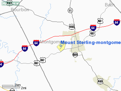
Mount Sterling-Montgomery County Airport (ICAO: KIOB, FAA LID: IOB) is a public use airport located two nautical miles (4 km) west of the central business district of Mount Sterling, a city in Montgomery County, Kentucky, United States. It is owned by the city of Mount Sterling and Montgomery County.
Although most U.S. airports use the same three-letter location identifier for the FAA and IATA, this airport is assigned IOB by the FAA but has no designation from the IATA.
Facilities and aircraft
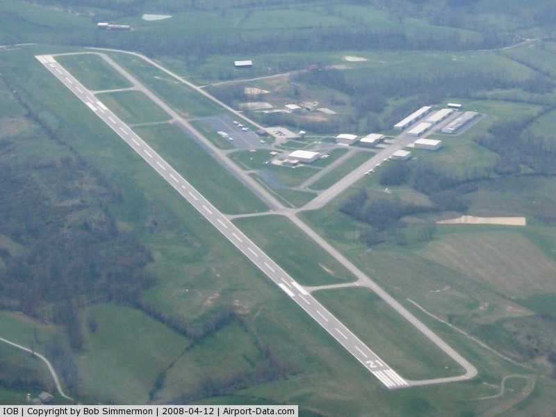
Mount Sterling-Montgomery County Airport covers an area of 53 acres (21 ha) at an elevation of 1,019 feet (311 m) above mean sea level. It has one asphalt paved runway designated 3/21 which measures 5,002 by 75 feet (1,525 x 23 m).
For the 12-month period ending August 7, 2007, the airport had 31,505 aircraft operations, an average of 86 per day: 85% general aviation, 12% air taxi and 2% military. At that time there were 70 aircraft based at this airport: 79% single-engine, 19% multi-engine, 1% jet and 1% helicopter.
The above content comes from Wikipedia and is published under free licenses – click here to read more.
|
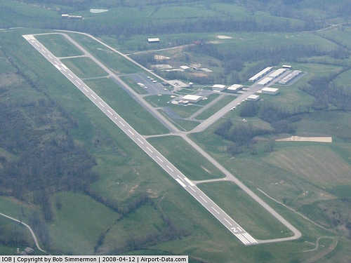 |
(Click on the photo to enlarge) |
|
Location &
QuickFacts
|
FAA
Information Effective: |
2008-09-25 |
|
Airport
Identifier: |
IOB |
|
Airport
Status: |
Operational |
|
Longitude/Latitude: |
083-58-46.5000W/38-03-29.3000N
-83.979583/38.058139 (Estimated) |
|
Elevation: |
1019 ft / 310.59 m (Surveyed) |
|
Land: |
53 acres |
|
From
nearest city: |
2 nautical miles W of Mount Sterling, KY |
|
Location: |
Montgomery County, KY |
|
Magnetic Variation: |
04W (1995) |
Owner & Manager
|
Ownership: |
Publicly owned |
|
Owner: |
Mt Sterling-montgomery County |
|
Address: |
C/o F C Bryan, Po Box 1425
Mt. Sterling, KY 40353 |
|
Phone
number: |
859-498-1442 |
|
Manager: |
Danny Hill |
|
Address: |
709 Airport Road
Mt. Sterling, KY 40353
KY AIRMOTIVE INC. |
|
Phone number: |
859-498-1000 |
Airport Operations and Facilities
|
Airport
Use: |
Open to public |
|
Wind
indicator: |
Yes |
|
Segmented Circle: |
Yes |
|
Control
Tower: |
No |
|
Lighting
Schedule: |
DUSK-DAWN
ACTVT MIRL RY 03/21, REIL RYS 03 & 21 AND PAPI RYS 03 & 21 - CTAF. |
|
Beacon
Color: |
Clear-Green (lighted land airport) |
|
Landing
fee charge: |
No |
|
Sectional chart: |
Cincinnati |
|
Region: |
ASO - Southern |
|
Boundary
ARTCC: |
ZID - Indianapolis |
|
Tie-in
FSS: |
LOU - Louisville |
|
FSS on
Airport: |
No |
|
FSS Toll
Free: |
1-800-WX-BRIEF |
|
NOTAMs
Facility: |
LOU (NOTAM-d service avaliable) |
|
Federal Agreements: |
NGY |
Airport Communications
|
CTAF: |
122.800 |
|
Unicom: |
122.800 |
Airport Services
|
Fuel
available: |
100LLA
SELF SERVICE AVBL 24 HRS. |
|
Airframe
Repair: |
MAJOR |
|
Power
Plant Repair: |
MAJOR |
|
Bottled
Oxygen: |
NONE |
|
Bulk
Oxygen: |
NONE |
|
Runway Information
Runway 03/21
|
Dimension: |
5002 x 75 ft / 1524.6 x 22.9 m |
|
Surface: |
ASPH, Good Condition |
|
Weight Limit: |
Single wheel: 20000 lbs. |
|
Edge Lights: |
Medium |
|
|
Runway 03
|
Runway 21
|
|
Longitude: |
083-59-00.7270W |
083-58-32.2050W |
|
Latitude: |
38-03-07.2880N |
38-03-51.2880N |
|
Elevation: |
1019.00 ft |
984.00 ft |
|
Alignment: |
27 |
127 |
|
Traffic
Pattern: |
Left |
Left |
|
Markings: |
Non-precision instrument, Good Condition |
Non-precision instrument, Good Condition |
|
Crossing
Height: |
0.00 ft |
30.00 ft |
|
VASI: |
4-light PAPI on left side |
2-light PAPI on left side |
|
Visual
Glide Angle: |
4.00° |
3.00° |
|
Runway End
Identifier: |
Yes |
Yes |
|
Obstruction: |
125 ft trees, 1790.0 ft from runway, 400 ft right of
centerline, 12:1 slope to clear |
10 ft tree, 240.0 ft from runway, 240 ft left of
centerline, 4:1 slope to clear |
|
Radio Navigation Aids
|
ID |
Type |
Name |
Ch |
Freq |
Var |
Dist |
|
IOB |
NDB |
Mount Sterling |
|
210.00 |
04W |
0.1 nm |
|
XYC |
NDB |
Seco |
|
393.00 |
03W |
18.2 nm |
|
LE |
NDB |
Blayd |
|
242.00 |
04W |
32.5 nm |
|
XW |
NDB |
Flmng |
|
400.00 |
05W |
34.7 nm |
|
FEU |
NDB |
Arnold |
|
521.00 |
03W |
40.8 nm |
|
DVK |
NDB |
Goodall |
|
311.00 |
03W |
47.2 nm |
|
FFT |
VOR |
Frankfort |
|
109.40 |
03W |
44.6 nm |
|
FLM |
VOR/DME |
Falmouth |
117X |
117.00 |
04W |
38.8 nm |
|
HYK |
VORTAC |
Lexington |
073X |
112.60 |
00E |
24.0 nm |
Based Aircraft
|
Aircraft based
on field: |
70 |
|
Single Engine
Airplanes: |
55 |
|
Multi Engine
Airplanes: |
13 |
|
Jet Engine
Airplanes: |
1 |
|
Helicopters: |
1 |
Operational Statistics
Time Period: 2006-08-08 - 2007-08-07
|
Aircraft
Operations: |
87/Day |
|
Air Taxi: |
12.2% |
|
General
Aviation Local: |
45.1% |
|
General
Aviation Itinerant: |
40.3% |
|
Military: |
2.4% |
Mount Sterling-montgomery County Airport
Address:
Montgomery County, KY
Tel:
859-498-1442,
859-498-1000
Images
and information placed above are from
http://www.airport-data.com/airport/IOB/
We
thank them for the data!
|
General Info |
| Country |
United
States |
| State |
KENTUCKY
|
| FAA ID |
IOB
|
| Latitude |
38-03-29.300N |
|
Longitude |
083-58-46.500W |
|
Elevation |
1019
feet |
| Near
City |
MOUNT
STERLING |
We don't guarantee the information is fresh and accurate. The data may
be wrong or outdated.
For more up-to-date information please refer to other sources.
|
|