 |
|
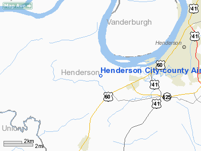
Henderson City-county Airport |
| Henderson City-County Airport |
| IATA: none â ICAO: KEHR â FAA LID: EHR |
| Summary |
| Airport type |
Public |
| Owner |
City & County of Henderson |
| Serves |
Henderson, Kentucky |
| Elevation AMSL |
387 ft / 118 m |
| Coordinates |
37°48â²28â³N 087°41â²08â³W / 37.80778°N 87.68556°W / 37.80778; -87.68556 |
| Runways |
| Direction |
Length |
Surface |
| ft |
m |
| 9/27 |
5,504 |
1,678 |
Asphalt |
| Statistics (2008) |
| Aircraft operations |
22,600 |
| Based aircraft |
44 |
| Source: Federal Aviation Administration |
Henderson City-County Airport (ICAO: KEHR, FAA LID: EHR) is a public use airport located four nautical miles (7 km) west of the central business district of Henderson, a city in Henderson County, Kentucky, United States. The airport is owned by the City & County of Henderson.
Although most U.S. airports use the same three-letter location identifier for the FAA and IATA, this airport is assigned EHR by the FAA but has no designation from the IATA.
Facilities and aircraft
Henderson City-County Airport covers an area of 80 acres (32 ha) at an elevation of 387 feet (118 m) above mean sea level. It has one asphalt paved runway designated 9/27 which measures 5,504 by 100 feet (1,678 x 30 m).
For the 12-month period ending November 17, 2008, the airport had 22,600 aircraft operations, an average of 61 per day: 91% general aviation, 9% air taxi and <1% military. At that time there were 44 aircraft based at this airport: 82% single-engine, 14% multi-engine, 2% jet and 2% helicopter.
The above content comes from Wikipedia and is published under free licenses – click here to read more.
|
Location &
QuickFacts
|
FAA
Information Effective: |
2008-09-25 |
|
Airport
Identifier: |
EHR |
|
Airport
Status: |
Operational |
|
Longitude/Latitude: |
087-41-08.5000W/37-48-28.2000N
-87.685694/37.807833 (Estimated) |
|
Elevation: |
387 ft / 117.96 m (Surveyed) |
|
Land: |
80 acres |
|
From
nearest city: |
4 nautical miles W of Henderson, KY |
|
Location: |
Henderson County, KY |
|
Magnetic Variation: |
01W (1990) |
Owner & Manager
|
Ownership: |
Publicly owned |
|
Owner: |
City & County Of Henderson
AIRPORT CHAIRMAN- T. SCOTT MILLER. |
|
Address: |
Po Box 77
Henderson, KY 42420 |
|
Phone number: |
270-826-3971
COUNTY COURTHOUSE |
|
Manager: |
Glen Stone |
|
Address: |
2154 Hwy 136 W.
Henderson, KY 42420 |
|
Phone number: |
270-826-6000
ADDL PHONE 270-827-5623. |
Airport
Operations and Facilities
|
Airport
Use: |
Open to public |
|
Wind
indicator: |
Yes |
|
Segmented Circle: |
Yes |
|
Control
Tower: |
No |
|
Lighting
Schedule: |
DUSK-DAWN
MIRL RY 09/27 PRESET LOW INTST; TO INCR INTST - CTAF.
ACTVT
PAPI RY 09 - CTAF. |
|
Beacon
Color: |
Clear-Green (lighted land airport) |
|
Landing
fee charge: |
No |
|
Sectional chart: |
St Louis |
|
Region: |
ASO - Southern |
|
Boundary
ARTCC: |
ZID - Indianapolis |
|
Tie-in
FSS: |
LOU - Louisville |
|
FSS on
Airport: |
No |
|
FSS Toll
Free: |
1-800-WX-BRIEF |
|
NOTAMs
Facility: |
EHR (NOTAM-d service avaliable) |
|
Federal Agreements: |
NGY |
Airport Communications
|
CTAF: |
122.800 |
|
Unicom: |
122.800 |
Airport Services
|
Fuel
available: |
100 A |
|
Airframe
Repair: |
MAJOR |
|
Power
Plant Repair: |
MAJOR |
|
Bottled
Oxygen: |
HIGH |
|
Bulk
Oxygen: |
HIGH |
|
Runway Information
Runway 09/27
|
Dimension: |
5504 x 100 ft / 1677.6 x 30.5 m |
|
Surface: |
ASPH, Good Condition |
|
Weight Limit: |
Single wheel: 30000 lbs. |
|
Edge Lights: |
Medium |
|
|
Runway 09
|
Runway 27
|
|
Longitude: |
087-41-42.7509W |
087-40-34.2137W |
|
Latitude: |
37-48-27.4352N |
37-48-28.9964N |
|
Elevation: |
384.00 ft |
386.00 ft |
|
Alignment: |
88 |
127 |
|
Traffic
Pattern: |
Left |
Left |
|
Markings: |
Non-precision instrument, Good Condition |
Non-precision instrument, Good Condition |
|
VASI: |
4-light PAPI on left side |
|
|
Visual
Glide Angle: |
3.00° |
0.00° |
|
Runway End
Identifier: |
Yes |
Yes |
|
Obstruction: |
50 ft trees, 1900.0 ft from runway, 100 ft right of
centerline, 34:1 slope to clear |
15 ft road, 601.0 ft from runway, 290 ft right of
centerline, 26:1 slope to clear |
|
Radio Navigation Aids
|
ID |
Type |
Name |
Ch |
Freq |
Var |
Dist |
|
GVA |
NDB |
Geneva |
|
224.00 |
01W |
4.0 nm |
|
PDW |
NDB |
Evansville |
|
284.00 |
00E |
15.8 nm |
|
TWT |
NDB |
Tradewater |
|
276.00 |
00E |
24.0 nm |
|
CUL |
NDB |
Carmi |
|
332.00 |
01W |
26.8 nm |
|
HSB |
NDB |
Harrisburg-raleigh |
|
230.00 |
00E |
40.8 nm |
|
GMH |
NDB |
Muhlenberg |
|
362.00 |
01E |
43.0 nm |
|
FNZ |
NDB |
Ferdinand |
|
239.00 |
00E |
48.1 nm |
|
AJG |
NDB |
Mount Carmel |
|
524.00 |
02W |
48.4 nm |
|
FWC |
NDB |
Wayne County |
|
257.00 |
01E |
48.5 nm |
|
TEL |
NDB |
Tell City |
|
206.00 |
02W |
48.8 nm |
|
OWB |
VOR/DME |
Owensboro |
023X |
108.60 |
01E |
25.0 nm |
|
HNB |
VOR/DME |
Huntingburg |
029X |
109.20 |
00E |
43.6 nm |
|
SAM |
VOR/DME |
Samsville |
113X |
116.60 |
03E |
44.9 nm |
|
PXV |
VORTAC |
Pocket City |
080X |
113.30 |
03E |
8.1 nm |
|
CCT |
VORTAC |
Central City |
035X |
109.80 |
01W |
32.5 nm |
Remarks
Based Aircraft
|
Aircraft based
on field: |
39 |
|
Single Engine
Airplanes: |
32 |
|
Multi Engine
Airplanes: |
5 |
|
Jet Engine
Airplanes: |
1 |
|
Helicopters: |
1 |
Operational Statistics
Time Period: 2005-02-08 - 2006-02-07
|
Aircraft
Operations: |
62/Day |
|
Air Taxi: |
8.8% |
|
General
Aviation Local: |
44.2% |
|
General
Aviation Itinerant: |
46.5% |
|
Military: |
0.4% |
Henderson City-county Airport
Address:
Henderson County, KY
Tel:
270-826-3971, 270-826-6000
Images
and information placed above are from
http://www.airport-data.com/airport/EHR/
We
thank them for the data!
|
General Info |
| Country |
United
States |
| State |
KENTUCKY
|
| FAA ID |
EHR
|
| Latitude |
37-48-28.233N |
|
Longitude |
087-41-08.484W |
|
Elevation |
386 feet
|
| Near
City |
HENDERSON |
We don't guarantee the information is fresh and accurate. The data may
be wrong or outdated.
For more up-to-date information please refer to other sources.
|
|


