|
 |
|
||||
|
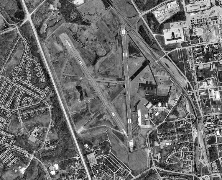
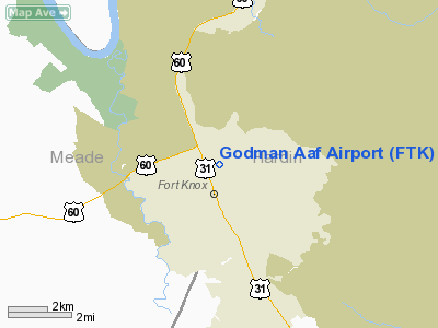
Godman Army Airfield (IATA: FTK, ICAO: KFTK, FAA LID: FTK) is a military airport located on the Fort Knox United States Army post in Hardin County, Kentucky, United States. It has four runways and is used entirely by the United States Army Aviation Branch. HistoryGodman Army Airfield was established about 1937 by the United States Army Air Corps. Its initial mission was to support Army forces at Fort Knox. In the build-up of the Army prior to the United States' entry into World War II, the 73d Observation Group was established at the airfield in November 1941, being assigned to First Air Force. The 73d's mission was to train and provide tactical reconnaissance in support of Army maneuvers. After the United States entered World War II, Godman AAF became an First Air Force group training station for B-25 Mitchell medium bomber groups. The 387th and 391st Bombardment Groups formed and trained at Godman in 1943 prior to their overseas deployment. In 1944, the mission changed to replacement training, and the 477th Bombardment Group became the B-25 Replacement Training unit. It trained replacement personnel prior to their reassignment to combat units overseas. It remained at Godman after World War II, and the airfield was designated as a permanent station of the USAAF. In 1946, Godman was reassigned to the Tenth Air Force as part of the Air Force Reserve. The 315th Army Air Force Base Unit became the host organization, and the 477th Bomb Group remained as the flying organization until its inactivation in October 1946. Redesignated as the 315th Air Force Base Unit in September 1947 with the establishment of the United States Air Force, it was further Redesignated the 2236th Air Force Reserve Training Center in July 1948. On October 10, 1950, during the Korean War, President Harry S. Truman placed the Kentucky Air National Guard 123d Fighter-Bomber Group on active duty and moved the unit from Standiford Field to Godman Field. The airfield was assigned to Tactical Air Command. The unit’s F-51 Mustangs were ferried to the Far East, and several of the unit’s pilots volunteered for combat duty over Korea. In addition to the Kentucky ANG, the New Jersey ANG 108th Fighter-Bomber Wing was federalized and brought into active service on 1 March 1951, It was assigned to the SAC 40th Air Division at Turner AFB, Georgia. In its activated configuration, the wing was composed of the 141st Fighter Squadron (New Jersey ANG), 149th Fighter Squadron (Virginia ANG) and the 153rd Fighter Squadron (Mississippi ANG). During its federal service period, the wing trained to conduct long range bombardment escort missions. On 9 December 1951, the wing was reassigned to Godman AFB. It was relieved from active service on 1 December 1952 and returned to the control of the New Jersey ANG. After the 1953 armistice in Korea, Godman was phased down and the 4430th Air Base Wing became the host organization at the base. Air Force activities were ended and the base was inactivated on 31 December 1953. It was transferred to the United States Army and became a light aircraft and helicopter airfield in support of Fort Knox. The above content comes from Wikipedia and is published under free licenses – click here to read more.
Runway Information Runway 05/23
Runway 09/27
Runway 15/33
Runway 18/36
Radio Navigation Aids
Remarks
Godman Aaf Airport Address: Hardin County, KY Tel: 502-624-6047 Images
and information placed above are from We thank them for the data!
We don't guarantee the information is fresh and accurate. The data may
be wrong or outdated.
|
||||||||||||||||||||||||||||||||||||||||||||||||||||||||||||||||||||||||||||||||||||||||||||||||||||||||||||||||||||||||||||||||||||||||||||||||||||||||||||||||||||||||||||||||||||||||||||||||||||||||||||||||||||||||||||||||||||||||||||||||||||||||||||||||||||||||||||||||||||||||||||||||||||||||||||||||||||||||||||||||||||||||||||||||||||||||||||

 |
|
Copyright 2004-2024 © by Airports-Worldwide.com, Vyshenskoho st. 36, Lviv 79010, Ukraine Legal Disclaimer |