 |
|
|
Location &
QuickFacts
|
FAA
Information Effective: |
2008-09-25 |
|
Airport
Identifier: |
3KY8 |
|
Airport
Status: |
Operational |
|
Longitude/Latitude: |
084-31-27.7100W/39-01-40.2600N
-84.524364/39.027850 (Estimated) |
|
Elevation: |
756 ft / 230.43 m (Estimated) |
|
Land: |
0 acres |
|
From
nearest city: |
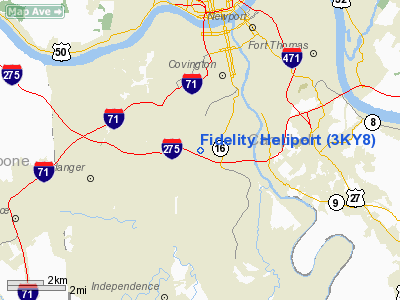
3 nautical miles S of Covington, KY |
|
Location: |
Kenton County, KY |
|
Magnetic Variation: |
04W () |
Owner & Manager
|
Ownership: |
Privately owned |
|
Owner: |
Fidelity Investments |
|
Address: |
100 Magellan Way
Covington, KY 41015 |
|
Phone number: |
606-386-7777 |
|
Manager: |
Peter Schmuck |
|
Address: |
100 Magellan Way
Covington, KY 41015 |
|
Phone number: |
606-386-7777 |
Airport
Operations and Facilities
|
Airport
Use: |
Private |
|
Wind
indicator: |
Yes |
|
Segmented Circle: |
No |
|
Control
Tower: |
No |
|
Sectional chart: |
Cincinnati |
|
Region: |
ASO - Southern |
|
Boundary
ARTCC: |
ZID - Indianapolis |
|
Tie-in
FSS: |
LOU - Louisville |
|
FSS Toll
Free: |
1-800-WX-BRIEF |
|
Runway Information
Helipad H1
|
Dimension: |
40 x 40 ft / 12.2 x 12.2 m |
|
Surface: |
CONC, |
|
|
Runway H1
|
Runway
|
|
Traffic
Pattern: |
Left |
Left |
|
Radio Navigation Aids
|
ID |
Type |
Name |
Ch |
Freq |
Var |
Dist |
|
LUK |
NDB |
Cincinnati |
|
335.00 |
04W |
11.6 nm |
|
UR |
NDB |
Burln |
|
321.00 |
04W |
11.7 nm |
|
MDE |
NDB |
Madeira |
|
379.00 |
04W |
14.1 nm |
|
ISZ |
NDB |
Cincinnati-blue Ash |
|
388.00 |
04W |
14.7 nm |
|
PWF |
NDB |
Sportys |
|
245.00 |
04W |
14.7 nm |
|
HAO |
NDB |
Hamilton |
|
260.00 |
04W |
20.9 nm |
|
HKF |
NDB |
Hook Field |
|
239.00 |
04W |
28.5 nm |
|
OXD |
NDB |
Oxford |
|
282.00 |
04W |
31.2 nm |
|
HW |
NDB |
Cubla |
|
299.00 |
04W |
36.0 nm |
|
HLB |
NDB |
Batesville |
|
254.00 |
02W |
39.3 nm |
|
IL |
NDB |
Airbo |
|
407.00 |
04W |
46.1 nm |
|
AMT |
NDB |
West Union |
|
359.00 |
04W |
46.1 nm |
|
IMS |
NDB |
Madison |
|
404.00 |
03W |
46.6 nm |
|
HOC |
NDB |
Hillsboro |
|
278.00 |
05W |
46.7 nm |
|
XW |
NDB |
Flmng |
|
400.00 |
05W |
49.3 nm |
|
XEN |
NDB |
Xenia |
|
395.00 |
03W |
49.7 nm |
|
FLM |
VOR/DME |
Falmouth |
117X |
117.00 |
04W |
24.8 nm |
|
MXQ |
VOR/DME |
Midwest |
076X |
112.90 |
04W |
41.4 nm |
|
CVG |
VORTAC |
Cincinnati |
120X |
117.30 |
04W |
8.4 nm |
|
RID |
VORTAC |
Richmond |
043X |
110.60 |
03W |
46.1 nm |
|
LUK |
VOT |
Cincinnati Muni/lunken |
|
108.40 |
|
7.9 nm |
Remarks
-
40 FT BLDG 558 FT
EAST, 10 FT PARKING GARAGE 100 FT NORTH OF HELIPAD.
-
PRVDD APCH/DEP
ALIGNED 045 AND 225 DEGS, AREA IS MKD, WIND INDICATOR IS MAINTAINED.
Fidelity Heliport
Address:
Kenton County, KY
Tel:
606-386-7777
Images
and information placed above are from
http://www.airport-data.com/airport/3KY8/
We
thank them for the data!
|
General Info |
| Country |
United
States |
| State |
KENTUCKY
|
| FAA ID |
3KY8
|
| Latitude |
39-01-39.000N |
|
Longitude |
084-01-57.000W |
|
Elevation |
800 feet
|
| Near
City |
COVINGTON |
We don't guarantee the information is fresh and accurate. The data may
be wrong or outdated.
For more up-to-date information please refer to other sources.
|
|


