 |
|
| Capital City Airport |
| IATA: FFT â ICAO: KFFT â FAA LID: FFT |
| Summary |
| Airport type |
Public |
| Owner |
Commonwealth of Kentucky |
| Serves |
Frankfort, Kentucky |
| Elevation AMSL |
806 ft / 246 m |
| Coordinates |
38°10â²55â³N 084°54â²22â³W / 38.18194°N 84.90611°W / 38.18194; -84.90611 |
| Website |
cca.ky.gov |
| Runways |
| Direction |
Length |
Surface |
| ft |
m |
| 6/24 |
5,900 |
1,798 |
Asphalt |
| Statistics (2007) |
| Aircraft operations |
34,200 |
| Based aircraft |
71 |
| Source: Federal Aviation Administration |
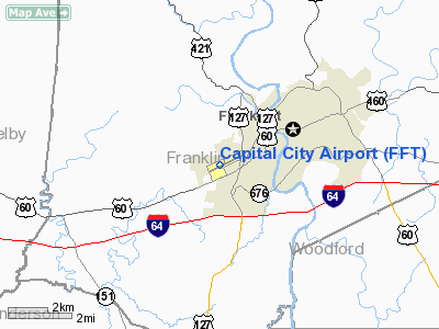
Capital City Airport (IATA: FFT, ICAO: KFFT, FAA LID: FFT) is a public use airport located one nautical mile (1.85 km) southwest of the central business district of Frankfort, a city in Franklin County, Kentucky, United States. This airport is owned by the Commonwealth of Kentucky. It is used entirely for general aviation and military aviation.
Facilities and aircraft
Capital City Airport covers an area of 375 acres (152 ha) at an elevation of 806 feet (246 m) above mean sea level. It has one asphalt paved runway designated 6/24 which measures 5,900 by 100 feet (1,798 x 30 m).
For the 12-month period ending March 8, 2007, the airport had 34,200 aircraft operations, an average of 93 per day: 88% general aviation, 9% air taxi and 3% military. At that time there were 71 aircraft based at this airport: 75% single-engine, 14% multi-engine and 11% helicopter.
The above content comes from Wikipedia and is published under free licenses – click here to read more.
|
Location &
QuickFacts
|
FAA
Information Effective: |
2008-09-25 |
|
Airport
Identifier: |
FFT |
|
Airport
Status: |
Operational |
|
Longitude/Latitude: |
084-54-22.0334W/38-10-55.1168N
-84.906120/38.181977 (Estimated) |
|
Elevation: |
812 ft / 247.50 m (Estimated) |
|
Land: |
375 acres |
|
From
nearest city: |
1 nautical miles SW of Frankfort, KY |
|
Location: |
Franklin County, KY |
|
Magnetic Variation: |
03W (1995) |
Owner & Manager
|
Ownership: |
Publicly owned |
|
Owner: |
Commonwealth Of Kentucky |
|
Address: |
90 Airport Rd
Frankfort, KY 40601 |
|
Phone
number: |
502-564-0099
ARPT DIRECTOR - SCOTT SHANNON. |
|
Manager: |
Steve Marcozzi |
|
Address: |
Capital City Airport
Frankfort, KY 40601 |
|
Phone number: |
502-564-3714 |
Airport Operations and Facilities
|
Airport
Use: |
Open to public |
|
Wind
indicator: |
Yes |
|
Segmented Circle: |
Yes |
|
Control
Tower: |
No |
|
Lighting
Schedule: |
DUSK-DAWN
ACTVT MIRL RY 06/24, PAPI RY 06 & 24, REIL RYS 06 & 24 - CTAF. |
|
Beacon
Color: |
Clear-Green (lighted land airport) |
|
Landing
fee charge: |
No |
|
Sectional chart: |
Cincinnati |
|
Region: |
ASO - Southern |
|
Traffic
Pattern Alt: |
996 ft |
|
Boundary
ARTCC: |
ZID - Indianapolis |
|
Tie-in
FSS: |
LOU - Louisville |
|
FSS on
Airport: |
No |
|
FSS Toll
Free: |
1-800-WX-BRIEF |
|
NOTAMs
Facility: |
FFT (NOTAM-d service avaliable) |
|
Federal Agreements: |
NGY |
Airport Communications
|
CTAF: |
122.800 |
|
Unicom: |
122.800 |
Airport Services
|
Fuel
available: |
100LL80 A |
|
Airframe
Repair: |
MAJOR |
|
Power
Plant Repair: |
MAJOR |
|
Bottled
Oxygen: |
NONE |
|
Bulk
Oxygen: |
NONE |
|
Runway Information
Runway 06/24
|
Dimension: |
5900 x 100 ft / 1798.3 x 30.5 m |
|
Surface: |
ASPH, Good Condition |
|
Weight Limit: |
Single wheel: 44000 lbs.
Dual wheel: 51000 lbs.
Dual tandem wheel: 82000 lbs. |
|
Edge Lights: |
Medium |
|
|
Runway 06
|
Runway 24
|
|
Longitude: |
084-54-55.2112W |
084-53-48.8556W |
|
Latitude: |
38-10-42.2869N |
38-11-07.9466N |
|
Elevation: |
812.00 ft |
785.00 ft |
|
Alignment: |
64 |
127 |
|
ILS Type: |
|
LOC/DME |
|
Traffic
Pattern: |
Left |
Left |
|
Markings: |
Non-precision instrument, Fair Condition |
Non-precision instrument, Fair Condition |
|
Crossing
Height: |
31.00 ft |
34.00 ft |
|
VASI: |
4-light PAPI on left side |
4-light PAPI on left side |
|
Visual
Glide Angle: |
3.00° |
3.50° |
|
Runway End
Identifier: |
Yes |
Yes |
|
Obstruction: |
38 ft trees, 1200.0 ft from runway, 400 ft left of
centerline, 26:1 slope to clear |
70 ft pole, 2200.0 ft from runway, 350 ft left of
centerline, 28:1 slope to clear |
|
Radio Navigation Aids
|
ID |
Type |
Name |
Ch |
Freq |
Var |
Dist |
|
FEU |
NDB |
Arnold |
|
521.00 |
03W |
4.5 nm |
|
LE |
NDB |
Blayd |
|
242.00 |
04W |
16.5 nm |
|
BRY |
NDB |
Bardstown/dcmsnd |
|
248.00 |
02W |
33.9 nm |
|
IKY |
NDB |
Springfield |
|
429.00 |
03W |
36.4 nm |
|
DVK |
NDB |
Goodall |
|
311.00 |
03W |
37.0 nm |
|
IMS |
NDB |
Madison |
|
404.00 |
03W |
43.5 nm |
|
IOB |
NDB |
Mount Sterling |
|
210.00 |
04W |
44.3 nm |
|
XYC |
NDB |
Seco |
|
393.00 |
03W |
48.7 nm |
|
TYC |
NDB |
Taylor County |
|
272.00 |
02W |
49.6 nm |
|
FFT |
VOR |
Frankfort |
|
109.40 |
03W |
0.1 nm |
|
BQM |
VOR/DME |
Bowman |
059X |
112.20 |
01W |
35.9 nm |
|
FLM |
VOR/DME |
Falmouth |
117X |
117.00 |
04W |
39.7 nm |
|
EWO |
VOR/DME |
New Hope |
045X |
110.80 |
01E |
49.3 nm |
|
HYK |
VORTAC |
Lexington |
073X |
112.60 |
00E |
24.3 nm |
|
IIU |
VORTAC |
Louisville |
095X |
114.80 |
01E |
32.1 nm |
|
ABB |
VORTAC |
Nabb |
071X |
112.40 |
01E |
42.2 nm |
|
SDF |
VOT |
Louisville Standifd |
|
111.00 |
|
39.2 nm |
Remarks
-
USE CAUTION:
UNCONTROLLED MIL HEL TFC NORTH OF RWY 06/24.
-
RWY 06 DEPS
MAINTAIN RWY HDG TIL REACHING 1000' AGL BEFORE MAKING TURN ON COURSE.
-
DANIEL BOONE HELI
LCTD 1/2 NM NORTH OF RY 24 THR.
-
PLINE 742' FM RY
24 END LGTD.
-
DEER & BIRDS ON &
INVOF ARPT.
Based Aircraft
|
Aircraft based
on field: |
71 |
|
Single Engine
Airplanes: |
53 |
|
Multi Engine
Airplanes: |
10 |
|
Helicopters: |
8 |
Operational Statistics
Time Period: 2006-03-09 - 2007-03-08
|
Aircraft
Operations: |
94/Day |
|
Air Taxi: |
9.4% |
|
General
Aviation Local: |
32.2% |
|
General
Aviation Itinerant: |
55.6% |
|
Military: |
2.9% |
Capital City Airport
Address:
Franklin County, KY
Tel:
502-564-0099,
502-564-3714
Images
and information placed above are from
http://www.airport-data.com/airport/FFT/
We
thank them for the data!
|
General Info |
| Country |
United
States |
| State |
KENTUCKY
|
| FAA ID |
FFT
|
| Latitude |
38-10-56.959N |
|
Longitude |
084-54-16.923W |
|
Elevation |
804 feet
|
| Near
City |
FRANKFORT |
We don't guarantee the information is fresh and accurate. The data may
be wrong or outdated.
For more up-to-date information please refer to other sources.
|
|


