|
|
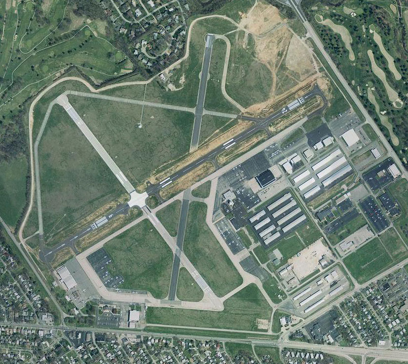
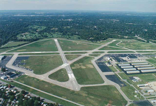
| Bowman Field |
 |
| IATA: LOU â ICAO: KLOU â FAA LID: LOU |
| Summary |
| Airport type |
Public |
| Operator |
Louisville Regional Airport Authority (LRAA) |
| Serves |
Louisville, Kentucky |
| Elevation AMSL |
546 ft / 166 m |
| Coordinates |
38°13â²41â³N 085°39â²49â³W / 38.22806°N 85.66361°W / 38.22806; -85.66361Coordinates: 38°13â²41â³N 085°39â²49â³W / 38.22806°N 85.66361°W / 38.22806; -85.66361 |
| Website |
www.flylouisville.com/bfa |
| Runways |
| Direction |
Length |
Surface |
| ft |
m |
| 6/24 |
4,326 |
1,328 |
Asphalt |
| 15/33 |
3,579 |
1,091 |
Asphalt |
| Source: Federal Aviation Administration |
For other uses, see Bowman Field (disambiguation).
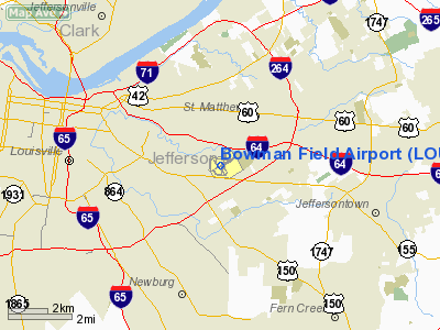
Bowman Field (IATA: LOU, ICAO: KLOU, FAA LID: LOU) is a public airport located five miles (8 km) southeast of downtown area of Louisville, in Jefferson County, Kentucky, USA. The airport covers 426 acres (1.7 km²) and has two runways. It is classified by the FAA as a reliever airport for nearby Louisville International Airport. History
Bowman Field is Kentucky's first commercial airport and one of the oldest continually operating airfields in North America. The airport has played a vital role in the growth and evolution of the country's aviation industry. It was founded by Abram H. Bowman, who was drawn to aviation by the interest generated during World War I.
Bowman found an outlet for his enthusiasm after meeting and forming a brief partnership with Louisvillian Robert H. Gast, a pilot and World War I veteran of the Royal Flying Corps. Bowman leased a parcel of land east of Louisville from the U.S. Government in 1919 to operate the airfield, which opened in 1921.
The first business ventures began with the aerial photography business in 1921, and the 465th Pursuit Squadron (Reserve) began operations at Bowman Field in 1922.
During the Great Depression, Louisvillians would often come to the Art Deco terminal building to watch airplanes depart and land as a form of inexpensive entertainment.
During the 1920s and 1930s, Eastern Air Lines, Trans World Airlines (TWA) and the original Continental Airlines operated passenger and mail service in and out of Bowman Field. Commercial airline service continued until 1947, when operations were transferred to Standiford Field.
During World War II, Bowman Field was one of the nation's most important training bases as well as the nation's busiest airport. The facility became known as "Air Base City" when a bomber squadron moved in and more than 1,600 recruits underwent basic training in a three-month period. The United States Army Air Forces' school for flight surgeons, medical technicians, and flight nurses also called Bowman Field home.
Bowman Field was used in the James Bond film Goldfinger as the base for Pussy Galore's Flying Circus; principal photography of hangars, aircraft, etc., were done there in fall of 1963.[1]
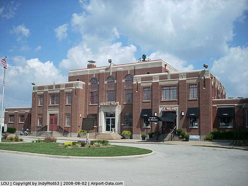
Historic buildings
In 1988, three adjacent buildings at the airport were added to the National Register of Historic Places as the Bowman Field Historic District. They are the airport Administration Building (1929; 1936-37), the Curtiss Flying Service Hangar (1929), and the Army Air Corps Hangar (1931-32). Since many urban airports are located in industrial areas, this verdant setting is unusual and contributes to the ambience of the Bowman Field Historic District.
The buildings of the Bowman Field Historic District are related not only by historical function and physical proximity, but by their Art Deco/Art Moderne styling and through the use of masonry materials such as brick, stone and concrete.
The dominant landmark of Bowman Field is its terminal, more commonly known as the Administration Building, appropriately styled in aerodynamic Moderne. As constructed in 1929, it was a fairly modest two-story structure with one-story wings, housing administrative and communications offices, weather station, and restaurant. During 1936 and 1937 it was nearly tripled in size. This was accomplished by demolishing the east wing and retaining the west and central sections to serve as west wings of the new building. The Administration Building faces an elliptical landscaped island surrounded by a driveway and paved parking area.
Charles Lindbergh landed the Spirit of St. Louis here in 1927 on a visit to 10,000 spectators.
The 1920s Art-Deco style Le Relais French restaurant has made its home in the airportâs historic terminal for more than 25 years.
Safety
Bowman Field is surrounded by tree-lined suburban neighborhoods, but accidents are relatively rare. As of 2008, the most recent two landing accidents had occurred in April 2008 and April 2002.
Current operations
 | |
Bowman Field |
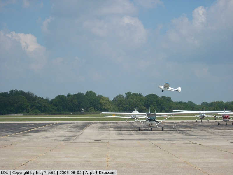
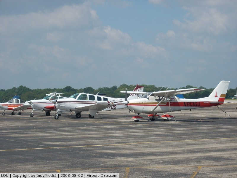
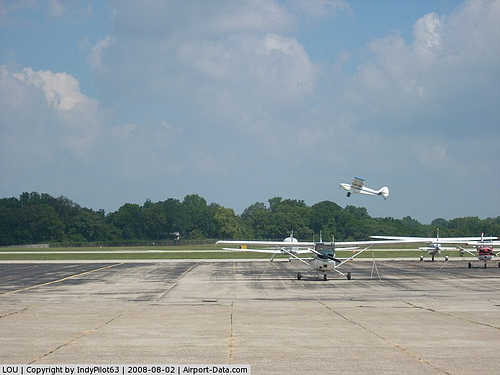
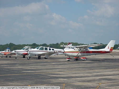
Today, Bowman Field is home to hundreds of privately owned aircraft as well as several commercial operations, including Central American Airways, which opened its doors in 1946, Falcon Aviation (which can trace its roots to the old Louisville Flying Service that began operations in 1932), Kentucky Flying Service, and Louisville Executive Aviation. The Aero Club of Louisville, Inc. and the Glendale Flying Club also operate out of the airport. Several flight schools operate there as well.
For the 12-month period ending June 30, 2007, the airport had 98,722 aircraft operations, an average of 270 per day: 97% general aviation, 2% air taxi and <1% military. There are 368 aircraft based at this airport: 82% single-engine, 14% multi-engine, 2% jet, and 2% helicopter.
Kentucky Flying Service is no longer in operation. It was started by Captain Richard C. Mulloy who flew C-46s and C-47s with the Flying Tigers over "The Hump" in World War II. He was known by employees and students of Kentucky Flying Service as "Dick Mulloy," and died surrounded by his family in Louisville on Saturday, May 8, 2010, at the age of 89.
Bowman Field is currently operated by the Louisville Regional Airport Authority, which also operates Louisville International Airport.
The above content comes from Wikipedia and is published under free licenses – click here to read more.
|
 |
(Click on the photo to enlarge) |
|
 |
(Click on the photo to enlarge) |
|
 |
(Click on the photo to enlarge) |
|
 |
(Click on the photo to enlarge) |
|
Location &
QuickFacts
|
FAA
Information Effective: |
2008-09-25 |
|
Airport
Identifier: |
LOU |
|
Airport
Status: |
Operational |
|
Longitude/Latitude: |
085-39-49.4000W/38-13-40.8000N
-85.663722/38.228000 (Estimated) |
|
Elevation: |
546 ft / 166.42 m (Surveyed) |
|
Land: |
426 acres |
|
From
nearest city: |
5 nautical miles SE of Louisville, KY |
|
Location: |
Jefferson County, KY |
|
Magnetic Variation: |
01W (1980) |
Owner & Manager
|
Ownership: |
Publicly owned |
|
Owner: |
Reg Apt Auth Lou & Jeff Co |
|
Address: |
P O Box 9129
Louisville, KY 40209-0129 |
|
Phone number: |
502-368-6524 |
|
Manager: |
Bill Musslewhite |
|
Address: |
2815 Taylorsville Road
Louisville, KY 40205-3166 |
|
Phone number: |
502-314-3196 |
Airport
Operations and Facilities
|
Airport
Use: |
Open to public |
|
Wind
indicator: |
Yes |
|
Segmented Circle: |
No |
|
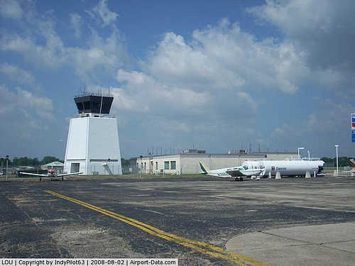
Control
Tower: |
Yes |
|
Lighting
Schedule: |
DUSK-DAWN
ACTVT MIRL RYS 06/24 & 14/32 - CTAF. |
|
Beacon
Color: |
Clear-Green (lighted land airport) |
|
Landing
fee charge: |
No |
|
Sectional chart: |
St Louis |
|
Region: |
ASO - Southern |
|
Boundary
ARTCC: |
ZID - Indianapolis |
|
Tie-in
FSS: |
LOU - Louisville
CTC LOUISVILLE RADIO FOR AIRPORT ADVISORY SERVICE ON 119.5 WHEN TOWER
IS CLSD. |
|
FSS on
Airport: |
No |
|
FSS Toll
Free: |
1-800-WX-BRIEF |
|
NOTAMs
Facility: |
LOU (NOTAM-d service avaliable) |
|
Federal Agreements: |
NGPY3 |
Airport Communications
|
CTAF: |
119.500 |
|
Unicom: |
122.950 |
Airport Services
|
Fuel
available: |
100LLA |
|
Airframe
Repair: |
MAJOR |
|
Power
Plant Repair: |
MAJOR |
|
Bottled
Oxygen: |
HIGH/LOW |
|
Bulk
Oxygen: |
HIGH/LOW |
|
Runway Information
Runway 06/24
|
Dimension: |
4357 x 75 ft / 1328.0 x 22.9 m |
|
Surface: |
ASPH, Fair Condition |
|
Weight Limit: |
Single wheel: 30000 lbs. |
|
Edge Lights: |
Medium |
|
|
Runway 06
|
Runway 24
|
|
Longitude: |
085-40-10.0100W |
085-39-22.9100W |
|
Latitude: |
38-13-31.5400N |
38-13-53.3300N |
|
Elevation: |
544.00 ft |
531.00 ft |
|
Alignment: |
60 |
127 |
|
Traffic
Pattern: |
Left |
Left |
|
Markings: |
Non-precision instrument, Good Condition |
Non-precision instrument, Good Condition |
|
Crossing
Height: |
48.00 ft |
42.00 ft |
|
Displaced
threshold: |
847.00 ft |
310.00 ft |
|
VASI: |
2-light PAPI on left side |
2-light PAPI on left side |
|
Visual
Glide Angle: |
4.00° |
3.80° |
|
Runway End
Identifier: |
|
Yes |
|
Obstruction: |
53 ft trees, 269.0 ft from runway, 70 ft left of
centerline
APCH RATIO 20:1 TO DSPLCD THLD OVER 65 FT TREE; DISTANCE 1140 FT - 235
FT LEFT.
+8 FT 6 INCH FENCE 956 FT FROM DSPLCD THLD; ROAD 992 FT FM DSPLCD THLD. |
27 ft trees, 410.0 ft from runway, 7:1 slope to clear
APCH RATIO 20:1 TO DSPLCD THLD. |
|
Decleard
distances: |
Take off run available 4047.00 ft
Take off distance available 4357.00 ft
Actual stop distance available 4316.00 ft
Landing distance available 3469.00 ft |
Take off run available 3509.00 ft
Take off distance available 4357.00 ft
Actual stop distance available 4165.00 ft
Landing distance available 3856.00 ft |
|
Runway 14/32
|
Dimension: |
3579 x 75 ft / 1090.9 x 22.9 m |
|
Surface: |
ASPH, Good Condition |
|
Weight Limit: |
Single wheel: 30000 lbs. |
|
Edge Lights: |
Medium |
|
|
Runway 14
|
Runway 32
|
|
Longitude: |
085-40-06.4957W |
085-39-39.8741W |
|
Latitude: |
38-13-52.9248N |
38-13-24.4488N |
|
Elevation: |
538.00 ft |
518.00 ft |
|
Alignment: |
127 |
127 |
|
Traffic
Pattern: |
Left |
Left |
|
Markings: |
Non-precision instrument, Good Condition |
Non-precision instrument, Good Condition |
|
Crossing
Height: |
31.00 ft |
42.00 ft |
|
Displaced
threshold: |
206.00 ft |
341.00 ft |
|
VASI: |
4-box on left side |
4-box on left side |
|
Visual
Glide Angle: |
3.00° |
3.00° |
|
Runway End
Identifier: |
|
Yes |
|
Obstruction: |
18 ft trees, 210.0 ft from runway, 200 ft left of
centerline
APCH RATIO 20:1 TO DSPLCD THLD.
+9 FT FENCE 394 FT FROM DSPLCD THLD. |
75 ft trees, 825.0 ft from runway, 200 ft left of
centerline, 8:1 slope to clear
APCH RATIO 18:1 TO DSPLCD THR.
ROAD 600 FT FM DSPLCD THLD. |
|
Decleard
distances: |
Take off run available 3238.00 ft
Take off distance available 3579.00 ft
Actual stop distance available 3579.00 ft
Landing distance available 3373.00 ft |
Take off run available 3373.00 ft
Take off distance available 3579.00 ft
Actual stop distance available 3466.00 ft
Landing distance available 3125.00 ft |
|
Radio Navigation Aids
|
ID |
Type |
Name |
Ch |
Freq |
Var |
Dist |
|
GOI |
NDB |
Godman |
|
396.00 |
02W |
21.9 nm |
|
BRY |
NDB |
Bardstown/dcmsnd |
|
248.00 |
02W |
24.4 nm |
|
IMS |
NDB |
Madison |
|
404.00 |
03W |
33.4 nm |
|
FEU |
NDB |
Arnold |
|
521.00 |
03W |
39.9 nm |
|
IKY |
NDB |
Springfield |
|
429.00 |
03W |
41.0 nm |
|
EQZ |
NDB |
Captain |
|
308.00 |
02W |
41.1 nm |
|
RRJ |
NDB |
Oranj |
|
368.00 |
02W |
44.5 nm |
|
OVO |
NDB |
North Vernon |
|
374.00 |
02W |
49.5 nm |
|
LE |
NDB |
Blayd |
|
242.00 |
04W |
49.6 nm |
|
MYS |
VOR |
Mystic |
|
108.20 |
01W |
34.0 nm |
|
FFT |
VOR |
Frankfort |
|
109.40 |
03W |
35.8 nm |
|
BQM |
VOR/DME |
Bowman |
059X |
112.20 |
01W |
0.1 nm |
|
FTK |
VOR/DME |
Fort Knox |
033X |
109.60 |
01W |
24.2 nm |
|
EWO |
VOR/DME |
New Hope |
045X |
110.80 |
01E |
35.8 nm |
|
IIU |
VORTAC |
Louisville |
095X |
114.80 |
01E |
8.5 nm |
|
ABB |
VORTAC |
Nabb |
071X |
112.40 |
01E |
21.7 nm |
|
SDF |
VOT |
Louisville Standifd |
|
111.00 |
|
4.6 nm |
Remarks
-
STAGE 3
COMPLIANCE RQRD FOR TURBOJET ACFT; PPR FOR ALL ACFT OVER 30000 LBS GWT.
CALL AMGR 502-368-6524
FOR PPR.
-
WHEN ATCT CLSD
TRNG OPNS PROHIBITED.
-
NMRS OBSTNS,
PRIMARLIY TREES IN ALL RY APCH SFCS.
-
FLT NOTIFICATION
SERVICE(ADCUS) AVBL.
-
BE ALERT FOR
BIRDS ON & INVOF ARPT DURG DALGT HRS.
-
RY 06, +24' BLDG,
262' RT OF RY END, VIOLATES 7:1 TRANSITIONAL SFC.
-
EXISTED PRIOR TO 1959.
Based Aircraft
|
Aircraft based
on field: |
221 |
|
Single Engine
Airplanes: |
178 |
|
Multi Engine
Airplanes: |
42 |
|
Helicopters: |
1 |
Operational Statistics
Time Period: 2006-07-01 - 2007-06-30
|
Aircraft
Operations: |
271/Day |
|
Air Taxi: |
2.2% |
|
General
Aviation Local: |
51.2% |
|
General
Aviation Itinerant: |
46.3% |
|
Military: |
0.3% |
Elwood Airport
Address:
Jefferson County, KY
Tel:
502-368-6524, 502-314-3196
Images
and information placed above are from
http://www.airport-data.com/airport/LOU/
We
thank them for the data!
|
General Info |
| Country |
United
States |
| State |
KENTUCKY
|
| FAA ID |
LOU
|
| Latitude |
38-13-40.800N |
|
Longitude |
085-39-49.400W |
|
Elevation |
546 feet
|
| Near
City |
LOUISVILLE |
We don't guarantee the information is fresh and accurate. The data may
be wrong or outdated.
For more up-to-date information please refer to other sources.
|
|