 |
|
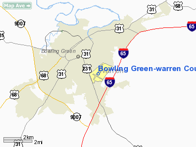
Bowling Green-warren County Regional Airport |
| Bowling Green-Warren County Regional Airport |
| IATA: BWG â ICAO: KBWG â FAA LID: BWG |
| Summary |
| Airport type |
Public |
| Owner |
City of Bowling Green & Warren County |
| Location |
Bowling Green, Kentucky |
| Elevation AMSL |
547 ft / 167 m |
| Coordinates |
36°57â²52â³N 086°25â²11â³W / 36.96444°N 86.41972°W / 36.96444; -86.41972 |
| Website |
www.bgwcairport.org |
| Runways |
| Direction |
Length |
Surface |
| ft |
m |
| 3/21 |
6,500 |
1,981 |
Asphalt |
| 12/30 |
3,955 |
1,205 |
Asphalt |
| Statistics (2005) |
| Aircraft operations |
62,640 |
| Based aircraft |
74 |
| Source: Federal Aviation Administration |
Bowling Green-Warren County Regional Airport (IATA: BWG, ICAO: KBWG, FAA LID: BWG) is a public airport located two miles (3 km) southeast of the central business district of Bowling Green, a city in Warren County, Kentucky, United States. This airport is publicly owned by the City of Bowling Green and Warren County. The site was established in 1934 as a military airfield. It is not currently served by scheduled airline service, though service was once available on US Airways Express dba Air Kentucky.
Facilities and aircraft
Bowling Green-Warren County Regional Airport covers an area of 525 acres (212 ha) which contains two runways:
- Runway 3/21: 6,500 x 150 ft (1,981 x 46 m), Surface: Asphalt
- Runway 12/30: 3,955 x 150 ft (1,205 x 46 m), Surface: Asphalt
For 12-month period ending November 30, 2005, the airport had 62,640 aircraft operations, an average of 171 per day: 96% general aviation, 3% military, 1% air taxi and <1% scheduled commercial. There are 74 aircraft based at this airport: 85% single engine, 9% multi-engine (7) and 5% jet aircraft.
- Fixed Base Operator: Co-Mar Aviation - Operations include aircraft maintenance, fuel services, and aircraft hangers/tie downs.
The above content comes from Wikipedia and is published under free licenses – click here to read more.
|
Location &
QuickFacts
|
FAA
Information Effective: |
2008-09-25 |
|
Airport
Identifier: |
BWG |
|
Airport
Status: |
Operational |
|
Longitude/Latitude: |
086-25-10.8000W/36-57-52.3000N
-86.419667/36.964528 (Estimated) |
|
Elevation: |
547 ft / 166.73 m (Surveyed) |
|
Land: |
560 acres |
|
From
nearest city: |
2 nautical miles SE of Bowling Green, KY |
|
Location: |
Warren County, KY |
|
Magnetic Variation: |
02W (1995) |
Owner & Manager
|
Ownership: |
Publicly owned |
|
Owner: |
City Bowling Green-warren Co |
|
Address: |
1000 Woodhurst St
Bowling Green, KY 42103 |
|
Phone
number: |
270-842-1101 |
|
Manager: |
Rob Barnett |
|
Address: |
1000 Woodhurst St
Bowling Green, KY 42103 |
|
Phone number: |
270-842-1101 |
Airport Operations and Facilities
|
Airport
Use: |
Open to public |
|
Wind
indicator: |
Yes |
|
Segmented Circle: |
Yes
NSTD LIGHTED WINDSOCK. |
|
Control
Tower: |
No |
|
Lighting
Schedule: |
DUSK-DAWN
ACTVT HIRL RY 03/21 AND REIL RYS 03 & 21 - CTAF. |
|
Beacon
Color: |
Clear-Green (lighted land airport) |
|
Landing
fee charge: |
No |
|
Sectional chart: |
St Louis |
|
Region: |
ASO - Southern |
|
Boundary
ARTCC: |
ZME - Memphis |
|
Tie-in
FSS: |
LOU - Louisville |
|
FSS Toll
Free: |
1-800-WX-BRIEF |
|
NOTAMs
Facility: |
BWG (NOTAM-d service avaliable) |
|
Certification type/date: |
IV A U 05/197
24 HR PPR FOR ACR OPNS WITH MORE THAN 30 PSGR SEATS CALL AMGR
270-842-1101. |
|
Federal Agreements: |
NGY3 |
Airport Communications
|
CTAF: |
123.000 |
|
Unicom: |
123.000 |
Airport Services
|
Fuel
available: |
100LLA |
|
Airframe
Repair: |
MAJOR |
|
Power
Plant Repair: |
MAJOR |
|
Bottled
Oxygen: |
NONE |
|
Runway Information
Runway 03/21
|
Dimension: |
6500 x 150 ft / 1981.2 x 45.7 m |
|
Surface: |
ASPH, Good Condition |
|
Weight Limit: |
Single wheel: 25000 lbs.
Dual wheel: 38000 lbs.
Dual tandem wheel: 60000 lbs. |
|
Edge Lights: |
High |
|
|
Runway 03
|
Runway 21
|
|
Longitude: |
086-25-30.1207W |
086-24-50.2236W |
|
Latitude: |
36-57-31.2619N |
36-58-26.9818N |
|
Elevation: |
547.00 ft |
520.00 ft |
|
Alignment: |
30 |
127 |
|
ILS Type: |
ILS |
|
|
Traffic
Pattern: |
Left |
Left |
|
Markings: |
Precision instrument, Fair Condition |
Precision instrument, Fair Condition |
|
VASI: |
4-light PAPI on left side |
4-light PAPI on left side |
|
Visual
Glide Angle: |
3.00° |
3.00° |
|
Runway End
Identifier: |
Yes |
Yes |
|
Runway 12/30
|
Dimension: |
3955 x 150 ft / 1205.5 x 45.7 m |
|
Surface: |
ASPH, Fair Condition |
|
Weight Limit: |
Single wheel: 25000 lbs.
Dual wheel: 38000 lbs.
Dual tandem wheel: 60000 lbs. |
|
Edge Lights: |
Medium |
|
|
Runway 12
|
Runway 30
|
|
Longitude: |
086-25-33.0713W |
086-24-50.8211W |
|
Latitude: |
36-57-50.6963N |
36-57-31.2072N |
|
Elevation: |
531.00 ft |
531.00 ft |
|
Alignment: |
120 |
127 |
|
Traffic
Pattern: |
Left |
Left |
|
Markings: |
Basic, Good Condition |
Basic, Good Condition |
|
Displaced
threshold: |
0.00 ft |
349.00 ft |
|
Obstruction: |
3 ft post, 201.0 ft from runway, 50 ft left of centerline
+1 FT FENCE 190 FT FM RY END 95 FT LEFT; 20:1 AT DISPLACEMENT. |
15 ft road, 270.0 ft from runway, 4:1 slope to clear
+54' TREE DIST 860' 200'L; 15:1 BASED ON DSPLCD THR.
+10' FENCE 190' FROM RWY END 250' R TO 250' L. |
|
Radio Navigation Aids
|
ID |
Type |
Name |
Ch |
Freq |
Var |
Dist |
|
BVQ |
NDB |
Beaver Creek |
|
260.00 |
02W |
20.0 nm |
|
LFB |
NDB |
Lafayette |
|
245.00 |
02W |
32.1 nm |
|
PED |
NDB |
Needmore |
|
221.00 |
01W |
35.2 nm |
|
GMH |
NDB |
Muhlenberg |
|
362.00 |
01E |
38.8 nm |
|
ON |
NDB |
Music |
|
279.00 |
03W |
41.5 nm |
|
HIX |
NDB |
Honey Grove |
|
356.00 |
01W |
44.4 nm |
|
JUE |
NDB |
Lebanon |
|
414.00 |
02W |
46.7 nm |
|
VI |
NDB |
Opery |
|
344.00 |
02W |
47.1 nm |
|
FK |
NDB |
Airbe |
|
273.00 |
01W |
49.7 nm |
|
BWG |
VORTAC |
Bowling Green |
126X |
117.90 |
02E |
2.4 nm |
|
CCT |
VORTAC |
Central City |
035X |
109.80 |
01W |
47.6 nm |
Remarks
-
BE ALERT FOR
LARGE NUMBERS OF BIRDS ON & INVOF ARPT.
-
IFR CLEARANCES TO
BE CANCELED ON 122.4 LOUISVILLE FSS
-
EXISTED PRIOR TO 1959.
Based Aircraft
|
Aircraft based
on field: |
58 |
|
Single Engine
Airplanes: |
49 |
|
Multi Engine
Airplanes: |
5 |
|
Jet Engine
Airplanes: |
3 |
|
Helicopters: |
1 |
Operational Statistics
Time Period: 2006-12-01 - 2007-11-30
|
Aircraft
Operations: |
172/Day |
|
Commerical: |
0.2% |
|
Air Taxi: |
1.3% |
|
General
Aviation Local: |
51.9% |
|
General
Aviation Itinerant: |
44.1% |
|
Military: |
2.5% |
Bowling Green-warren County Regional
Airport
Address:
Warren County, KY
Tel:
270-842-1101
Images
and information placed above are from
http://www.airport-data.com/airport/BWG/
We
thank them for the data!
|
General Info |
| Country |
United
States |
| State |
KENTUCKY
|
| FAA ID |
BWG
|
| Latitude |
36-57-52.300N |
|
Longitude |
086-25-10.800W |
|
Elevation |
547 feet
|
| Near
City |
BOWLING
GREEN |
We don't guarantee the information is fresh and accurate. The data may
be wrong or outdated.
For more up-to-date information please refer to other sources.
|
|


